Flytomap All in One HD Charts
| Category | Price | Seller | Device |
|---|---|---|---|
| Navigation | $14.99 | Flytomap | iPhone, iPad, iPod |


► The charts downloaded are resident in the app. No internet connection required!
Flytomap All In One HD works on all Apple devices
FlyToMap™ offers a revolutionary app; you can download any chart worldwide (500+) free of charge
Check out your area on viewer.flytomap.com
- All USA Marine charts (US All, East, West, Great Lakes, Major Rivers, Florida, Texas, California, etc.)
- USA Lake Maps 15000+ : Minnesota, Maine, Michigan, Massachusetts, Wisconsin, Texas, California, Florida, Iowa, North and South Dakota...and many more.
- 150+ USA Parks and Forests
- Australia Marine Charts
- Australia Parks
- New Zealand Marine charts
- All Europe Marine Charts
- 200+ major EU Parks
- The world's most famous holiday destinations ie: Caribbean, Seychelles, Mauritius, Maldives, Canary Islands, Azores, Bora Bora, Bali, Oslo Fjord .. and many more.
- Canada Lake Maps: Alberta, Lake of the Wood.. and many more.
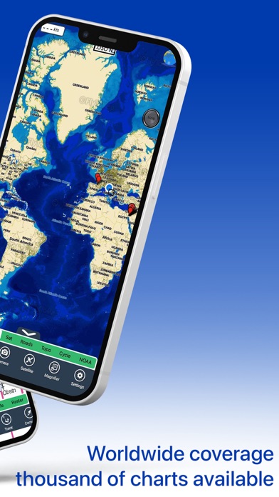
► Worldwide Marine and Outdoor Maps available, thanks to viewer.flytomap.com
► Worldwide Satellite images overlay on charts
► Worldwide Terrain features overlay on charts, thanks to Open Street Map, Open Cycle Map, Bing, Earth, GMap
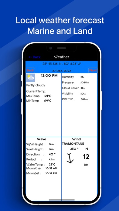
► Interactive Weather forecast
► NOAA raster charts seamless with continuous updates from the official Government server
► ActiveCaptain - Worldwide boaters community, with 200.000 + Captains
Use to Explore:
√ Latitudes and Longitudes to go to your favorite places
√ Search your Favorite points directly
√ Zoom, Rotate and Pan fast just by a finger touch
√ Quick Object information just tapping, thanks to vector technology
√ GPS Heading Vector Towards the direction movement
√ Distance Measurement Tool to easily calculate the distance from one location to another
√ Route planning, unlimited Waypoints - Insert the target/destination and see in real time your speed, distance and bearing
√ Magnified Lens for all info
√ Unlimited Tracks, Markers, Geo-tagged photos, records and share via email, visible on Google, Flytomap Viewer, KMZ format - Store your track without the need of cellular data or mobile signal
√ Select Depth Contours
√ a la carte menu
√ iOS background mode - Flytomap works in background as well, you can swap with another app and receive/make calls send sms while track recording.
√ Optimized battery usage
√ And so much more to come - It’s the only app you will ever need! Our charts are installed on: NAVICO LOWRANCE B&G NORTHSTAR EAGLE SIMRAD
Follow us:
▶ Twitter @flytomap
▶ Web Site flytomap.com
▶ Facebook facebook.com/flytomap
FlytoMap™ has a wide range of Applications and Maps for you to use - Free of charge on Flytomap All In One !
- WATER MAPS
Electronic Nautical Charts with the same accuracy and detail as on your chart plotter. Maps include Coastline, Anchoring areas, Fishing areas, Restriction areas, Obstructions, Rocks, Buoys, Beacons, Lights, Depth contours, Spot Soundings and more.
- LAKE MAPS
High quality lake maps with detailed information: Depth Contours, Boat Ramps, Fishing spots etc. Maps also include Trails, Roads and Railways information.
- PARK MAPS:
Extremely advanced electronic charts with information collected from National/State Park and Forest Services and many other local sources. The maps contain trails (Hiking, Biking, Equestrian trails etc.,) and Points of interest (POI) like Campgrounds, Visitor Centers, Lookout points, Eating places, Ranger Stations, Picnic areas, Boat/Canoe ramps, Parking areas etc..
- TRAVEL MAPS
These Maps cover the most interesting touristic areas combining Sea and Land information to allow you a complete travel experience.
Reviews
Handy with Great Stuff
Cameoron
Great app! Nice features! I really like this app and I love having it on my ipad. So convenient and it works really well. Awesome!!!
Nice app
Chris_dun
I recently downloaded it for my iPad and have been blown away by it’s user interface & variety of maps. It offers everything you could need in a personal GPS and I use it everytime when I go out. All maps are awesome! I highly recommend it for anyone.
Good gps application
Bart55K
App is Flawless! I have checked few water maps for boating from northern Florida to border of Texas the details were way accurate and I think very useful for boating and cruise. This app is much better than a gps unit. It gives all the information needed for a boater for safe journey. It's easy to use and helps me track my routes. I have heard of flytomap apps before and now I have the best one on my ipad.
Best app!
John Mke
Very accurate, easy to use app! It has amazing features with intuitive interface. Having it on my device is a great deal and joy using it. I have used it in many times so far and it works great.
Like this!
STV_broad
This app keeps getting better and better! If you want to track your outdoor activities, locate exact location on map then this is the best app out there for ipad! It has many interesting map features I never seen in any app before. It tracks every move and speed. It’s just an amazing. Like it!
Lot of Info
Kiaflor
Awesome application I found on Appstore. Very impressed with variety of maps and bulk of functions. Never seen an app published for such a low price. If this is an offer then ok orelse it's a must buy application for any one interested in any outdoor activity. I definitely suggest...
Producr is a sham
Grandisleguy
Anytime one tries to download a map the product exits and puts you back at thr home screen. I've been badly ripped off and I want my money back and these people decertified as app providers
Good Tech.
Davevo
App interface is intuitive I always feel confident when I'm out with app. able to see my route towards target on map accurately, offline maps are quite useful right in front of me while driving or hiking. App's very helpful.
Incredible Map
Acylit
I can track my distance and direction towards my destination, tracks my routes, records them automatically and allows to email them as kmz and very easy to share with friends. The depths and other features on map overlay are excellent, very detailed with accurate attribution. In my point of view this app is incredibly rich.