Marine Navigation - Lake Depth Maps - USA - Offline Gps Nautical Charts for Fishing, Sailing and Boating
| Category | Price | Seller | Device |
|---|---|---|---|
| Navigation | $19.99 | Bist LLC | iPhone, iPad, iPod |

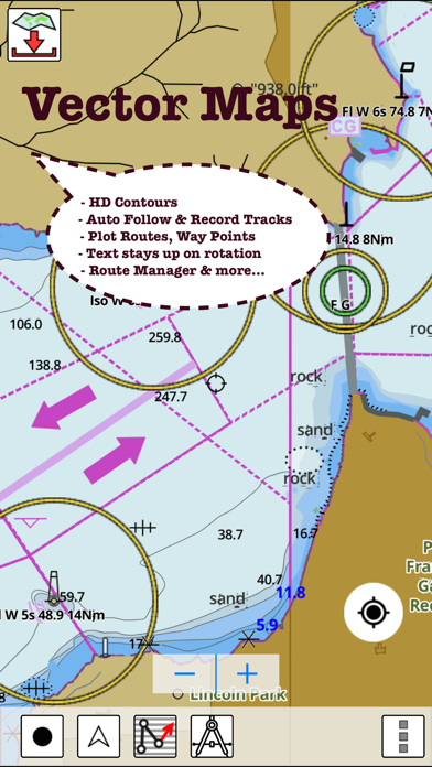
* Hardware/GPU accelarated vector charts (text stays upright on rotation).
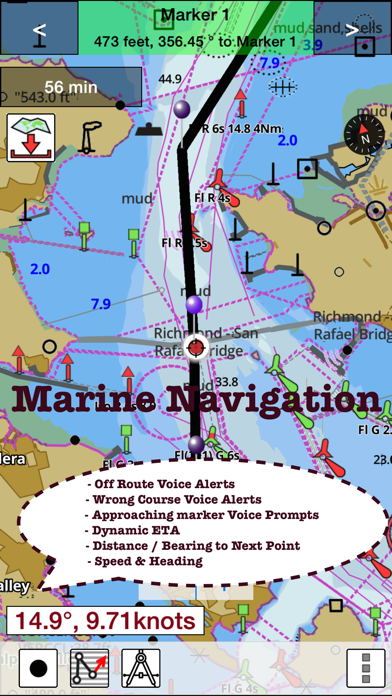
* Voice Prompts for marine navigation (requires GPS )
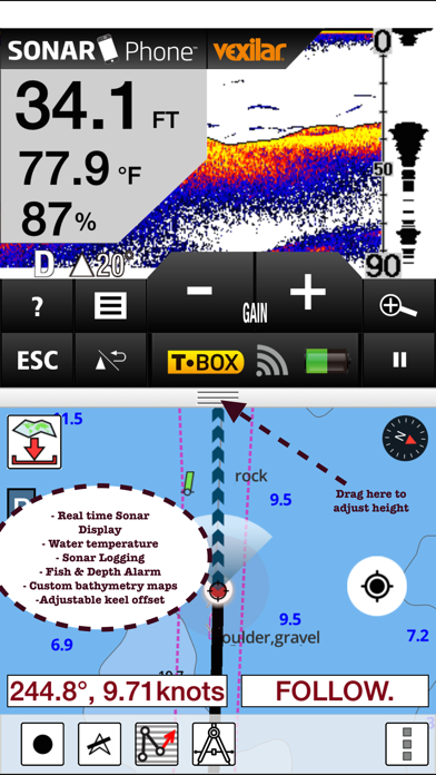
* 1ft / 3ft depth contour maps for anglers for selected lake maps.
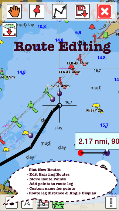
* Supports GPX/KML for boating route editing/import.
* Tide & Currents prediction.
* Seamless chart quilting of marine charts
* Enter way points
* Record tracks, Autofollow with realtime track overlay
* Voice Prompts for marine navigation (requires GPS )
-prompts when approaching a boating route marker
-Continous distance and ETA updates
-Alerts when sailing/boating off route
-Alerts when boating in wrong direction
*Route Editing/Creation
-Create routes from scratch
-Edit existing GPX/KML routes.
-Add custom description to any route point.
-Drop markers along route.
* Offline NOAA marine, lake & river charts
-Visually download using grid
-Textual search
* Tide & Currents
- High / Low tides.
- Tidal Currents.
- Active currents stations.
*Seamless chart quilting of marine charts
*Distance Bearing tool
*Create custom way points
- Using GPS
-Select point on map
-Manually enter latitude & longitude coordinates
*Pan/Zoom/My Location
* Record Marine GPS tracks
* View tracks overlay
* Live track animation
* Track analytics/stats
* Export GPX trcks.
-Export to SDCard
-Share GPX tracks with friends.
* Auto Follow Mode (Course up)
-Continuously updates boat's location on chart
- Adjustable update frequency
Sample Nautical Charts (please visit http://gpsnauticalcharts.com/main/folio-catalog-nautical-charts-app for complete list)
SUGARLOAF KEY-KEY WEST
PORT RICHEY TAMPA BAY - CLEARWATER HBR
EAST BAY-WEST BAY FLORIDA
ST JOSEPH, ST ANDREW BAYS
INTRACOASTAL WATERWAY MATECUMBE-GRASSY KEY
CHESAPEAKE BAY CAPE CHARLES-NORFOLK HARBOR
ANCLOTE KEYS-CRYSTAL RIVER
ST JOSEPH SOUND
MIAMI HARBOR
Minnesota lakes - Kabetogama, Minnetonka, Waconia,Leech,Mille Lacs
Lake Keowee,Jocassee,Hartwell,Greenwood,Lake Murray
Mark Twain,Ozarks,Table Rock
Lake St. Clair
Lake Kentucky
KEY WEST-THE MISSISSIPPI RIVER
SAN PEDRO CHANNEL
LAKE MICHIGAN STONY LAKE-POINT BETSIE
APALACHICOLA BAY-CAPE SAN BLAS
EAST CAPE-MORMON KEY
CAPE HENLOPEN-INDIAN RIVER INLET
CHESAPEAKE BAY CAPE HENRY-THIMBLE SHOAL LIGHT
DULUTH-SUPERIOR HARBOR
MONHEGAN ISLAND-CAPE ELIZABETH
LAKE ONTARIO - CLAYTON-FALSE DUCKS ISL
Lake Winnipesaukee
SAN FRANCISCO ENTRANCE
MIAMI-MARATHON, FLORIDA BAY
CAPE MAY-FENWICK ISLAND
MISSISSIPPI RIVER-GALVESTON
CAPE CANAVERAL-KEY WEST
DELAWARE RIVER WILMINGTON-PHILADELPHIA
FLORIDA KEYS SOMBRERO KEY-SAND KEY
SAN PABLO BAY
RAINY LAKE BIG ISLAND MINN-OAKPOINT ISL ONT
INTRACOASTAL WATERWAY - BISCAYNE BAY
EVERGLADES NTL PARK - SHARK RVR-LOSTMANS RVR
MIAMI-MARATHON & FLORIDA BAY
BLACKBURN BAY
LAKE HURON
LAKE TAHOE
STRAITS OF MACKINAC
NORFOLK HARBOR & ELIZABETH RIVER
SAN DIEGO-SANTA ROSA ISLAND
DELAWARE BAY
CHOPTANK RIVER CAMBRIDGE-GREENSBORO
FORT LAUDERDALE PORT EVERGLADES
ST SIMONS SOUND-TOLOMATO RIVER
CHESAPEAKE DELAWARE CANAL
CAPE MENDOCINO
STRAIT OF JUAN DE FUCA ENTRANCE
PORT RICHEY CLEARWATER HBR
PAMPANO BEACH-HALLADALE FLORIDA
LAKE ERIE
LAKE MICHIGAN INCLUDING GREEN BAY
MAIMI-MARATHON and FLORIDA BAY
SANTA CATALINA ISLAND
APALACHICOLA BAY-LAKE WIMICO
Battery Disclaimer:
"Continued use of GPS running in the background can dramatically decrease battery life."
Reviews
Route Manager
sunil137
I was able to transfer all my existing routes from my PC route planning software to this. I am glad it did not loose the names of points i had so meticulously entered. Looking forward to using it this summer.
Precise route plotting
Satyajit
I like how easy it is to plot precise routes using this app. Finally an app that gets it right.
Great app
Sgrover01
Perfect app with perfect precision.. Now I don't have to use those clunky devices this summer. Love it..
STAY AWAY!!!
Kabkabkab76
Astoundingly bad - fraudulent would be a better description. This is a beta version, and a very early one at that. The screenshots show a simulator - the actual app does not have the functionality shown or advertised. The instructions do not even exist - site says "coming soon". The existing reviews are bogus, clearly posted by the developer (look at the names). I can't believe this made it into the App Store.
US Nautical Charts-NOAA-Marine Charts app for sailing boating kayaking and fishing - USA
mikallen
I hold a 50 ton inland Masters license and am a professional mariner in the San Francisco Bay Area. I have used many professional GPS based electronic navigation applications both on dedicated hardware devices and PC based applications such as Navtrek from Nobeltec Software. I recently downloaded GPS Nautical Charts on my iPhone while on vacation in Maui, Hawaii. I was very impressed with how easy it was for me to download the charts for the regions I wanted as well as the ease of use for all the functions, i.e. location indication based on the iPhone's GPS, route planning, track, way points etc. I liked this program so much that tomorrow I'm buying an iPad with 3G/LTE connectivity that has the built in GPS sensor. I plan to install this software on my new iPad and use it on the bay where I crew on the local charter sailboat NEHEMIAH. Also the customer support has been outstanding. All my questions asked via email were answered immediately and provided complete solutions to any issues I had. Anyone who has experience with any of the existing dedicated hardware or PC based electronic navigation software will be very impressed with US Nautical Charts-NOAA-Marine Carts app for sailing boating kayaking and fishing - USA! I just purchased the iPad and installed US Nautical Charts-NOAA-Marine Charts app for sailing boating kayaking and fishing - USA on the iPad as well and am very happy with the details of the chart images, the functions and the user support. While this app. for the iPad is identical to the iPhone app., the larger platform makes it quite a bit easier to operate. One additional note: I've read some of the negative reviews of this app and am quite baffled by the negativity. While I can't compare it to other iPad or iPhone apps., I think this app performs quite well especially when I remember that just a few years ago I needed a PC, Garmin or other brand GPS along with the software like Nobeltek to do the same tasks. Also, connecting the GPS to the PC required a special interface. Unless one is a power user who needs distance off, radar & weather overlays etc. this is a great app.
Texas lakes
Edwardb1970
I tried almost every lake app out there. This is the only one I found that offered comprehensive coverage for inland Texas lake maps. I have been using it for quite some time now. It has worked flawlessly for me. The maps are quite detailed, and I like the way app shows the route I am taking - much better than my garmin. I was even able to hear the sound guidance on my portable Bluetooth device.
DON't WASTE YOUR MONEY
Tatersoup
I spent $15 for this app and I am terribly disappointed. It is very cheaply presented, with coloring-book-level colors. I live on and fish Table Rock Lake in Missouri and I thought this app would be a "breath of fresh air" and show detailed lake contours, stream beds, and accurate elevations. In reality it fails all these requirements. The lake contours are large numbers and show only very rough approximations of the lake depth (even some of the fully exposed islands are shown with water elevations)! There are NO STREAM BEDS shown to follow to keep from running aground in shallow water. This app needs a lot of detailed work. Don't waste your money.
Nice navigation tools
captain_ben
I have been trying the nav tools all this morning. Very impressed with how accurate the next point alerts are. It even correctly alerted me for wrong course during my testing. Thanks for listening and adding support for real time track overlay in this update. It makes it very easy to follow what path I have taken.
Like the updates
Tom-1982
I had this app on my Sony Xperia before I got an iPhone. Setting up on iPhone was a lot easier since I didn't have to plot routes again. I was able to transfer all my routes from Xperia to this one. They are very responsive to feedback. I had asked them to add lake Sammamish over a month back. And today I was able to get a bathy chart for this lake and I can see they have added almost every popular lake around my area. I am very pleased with this level of app support.