Aqua Map USA: Marine & Lake
| Category | Price | Seller | Device |
|---|---|---|---|
| Navigation | $24.99 | GEC s.r.l. | iPhone, iPad, iPod |


►► Features:
• Optimised for both iPhone and iPad
• Download the maps on the device for offline usage
• Plan and navigate your ROUTE with real-time information on next waypoint
• Anchor alarm with advanced configuration
• Tides & Currents prediction and simulation
• Overlay the USACE surveys on top of your charts
• Share and load tracks, markers and routes (KMZ and GPX)
• ActiveCaptain & Waterway Guide community integration
• Connect your NMEA devices through WiFi
• Powerful search with advanced settings
• Check all the bridges, hazards and best fuel prices along your route
• Display AIS info from external devices with automatic collision detection
• Expand your horizons with mapXpan (patent pending)
• Overlay the Satellite images on your map
• Measure distances on the map
• Query map objects at your finger tip
• Works perfectly in iPad multi-screen mode
• Optimized battery usage
► MAPS
Aqua Map lets you download - No additional purchases!!! - the best US Nautical charts (from NOAA), the US Major Rivers (from USACE) with depth contours, buoys, lights, etc. plus more than 12000 lakes maps with contours. A complete land chart with roads, tracks, and important places is also included. You can download the maps at home within your device and then use them on the boat without any Internet connection.
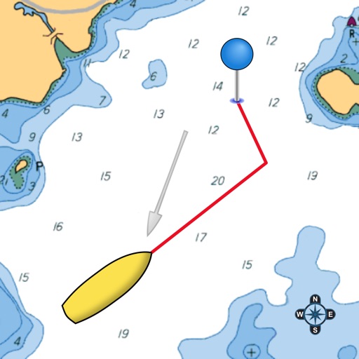
► ROUTES and WAYPOINTS
Plan your trip, insert and edit waypoints. Navigate your route and monitor distance, time (ETA) and direction toward your next waypoint or your final destination.
► ANCHOR ALARM
This function will check in realtime your GPS position against your anchor position previously defined. An acoustic and visual alarm will run as soon as your GPS position is out of the preferred range.
► TIDES & CURRENTS
You can calculate the prediction for more than 6800 stations in the US & Canada. You can also have a simulation of the T&C trend on the map.
► LOADING and SHARING
You can share your favorite's markers on Facebook or send an email with your last daily track. Not only, you can also load any KML, KMZ, GPX (also zipped) found in internet or received from your friends.
► ActiveCaptain
Join the community of more than 100.000 boaters who write reviews, update data and provide up to date hazard information.
Read and contribute reviews and rating about marinas, shared local boating knowledge, anchorage and hazards
► Waterway Guide
Marinas, hazards, anchorages, bridges, free docks and much more to cover the entire US coastline.
► Aqua Map Master
With this subscription you will access a set of advanced functions that will transform your device in a real ChartPlotter (.. and more).
Connect your NMEA (and SignalK) devices through the WiFi and use their data for all the App functions (eg Anchor Alarm), download and display the last USACE surveys, consult the Route Explorer with bridges, hazards and best fuel prices calculation, display the AIS targets on the map with automatic collision detection.
► TYPE OF PURCHASES
- Unlimited: you can download and update your charts forever.
- Subscription: it is a one year auto-renewable subscription, it will automatically renews unless auto-renew is turned off at least 24-hours before the end of the current period. Subscriptions may be managed by the user and auto-renewal may be turned off by going to the user's Account Settings after purchase.
Terms of Service: http://www.globalaquamaps.com/Acknowledge.html
Privacy Policy: http://www.gec-it.com/GEC-privacy.pdf
————
The continuous GPS usage, also in background, can drastically reduce the battery life.
Reviews
GREAT VIEWER!
THE_CRUISER
easy, great look & feel. Thanks for the update! Satellite overlay is appreciated! Please put new features now! I would like to have markers & fishing spots.
Aqua Map USA
Donlyallamuchi
As far as I can tell, this app does not cover the USA inland. In fact, all lakes near NC are blanked out. Other parts of the USA are similarly not covered. I don’t care to navigate the Atlantic or the Great Lakes and feel this was a waste of time and money
More than a backup
TunaCatcher
Just used from Myrtle Beach down to Ft. Lauderdale side by side with my chart plotter … this is more than just a backup, the large iPad screen made this App much more appealing than my old style plotter. Thanks guys
so pro
nguyendaica
this app have a different levels from the others. the graphic and data look so pro and useful for anyone who concerns to the jobs on beach or submarine. highly appreciate apps like this
Such an useful
luquheu
This app is awesome. The information is so detail. Fisher or anyone who works on the marine can be helped with this app. Super useful
Nice
TychoX2
An excellent nautical GPS map that can be used for any number of outdoor activities, including fishing and sailing. One word to the wise, use a waterproof iPad case!
OK
TJSynkral
Seems like a nice idea but it's very annoying having to download map tiles one by one, and the map data is not fully fleshed out.
Not worth the price
Saraths89
Average map app. Not very useful. But only available offline marine map that can track & record marine route. But defiinetly worth shelling out unless you are an avid boat rider/marine traveller. But app is neat with simple interface. Has nautical charts for fishing and sailing.Good design and interface.