RadarScope
| Category | Price | Seller | Device |
|---|---|---|---|
| Weather | $9.99 | Base Velocity, LLC | iPhone, iPad, iPod |
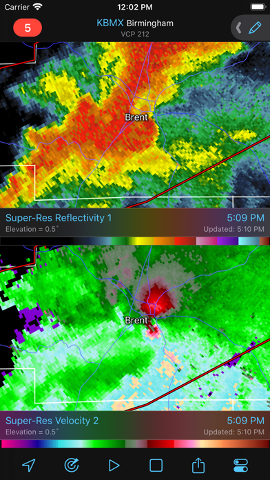
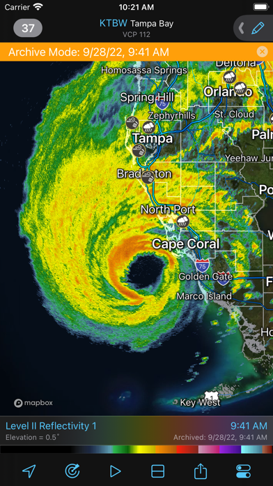
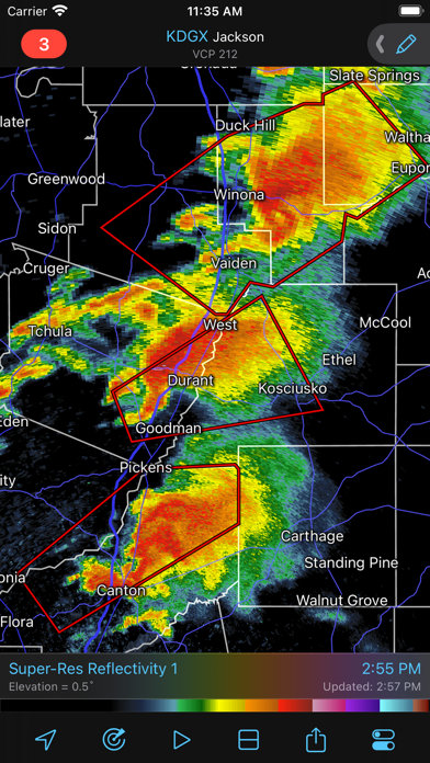
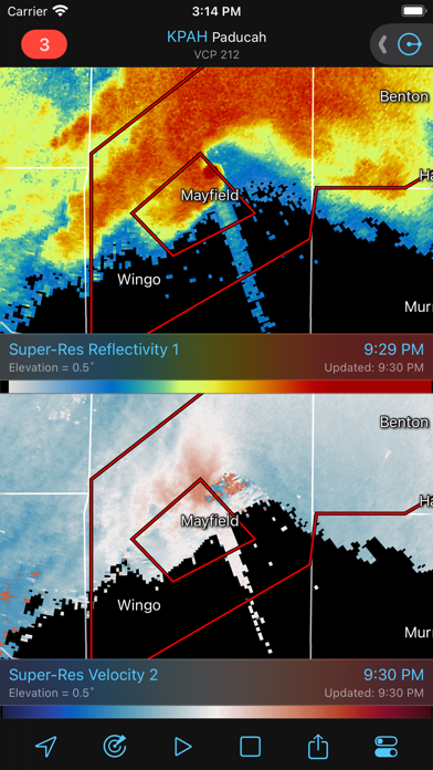
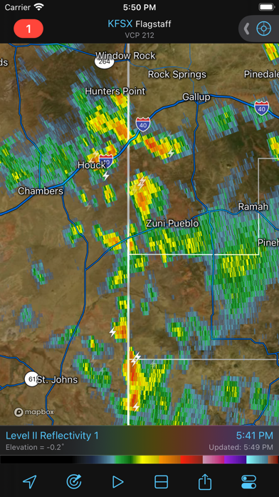
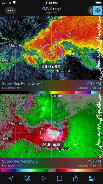
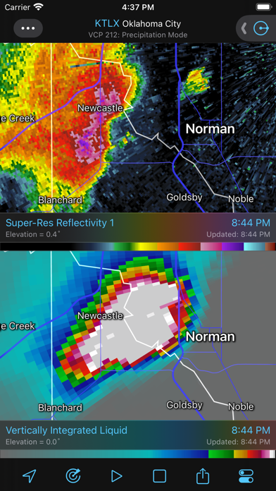
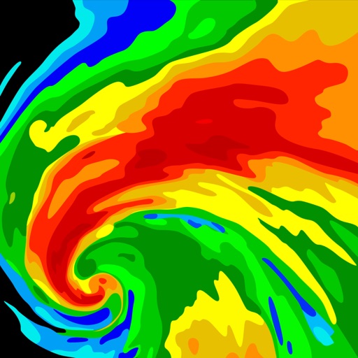
Whether you are scanning reflectivity for a mesocyclone's tell-tale hook echo, trying to pinpoint the landfall of a hurricane's eye wall, or looking for small features like velocity couplets in the storm relative radial velocity product, RadarScope gives you the power to view true radial NEXRAD weather radar on your iOS device.
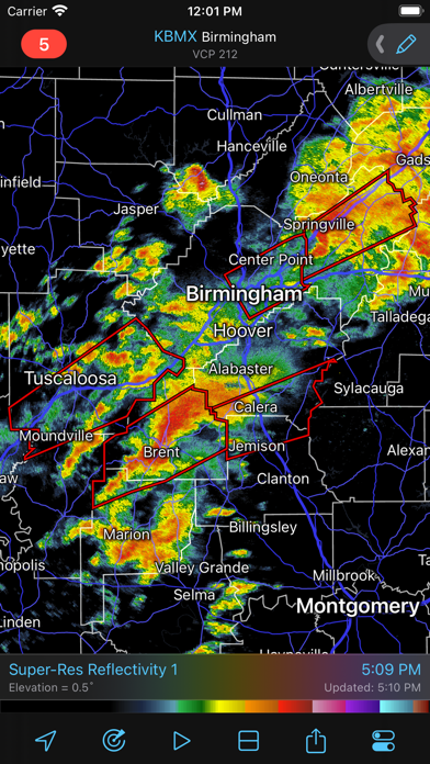
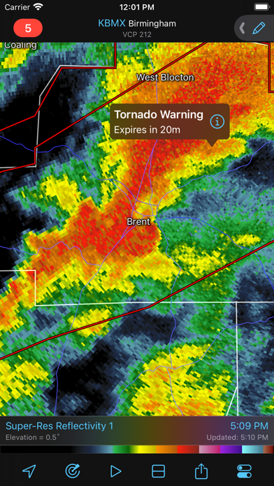
When there are any Tornado Warnings (outlined in RED), Severe Thunderstorm Warnings (YELLOW polygons), or Flash Flood Warnings (GREEN polygons) in effect throughout the US, tap the warning button in the top right corner to browse the list of current warnings, view the details, and even zoom to the selected warning on the map.
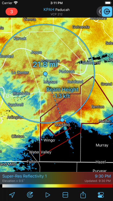
Pinch or stretch to zoom in and out. Drag your finger around the map to scroll. Tap the radar sweep button in the toolbar to switch radars. Select one of the 156 different NEXRAD radar sites and 45 Terminal Doppler radars in the US and 30 other radar sites in Canada, with the rotating radar beam representing each radar's approximate coverage area. Plot your current location by tapping the location button and optionally report it to the Spotter Network. Tap the play button to download and animate over the last six images. Display the names of over 25,000 cities and towns on the map as you zoom and scroll. Tap and hold the color legend to see the data values.
Meanwhile, RadarScope will retrieve and display updated data automatically and intelligently (approximately every 3 to 10 minutes, depending on the radar scan strategy).
You can display data from NOAA's public access web site, our optional WDT feed (the default), or your AllisonHouse subscriber account. Spotter Network members can report their location and view the locations of other spotters.
The RadarScope Pro subscription is an optional add-on data set. It provides access to real lightning data that animates along with the radar loop and up to 20 frames of radar data, including *extended loops* of "Super Res" Level 2 data. Super Res Level 2 data is still available to all RadarScope users without purchasing a subscription.
RadarScope Pro subscribers can also access RadarScope for Apple Watch and a data interrogation tool to quickly determine data values for specific radar pixels.
Please visit our web site for more information.
Reviews
Micro managed
Kazuiv
Very disappointed that the radar is limited to one small area of the map. Was looking for a full scale map coverage radar to track oncoming storm sys. Not awful but so not what i wanted. Waste of 10 bucks ?
Alright
phil_vale
It’s alright but your $9.99 doesn’t get you much...just a radar you can get from several others for no cost. What really puts you off is the subscription price $99.99 for a year...seriously? You got $10 off of me but you better enjoy, for that’s all, ever.
The Greatest Weather App For Meteorologists
Jaredmherman
This app has fundamentally changed the way meteorologists and weather enthusiasts get the rawest radar images for view on mobile devices. You can't get better than this. The only things I would like to be added are the following.. •Cuban radar, so we can view tropical systems moving into the gulf •A cheaper Tier 2 plan, maybe $39.99 a year. $99.99 is just too expensive for students and enthusiasts, or maybe a student discount. •The ability to select multiple radars at once and overlap them into a stitched map. •The ability to download raw data from radars. •More tools, radars, etc. Thanks for all the work you guys do!!
Great app for boaters and fisherman.
flatsrascal
I originally reviewed this app based on the S FLA RADAR (KAMX) being out of service so much. Learned that this was ABSOLUTELY NOT an issue with the app. The RADARSCOPE APP is by far the MOST PROFESSIONAL Radar app available. I use it on my boat in S Florida to detect and track storms while I’m off-shore AND in-shore, so I can head for my dock when I see something growing in size or taking a path that will affect my route or current location. Great app! It is not the app’s fault if the folks running the Miami based radar cannot keep their equipment operational.
Needs a couple more features
TStan97
I love this radar app and it’s by far the best on the market. I have nothing to complain about, however I do wish there was one added feature that would greatly improve it. I enjoy watching the radar and looking at storms even when they’re not near me, especially tornado warned storms. The only problem is when I see the storms, I can only see the general location of the storm with respect to cities. I wish there was a feature that allowed me to see the precise location of where certain storms are. Even if it was just something where I pressed my finger and it pulled up the latitude and longitude coordinates so I could search them. It would make it a lot more enjoyable for me and would help me to know exactly what houses or businesses are being affected rather than general locations. Another feature I would like to see is the ability to change the four quick select radars. I would love to have the choice of what four radars I can choose from when holding down on it. I would especially like to see the super res of reflectivity, velocity, specific differential phase, and correlation coefficient. As of right now, unfortunately I am forced to quick select the ones given and have to scroll a lot for the ones I want to see.
I love it but they shaft you on the windows platform
Svsouthernstar
I love the app on the Apple Platform! Have been a member for atleast 5 years. This year my Mac died and I’m forced to use my work computer which is a Windows platform. I find it absurd that RadarScope charges $30 for the app just so I can pay another $99 for a year of tier 2 membership. This is extremely disappointing that you favor one platform over another just so you can shaft the users.
Can only view one radar at a time
Eli Naeher
I wanted something that would let me look at the national NOAA radar imagery easily. This app only lets you look at a single local radar image at a time. This is made clear in the first sentence of the user guide—but somehow they neglect to mention this pretty important fact in the App Store description. There is no way to learn this until after you’ve shelled out $10.
Amazing Radar App
CaramelTV
This app is totally worth the money. It is great and I highly recommend it.
Great App but Lacks Composite Radar
Crfidjdis
Needs Composite Radar, have been waiting 5 years for it. Fantastic app otherwise
Excellent app
JNECyclist
Our small city (Prospect,KY) disappeared from the map while some small subdivision cities remain.