iTrans DC Metro
| Category | Price | Seller | Device |
|---|---|---|---|
| Navigation | Free | Adam Ernst | iPhone, iPad, iPod |


• Tap any station to see LIVE train departure times, just like the overhead displays in the station.
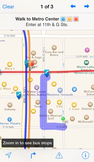
• Use the street map feature to see bus stops and schedules.
• Get step-by-step directions between any two places. iTrans even figures out the best station to walk to and gives you walking directions to the nearest entrance.
• Browse through train schedules for any station. Great for finding that last train on a Saturday night!
• Get push alerts for service disruptions, customized to your line and your commute time. Plus service advisories are saved for offline browsing, so you can browse them when you don't have service.
• Page through the official WMATA system map in beautiful high resolution.
• Street map mode shows you lines and station locations on a street map, along with every entrance and exit to station complexes. Never wander around looking for the stairway again.
This app is for the Washington, DC Metrorail system. Official system map used under license from WMATA.
Reviews
Cannot Even Open the App
Cool Kid 135
This app has previously been helpful to me when navigating in DC. However, the app no longer opens. It will open and then immediately crash. It would be really great if this bug could be fixed because now the app is useless.
Horrible interface
Mojobr
If anyone had the amount of information this app requires to route point A to point B they wouldn’t need the app Somewhat useful as a subway schematic map... Other than that useless
Was good. Now, not so much
kbxm
I’ve used this app a lot in the past, but after the latest update, it’s useless. Any route I try to check either crashes the app, or says “cannot route” with no apparent way to make it work. Stuck using google maps I guess....
Totally missed major delays
Observant Guest
This app is like Metro - great when it works, but fails too often. After a rail in Farragut North broke and a train derailed, this app showed “No advisories” in the next morning’s rush hour. I arrived to work an hour late. At a minimum, a city subway app should communicate major delays in the system.
What the heck happened to the app?
ChefQuelicious
You can’t route anything. If you try to route via subway only you get a warning that you have to add the bus... you add the bus and then the app says you can only do subway. I’m just routing subway station to subway station to get approx route options. Also no alerts coming thru even though the mwata website says there are bus alerts. Was a good app but not sure what’s going on lately. :(
Doesn't work
Jejshsb
Let's me see the metro map which is nice, but can never calculate my trip times or tell me when trains/buses are coming.
Waste of space
Blakellipsis
This app stopped working about a month ago. It was great before, and I was really hoping it would be fixed, but obviously it's not going to be.
Suddenly Stopped Working??
Cbrow142
I've been using this app for years and all of a sudden, it stopped working! Now it says that I have it in Subway Only Mode and when I try to take that off (despite not believing it was ever on), it says I need to try another mode and it basically just bounces me back and forth between different modes while still refusing to work. I'm very disappointed because I really do think this was the best app for DC Metro, looks like I'll have to search elsewhere...
Used to love this app
LauraKKH
I used this app daily to calculate how long I should allow for metro travel to the commuter train. A few weeks ago it started giving me an "unable to route" error message every time I used it. I have deleted and re-installed and still no luck.