Geotag Photos Pro
| Category | Price | Seller | Device |
|---|---|---|---|
| Photo & Video | $3.99 | TappyTaps s.r.o. | iPhone, iPad, iPod |


Rewards:
- Geotagging App of the Year by Macworld
- Repeatedly recommended by leading Adobe Lightroom professionals
- Recommended in many great books such as Lightroom 4 UnMasked, Lightroom 4 the missing FAQ, Lightroom 4 Roadmap for photographers,
- Praised by leading photography magazines and websites all over the world (Techradar, Ephotozine, Fotomaf, Xatakafoto, Lightroom Secrets, Digital-Fotografie, Pixelmania.nl, Photoplus...)
- Note - if you have iOS 8 and newer, you should look at Geotag Photos Pro 2
- See application video at http://bit.ly/9cwRdA
Highlights:
● complete solution - iPhone application for automatic storing of location data & desktop application for geotagging of pictures. No need to purchase another desktop app!
● runs great on background
● battery usage optimised for whole day of geotagging.
● Dropbox support - automatic GPX export of all your trips, makes it super easy to use Geotag Photos with Lightroom
● Smart watch support - free watch app for Apple Watch and Pebble Watch
● export to GPX - 4 ways how to do this: through Dropbox, iTunes, by email or from web. No need to have internet or wifi connection for GPX export!
● Geotagging desktop application - Geotag your JPG or RAW files - quick and easily! Required network connection to get data from iPhone to geotagging app (but no need to have network connection, when you are on the trip). NEW! - complete offline version is also available.
● works perfectly on any operating system - Mac OS X, Windows and even Linux
● supported image formats: jpg, nef, cr2, crw, dcr, ciff, erf, orf, k25, kdc, mef, mrw, nrw, pef, raf, tif, tiff, raw, arw, rw2, srf, sr2, srw, x3f, dng
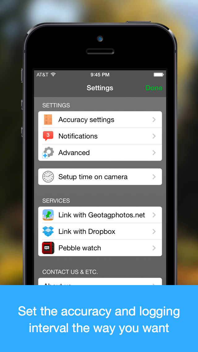
This iPhone app works like GPS Data Logger - it logs your positions during your trip. There are various logging modes, that will fit your needs - continuous mode logs your every change and is best if you need most accurate data, from the other hand time based logging (logs position every few minutes) saves your iPhone battery. Our iPhone app can run perfectly in sleep mode.
When you return from your trip, you can synchronize logged data with our desktop application and geotag photos taken by your camera. We support both amateur cameras (compact) and professional ones (DSLR). We also supports geotagging of various RAW formats (.NEF, CRW, CR2 and others). You can also export your logged data to well known and widely used GPX format - in this new version is NOT NECESSARY to upload data to remote server, you have your GPX files always prepared and can get them using iTunes file sharing function or you can send them from iPhone by email.
few ideas how to use Geotagged photos:
- use Places function of modern viewing applications (iPhoto, Aperture, Picasa) to see your photos on map
- find your photos by place (for example find quickly all photos from New Your in your Photo library)
- upload Geotagged photos to social sites (flickr, ...)
Visit our website for more information! Visit our blog at http://www.geotagphotos.net/blog for news.
FAQ:
q: how much it will drain my battery?
a: depending on logging mode, that you choose. If you choose reasonable logging mode (like to get position every 10 minutes or so), iPhone battery will be enough for more than day.
q: will it work abroad, if I don't have roaming?
a: yes, but it can take longer time before it gets the first position (especially after first usage after your travel by plane). Please don't use Flight mode! It will switch GPS off and logging will not work.
Chat with us on our website, if you have other questions!
Note: Continued use of GPS running in the background can dramatically decrease battery life.
Reviews
Great app. Just one thing....
Jose Oliver
I have been geotagging my photos for a decade using a Garmin Geko handheld GPS. The app is great and the Dropbox integration makes syncing a breeze (I use Geosetter to geotag the photos on my PC). I do miss having the ability to mark waypoints of my shooting locations on the app, otherwise I would give it 5 stars.
Love it!
Schultzp
Love this app. Works beautifully. Only wish the process of adding the geotags to the photos could happen using a tablet/iPad instead of computer. Has anyone figured out how to do this?
Great little app
Panchou73
I use this to track shots and then geotag them later. Much cheaper than buying a dedicated GPS for my DSLR and no wires to deal with.
Terrific
reallyboring
Has been an indispensable part of my workflow for geotagging tens of thousands of photos for years. Uses battery efficiently and records a track that works seamlessly in Lightroom.
¡¡¡Totally Kicks Butt!!!
Mattalones
GeoTag Photos Pro is one of those rare apps that legitimately replaces your need for a $300 device, and it only costs a couple bucks! I almost never pay for apps, but this one makes sense for photographers. Even though many smartphones and low-end cameras have GPS, high-end mirrorless and DSLR cameras usually don't. There are hotshoe attachments that provide GPS, but those start at about $250 for cheap models and go up from there. This little app takes advantage of the GPS you already own: your smartphone. A lot of people don't realize that out phones' GPSs will work without any data or cell reception at all - they do. And this app records the data. It's such a smart thing! I've taken this app to the top of Mt. Machu Pichu in Perú, on the Great Wall of China, to remote waterfalls in Hawaii, and I'm currently on the way to Iceland. It's worked without fail everywhere I've been. Just turn it on and forget about it until you get home. Pro Tip: Set the GPS log frequency so it updates only once every hour or so; otherwise, your battery will only last a few hours. Decreasing the logging frequency will make your phone last a full day even if you use it for other things besides GPS. Highly recommend!
Great app
BrianW222
Not only a great way to geotag photos, but also an easy method of documenting routes taken on walkabouts in cities and countries.
Save some money!
flyjdix11
This is awesome. Why would you buy an expensive GPS receiver that makes your camera bulkier, and drains battery, when you can use this and use the GPS receiver you already have!
Great geotagger!
rk003
Long time user, this is a great app that works with a desktop application to geotag your photos. Syncing support works great and makes this very easy to use! Excited for watch features!!