Terra Map - GPS Hiking maps
| Category | Price | Seller | Device |
|---|---|---|---|
| Navigation | Free | GEC s.r.l. | iPhone, iPad, iPod |


►► Features:
• Optimised for both iPhone and iPad use.
• Amazingly clear maps, thanks to the Retina technology usage.
• Easy to use user interface.
• You can download maps (for FREE) on the device, to be used later without any internet connection.
• Topo Maps for US, Canada, Europe, South America, Asia, Africa, Oceania (the whole world !!!).
• *** NEW *** Expand your horizons with mapXpan (patent pending).
• Share tracks, tours, markers and photos in various formats (KMZ, KML, GPX).
• Share your track together with all the photo taken along in one single file.
• Add the Satellite images as overlay of your map.
• Optimized battery usage with battery monitoring.
• Store your track without the need of cellular data or phone signal.
• Switch between different map colouring.
• Customize your Marker's icon and Track's color.
• Measure distances on the map.
• Load any track, tour and marker from internet communities (KMZ, KML, GPX even if zipped)
• Graph of the elevation profile and speed for each track.
• Search objects around you and around a point selected on map
• Search world places by name
*** NEW ***
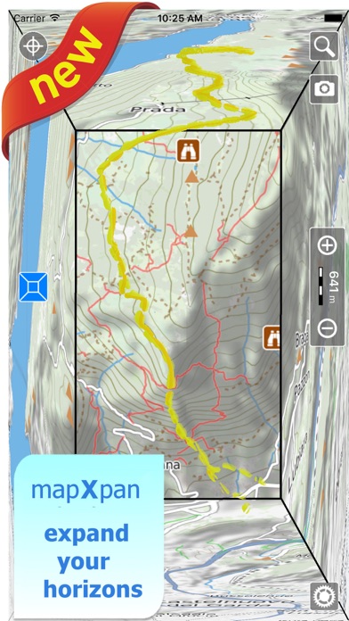
► mapXpan
This new mode will greatly extend your display; you will have the details you need for a safe navigation seamlessly integrated with a large overview area. Using this new mode you will see a map 64 times larger than the standard mode without losing any detail in the center part of the screen.
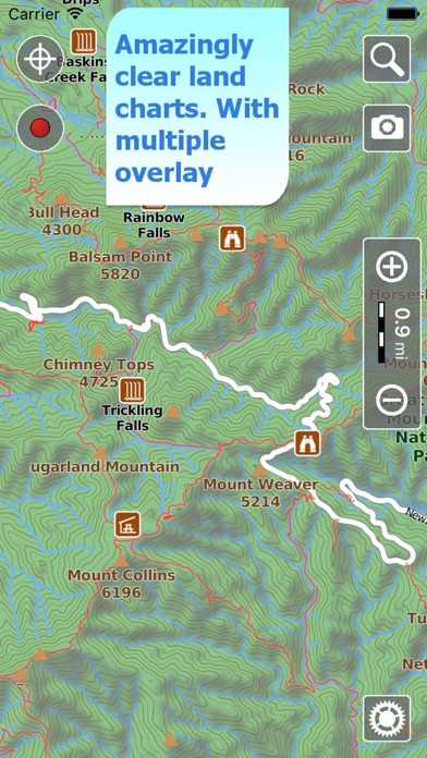
► MAPS
Terra Map lets you download — for FREE !!! — the best topo maps with elevation contours, trails, huts, parks, etc. and no additional purchase is required. You can download the maps at home within your device and then use them without any Internet connection need. Check our maps at: www.globalterramaps.com/terraviewer.html
► SHARING
Why not sharing your favorite markers on Facebook or sending an email with your last daily track, with all the pictures you captured (Note 1) to show them on Google Earth™ or Maps ? With Terra Map it is just a click.
► SEARCH
Search by name of important places worldwide, search of objects around the GPS position or a map position.
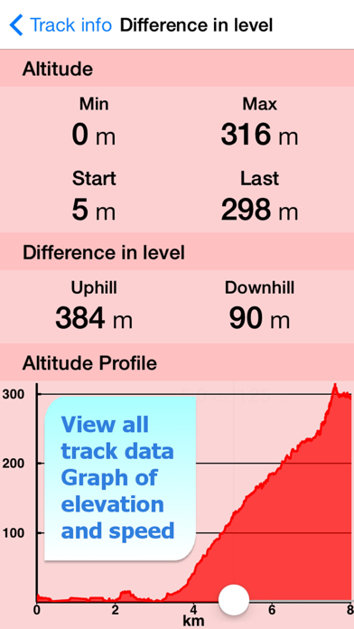
► ELEVATION ANS SPEED GRAPHS
Record all important info of your track and plot the graph of elevation and the graph of the speed.
► OPTIMIZED BATTERY USAGE
Unlike many other apps, Terra Map is designed to use at the best the battery power to last for one full day (Note 2). The Battery Monitoring will stop the track recording when the battery is too low, in order to ensure the phone is still usable at the end of your outdoor's day.
► iOS BACKGROUND MODE
You can record GPS track while Terra Map is in background and while the device is locked.
► TYPE OF PURCHASES
- Unlimited: you can download and update your charts forever.
- Subscription: it is an year auto-renewable subscription, it will automatically renews unless auto-renew is turned off at least 24-hours before the end of the current period. Account will be charged for renewal within 24-hours prior to the end of the current period. Subscriptions may be managed by the user and auto-renewal may be turned off by going to the user's Account Settings after purchase.
Payment will be charged to iTunes Account at confirmation of purchase
Terms of Service: http://www.globalaquamaps.com/Acknowledge.html
Privacy Policy: http://www.gec-it.com/GEC-privacy.pdf
————
Note 1. Pictures captured by Terra Map while recording the track are automatically linked to the track itself, and sent with the track when you share it.
Note 2. The effective battery duration depends by the battery condition, by the temperature and the device usage.
Reviews
Lack of essential func of input GeoCoord
Li-california
After downloaded maps, I tried to search two famous hiking destination but cannot find them. Ok, then I found GeoCoords of them then want to see them in this app, but surprisedly Nowhere you can input them!
Fantastic
Lahtnesornod
I own a fancy Garmin GPS and hike a lot in Colorado. I decided to investigate iPhone-based GPS systems and after some investigation bought two: Terra Map (free and I subsequently upgraded to Pro for $5) and Gaia ($20). So far, I prefer Terra Map for two main reasons. First, their maps are really good. They have combined "layers" for you in a thoughtful manner. The maps are clear and show trails in my area. No single layer in Gaia achieves this and mixing layers is a hassle (and for full offline mixing in Gaia, I think you need the pro version which has a monthly fee). Second, downloading maps for offline usage is a snap in Terra Map. In Gaia, each download is a custom job. Yes, the Terra Map downloads take up about 50MB each, but that is not a big deal with a modern phone. The Terra Map downloads cover pre-defined areas and the areas are large. The downloads contain the beautiful maps fully available for offline usage. With the Pro version, you can download an unlimited number of areas. The interfaces in Terra Maps and Gaia are both good. I suspect Gaia has a few more features, but the clarity of the maps in Terra Maps wins the day. And you can't beat the price. Also, who needs a dedicated GPS device when the iPhone-based devices are so good.
Gotta love offline maps!
mazatzalwoman
This is a nice program as long as you download the maps you need before you are offline. I would give it 5 stars except for the intermittent problem that I am having with it marking my track. Yesterday I thrashed through brush for three hours uphill to mark a fence line, when I got to the top the track hadn't registered even tho the little icon was still flashing as active. Grrrrr!
Excellent maps, easy to use
nkalvi
Good introductory tutorials in both the app and website. Maps are large, but are well detailed; and the download speed is good. Also, maps management is well designed. Possible improvements: Route planning can be improved to take existing trails/tracks into account. Distance calculation is a straight line one; would me more useful if it can follow a path or can have multiple segments.
Artifacts
J-L B
Edit: The developer helped me with this, so I’m raising my rating. Original Rating: “I notice that the maps leave artifacts from the relief when looking at the topo. It’s very annoying.” From the developer message: Hello, we have to keep a limited number of height samples to keep memory occupation acceptable and our library works with a tessellation of images of 256x256 pixels so when the system is zoomed the shading can appear unrealistic. You can switch off the shading using the menu Settings —> Shading We already switch off it automatically at the given some level, we can anticipate the switch off in future releases.
Good app with great support
lostnavigator100
Love this app for being easy to understand and easy to use, plus the maps are very good. I had a problem with OS13 update and the app. Emailed support, and had an answer and fix quickly.