SailTimer™
| Category | Price | Seller | Device |
|---|---|---|---|
| Navigation | $13.99 | SailTimer Inc. | iPhone, iPad, iPod |
Whether for cruising or racing, it is important to be able to determine the best heading on all points of sail. Sailing off the wind increases boat speed but lengthens the distance. Heading too far upwind shortens the distance but reduces speed. To help you select the best heading, SailTimer continuously updates your optimal tacks.
Operating Instructions and Unique Features:
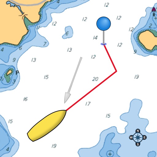
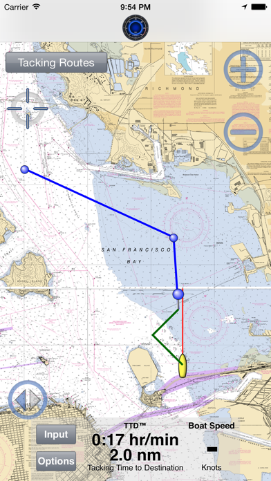
● Save waypoints on the map. Rename them. Then easily display the optimal tacks, tacking distances, headings and times to get to a waypoint.
● If you have our wireless anemometer (www.SailTimerWind.com), the wind direction and speed arrives magically through the air. To see the optimal tacks, there is then only one step: Just enter the waypoint or direction to the waypoint. It is that simple.
● Worldwide vector charts: If you have the Navionics Boating app, you can also use the same charts here with a yearly subscription. Navionics terms of use: SailTimerApp.com/vectorcharts.html . Payment will be charged to iTunes Account at confirmation of purchase. Subscription automatically renews unless auto-renew is turned off in iTunes Account Settings at least 24-hours before the end of the current period. Account will be charged for renewal within 24-hours prior to the end of the current period, with the same cost for renewing the subscription again.
● Marine charts (raster) based on the paper charts are also available as low-cost in-app purchases for USA, UK, Canada, New Zealand, US Virgin Islands, Puerto Rico, and large-scale charts of The Bahamas and Cuba. Aerial photos and road maps worldwide are available free. All can be used offline.
● The white crosshair icon in the top left is the “Follow-Me” button. If clicked, it turns blue and keeps your location in the center of the screen as you move. Unselect when not moving to look around the map, and when you want to zoom in and out.
● If using an anemometer, you can enlarge the Wind Speedometer to keep an eye on wind gusts. Click the Graph button and you can save or share a graph showing your boat speed and wind speed. The graph saves these for up to 24 hours as long as the device is not rebooted.
● Your device will not go to sleep when the app is open, to allow you to continue to monitor your progress on the chart. You can also continue to track your tacking results with the app running in the background or when the device is asleep (unless you hard-quit).
● ActiveCaptain: Click on flags on the chart for comments and reviews about anchorages, marinas and hazards. It is like a cruising guide that never goes out of date.
● Click on the pin at the end of a pair of tacks to see the distances, heading and time on each tack.
● Custom polar plots: The app can learn your unique sailboat's speed profile on all points of sail, for the most accurate tacking results.
● Switch to the port or starboard tack to avoid obstructions, or let the app automatically display the tack nearest to your current heading.
● Overlay under Options for crowd-sourced Live Wind & Race Maps. You only need to log in once, and your login is retained for offline use. Try it out with the demo replay under Options > Events, of AC45 catamarans and wind conditions from the lead-up to the 2013 America's Cup.
● Save, import or email your GPS track.
● Convert from Apparent to True wind speed & direction.
Continued use of GPS running in the background can dramatically decrease battery life. This app may use your location even when it isn’t open, which can decrease device battery life.
Reviews
niall
inyourfacetoo
Rubbish on the ipod touch. Until they allow the current position to be set manually (ie without GPS) it is functionally useless.
No stars
T Vernor
Five Star hype. No stars for substance. The one star is in default to get this review to print. How disappointing. Such a great idea. Maybe it will upgrade someday and I'll have something for my time & $.
Great product
danreich
Great product for the active sailor. I'm eagerly waiting for new wind instrument.
Fantastic app for the sailor
Monkey2457
App is great in that it can interface with existing marine instruments while leveraging what looks to be a great new windspeed and direction device. Can't wait to get my hands on it to test the app and device together!
Quick and easy
Alberta D. Duncant
Lets me see my optimal tacks on a route of waypoints as soon as app opens
The best sailboat navigation
Darlenet99
The tacking functions are easy to use and not available on a GPS from the major manufacturers at much higher prices.
Much better than the old VMG and ETA
Capaincessiont
Optimal tacks based on tacking distances are what I have always needed.
Can plan trips and route in advance
Salogned89
This app lets me check new sailing locations and tide levels wherever I am, then full navigation once I am in the boat.
Its great
Krourstagets
I need True wind angle and speed. When sailing I can’t get that by feeling the wind or looking at a Windex plastic arrow (which only shows Apparent wind angle)