ViewRanger: Hike, Bike or Walk
| Category | Price | Seller | Device |
|---|---|---|---|
| Health & Fitness | Free | Augmentra Ltd | iPhone, iPad, iPod |
Used and trusted by over 200 search and rescue teams.
DOWNLOAD TOPO MAPS
- Global street and terrain mapping from OpenStreetMap® and OpenCycleMap
- Ski piste map, Transport map, Bing Aerial Imagery.
- Purchase the USA topo map for $19.99 and the Canada topo map for just $4.99.
Additional premium topographic maps are also available for Europe and New Zealand.
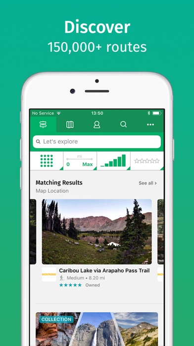
DISCOVER INSPIRING TRAIL GUIDES
- Create and follow your own routes or download routes from our massive library of expert- and community-generated walks and rides.
- Routes are published on ViewRanger by guide book publishers, outdoor brands, tourism agencies, and users like you!
ACCURATE NAVIGATION
- The app has an active route navigation system which uses your phone’s GPS.
- Bearing, distance and estimated time to next waypoint and to end of route, grid references in several formats, spot altitude, altitude gain / loss and navigate to points of interest.
WORKS WITHOUT CELL COVERAGE
- The app uses your cellphone’s GPS, and does not need data or cell coverage to locate you on a map, record your track, or follow a route. Maps are stored on your phone so they work offline.
RECORD YOUR ADVENTURE
- Record your track, see your track live on the map as you advance and share the completed track with friends.
- Add photos to your track along the way from Flickr and Instagram.
- View track stats such as distance, speed, altitude and many more.
SHARE YOUR LOCATION
- BuddyBeacon™ is a unique PIN-protected real-time location sharing and tracking system which allows you to share your location with friends and family.
GO LONGER WITH POWER SAVE MODE
- ViewRanger lasts even longer in power save mode, letting you spend more time out on the trail.
ACCESS VIEWRANGER ON PC & MAC
- View your maps and plot routes in advance on PC or Mac using the route-plotting tools on my.viewranger.com, then synchronize these routes to your phone.
SYNCHRONIZE YOUR DEVICES
- If you want to view your maps, routes and tracks using ViewRanger on another device, or you’ve lost your phone, just log into a new device using your ViewRanger account details and synchronize the app.
APPLE WATCH™
- Navigate your trail and view track stats on your wrist with Apple Watch™.
- Record a new track and pause or stop an existing track recording by using Force Touch.
- Customise the watch app’s interface colour.
APPLE HEALTH
- By accessing your Apple Health data, ViewRanger can give you even more detailed information about your activity, including the number of steps you’ve walked and your heart rate (when using Apple Watch™ or Bluetooth 4.0 enabled devices).
- Tracks recorded from your walks, cycle rides and other activities in ViewRanger can be saved to Apple Health as workouts.
-------------------------------
Enhance your experience with premium features:
PREMIUM OFFLINE TOPO MAPS
- Purchase the USA topo map for $19.99 and the Canada topo map for just $5, in a range of zoomable layers and easily saved for use offline.
- Premium topographic maps are also available for Europe and New Zealand.
-------------------------------
Like us on Facebook or Follow us on Twitter for the latest news and updates:
facebook.com/viewranger
twitter.com/viewranger
SUPPORT
Need more info? visit: http://www.viewranger.com
Support page: http://www.viewranger.com/en-us/support
Any questions or feedback, please drop us an email: [email protected]
OTHER
Free Global maps © OpenStreetMap contributors.
Continued use of GPS running in the background can dramatically decrease battery life.
Some features such as BuddyBeacon, viewing online maps, browsing route suggestions, downloading maps and routes requires an internet connection.
Reviews
Not user friendly.
Wishicouldfindanicknamenotused
Used to be good no no maps can be used. I don’t want an account.
Worthless App
Hugusdamoos
1. App can't find any locations. You search for an address, and a message pop-up reads "Location not found!" 2. I can't find the mountain peak identifier anywhere within this app. 3. User interface extremely unfriendly and confusing. 4. You have to click through three pages of BS offers before you can even get into the app. 5. Moreover, my rule of thumb for apps is if I can't figure them out in 10 minutes, they're history. Not even close in this case. 6. Thank goodness I didn't pay for this jive app. Deleted.
Good tool for tracking bike rides
Ballou778
Excellent tool for bike riders wanting to track time and distance, and preserve mapped route. Great for hikes too.
Not impressed
mvneufeld
I bought this app two days ago, excited to use it with my new Apple Watch. I also bought the USA USGS topo map for $20. My account shows that I’ve been charged for USA topo map, but it doesn’t appear in the app on my phone. I’d try it on my iPad, but the app won’t even open - it immediately crashes, even after deleting and reinstalling. The $20 map doesn’t appear in my account on the ViewRanger website either. It’s just about impossible to contact ViewRanger, and their support is pretty much nonexistent. I am not happy, to say the least.
No compass headings given!
Luvtn
There are no compass headings given. It is difficult to edit a plot or remove it. No wonder I don’t use it much.
Saved my lost self in Iceland.
Bo6384
I use this app to pair with my watch and track distance/altitude. I do long distance primitive backpacking and happened to find myself caught in a complete white out, blown off track, and lost at the top of a glacier in Iceland while doing the Laugavegur Trek to Skógar... Near tears, and with frozen fingers, I was able to use the iPhone app to show me the correct vector to the trail and eventually a hut that allowed me to dry out and warm up for the night before continuing off the glacier. This app saved my life truly.
ViewRanger
Scanner Man 9292
This is the best hiking and outdoor app out there in my opinion. I use it very often for hiking and also to mark hunting stands.
Ok app
RandomUser1111119999
App is clunky and not very intuitive. GPS tracks was way off. Marked trails had me at over 6 miles but my gps tracks showed half that. Also, looking at the gps track it is clear that not enough track points were taken. It looked like I flew over a mountain rather than going on a trail.
Very useful
swright243
I have used this without an account hiking in Massachusetts and Maine on day hikes and overnighters. The compass and maps including trails have been very good and taken the guess work out decisions needed for obscure and even unsigned trails. I have found trails that were left out of state maps. I wouldnt go without it.