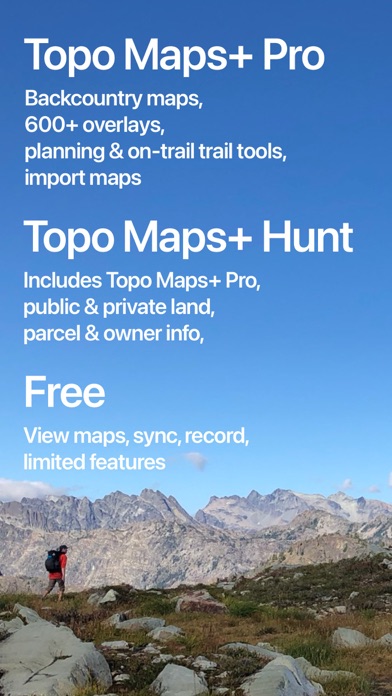
Topo Maps+
| Category | Price | Seller | Device |
|---|---|---|---|
| Navigation | Free | Glacier Peak Studios LLC | iPhone, iPad, iPod |


** Featured Apps for Outdoor Adventures
** Featured Apps for Hiking and Camping
** Featured in Offline Hiking and Travel
** Featured in Get Outside on the App Store Home Page
** Featured Apps for Plan Your Summer Vacation
"Topo Maps+ is your best backcountry companion" -- TUAW (The Unofficial Apple Weblog)
Dream Less, Adventure More! Download Topo maps for offline use while deep in the backcountry.
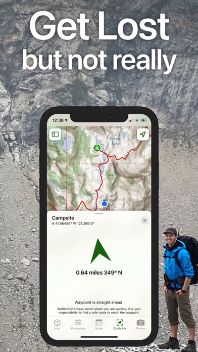
NEVER GET LOST AGAIN
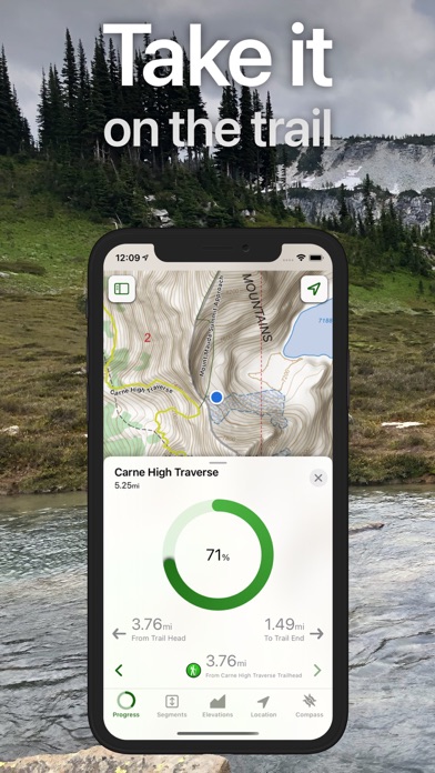
Combine GPS with downloaded USGS, MapBox, NRCAN/GEOBC, and Thunderforest topo maps and you can view you current location on a topo map even when you are at that perfect hidden mountain lake that is days from the nearest the cell tower. Use the GPS and compass on your iPhone to see your current location and to align the map with the direction you are looking.
(GPS and compass work without an internet connection.)
APPLE WATCH SUPPORT
View your offline maps and current location just by glancing down at your wrist. You no longer need to pull your iPhone out of your bag to check your position.
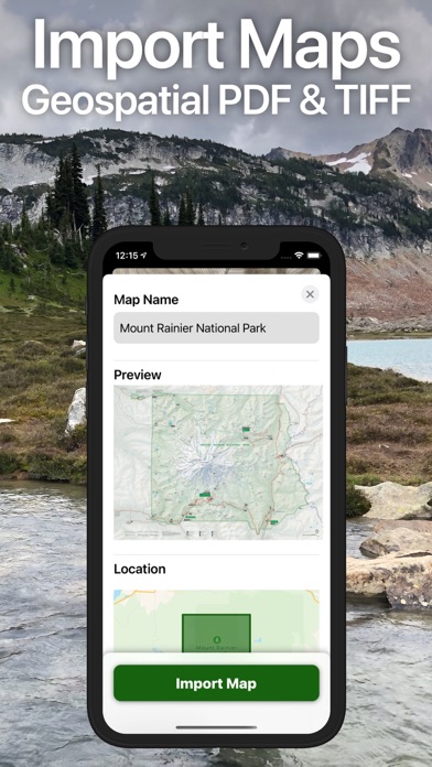
DOWNLOAD MAPS
Easily download USGS, MapBox, NRCAN/GEOBC, Thunderforest, and Satellite maps so you can use the maps offline while deep in the backcountry.
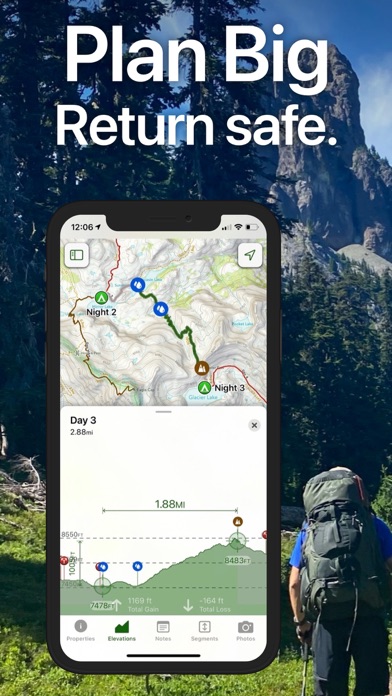
PLAN YOUR NEXT ADVENTURE
Be prepared for that awesome journey through majestic mountains, down flower ladened valleys, and over craggy passes. Trace routes to find approximate distances and elevation profiles between locations. After tracing a route on a topo map you can view that route on the Satellite map.
GORGEOUS MAPS
* Detailed USGS 7.5 minute topo maps for the USA. USGS topo maps are the ultimate map for hiking, backpacking, mountain biking, and other outdoor activities. They have the details you need while in the backcountry.
* Detailed USGS 7.5 minute topo maps with stunning relief shading for the USA. This gorgeous relief shading makes the USGS topo maps much easier to read and use.
* NRCAN/GEOBC topo maps for southern and western Canada.
* Thunderforest outdoor map has contour lines, trail, and outdoor features for the whole world.
* MapBox Outdoor map has world wide hiking and biking trails.
* MapBox Terrain is a beautiful elevation and land-use layer for the entire world, visualizing hills and elevation contour lines.
* MapBox Satellite offers highly-detailed imagery for the whole world.
* MapBox Street map is an ideal map for urban use and getting to the trail head.
* New Zealand Topo Maps from LINZ are the ideal maps for exploring New Zealand.
PLAN
* Download maps for use offline.
* Easily trace routes to find approximate distance between locations.
* Add waypoints to maps.
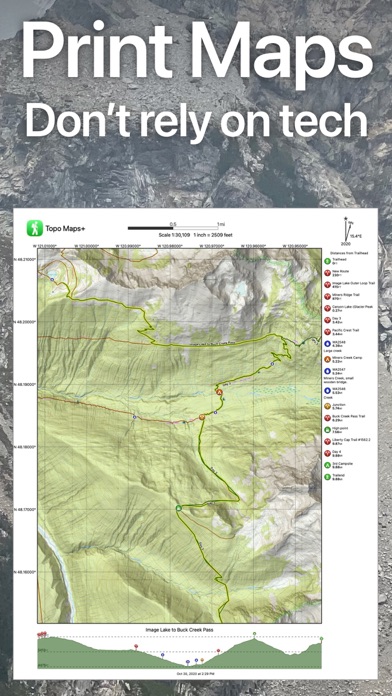
* Print maps just in case something happens to your iOS device. If you don’t have an airprint printer you can email yourself the map and print it from another computer.
* Trace over a trail on a topo map and then visualize that trail with the MapBox terrain and satellite maps.
EXPERIENCE
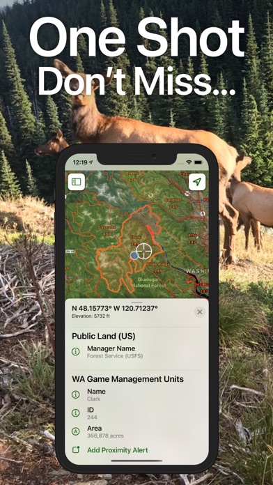
* View your current location on the map, even if you are offline.
* Use the compass to orientate the map so you know which direction to go.
* Record your trip to see your distance, elevation profile, and average speed.
* With downloaded maps you can go deeper and farther into the backcountry without being worried about having an internet connection.
SHARE, IMPORT, & EXPORT
* Share routes, trips, and waypoints with your friends.
* Share custom map images
* Export routes, trips, and waypoints to KML & GPX files to use in other apps.
* Import routes and waypoints from KML or GPX files.
TAGS
* Organize your routes, trips, and waypoints with beautiful tags.
* Share tags with your friends so they can import the data into Topo Maps+ or into another app via a KML or GPX file.
CLOUD
* Sync your routes, trips, and waypoints between all of your iOS devices.
* Sync your map subscriptions between all of your iOS devices.
Continued use of GPS running in the background can dramatically decrease battery life.
Reviews
Absolute Crap
Flyingsurfer
Waste of time unless you want to subscribe at $19 per year. Don’t waste your time
Outdoorsman
NASCAR 29
Don’t waste your time you know the old saying nothing’s free well it’s true here. 1. The free version is so blurry I couldn’t even read what a road name that went on though a wildlife management area or even the names of main creeks in a area 2. When downloading a map the sections are super small as well.
Great customer service
kettle moraine hiker
Have been using this app for a few years now and always been happy with it. Just had an issue where my iPad and IPhone were not syncing and then my login stopped working. Contacted support by email and had a response in an hour or two. Spent most of the following day emailing back and forth with Danny and now everything is working as it should. That is dedicated and friendly support.
Awesome!
MikeLebo
I mainly got this to use with my mac for creating routes/tracks. Both the iOS and Mac versions are awesome! Very impressed and I’ve used many other apps. Service is top notch as well. I had a few questions after purchasing the Mac pro version and got a response within a couple minutes...wow just awesome!
Not good anymore
Hprlflgkdkck
I have used this app for some years now and it recently started being very glitchy. It is very slow to load even at home with all the WiFi and cellphone strong signals. I will cancel my subscription. I do not recommend anymore.
Casual Appalachian hiker
imsickoftryingtopickadammane
Decided to go ahead and purchase Topo Maps + Pro after using free version for a little while. I couldn’t be more pleased; I think it is well worth the subscription. Numerous map options. ‘Natural Atlas’ is the one I use the most. Many features and they all seem to work well. Also, the printing feature works well and I just have a regular H&P printer from Wal Mart. The developers send out regular email tutorials too which help, but overall I would say most of the features are pretty intuitive. Thanks!
Best Hiking Maps App
Electro.Shock
The details that can be found on the “Natural Atlas” basemap are far better than any other map available. Pair that with an awesome way to pre-download maps before you head to the trail. This app is what you’re looking for! The only thing it lacks is the ability to view the maps on a computer, unless you have a Mac. My suggestion here would be for them to create a web based service that is accessible from any desktop or laptop regardless of operating system. Source: 2-Year Subscriber, happy customer.
Great Service
Andy West Yellowstone
I could not believe that I received a text reply in only minutes. I was experiencing an issue last hunting season, they responded, I’m happy. I love this app. Today (4/40/20) I had another question about certain phones working with GPS. Again, quick reply. Great people.