i-Boating: Marine Charts & Gps
| Category | Price | Seller | Device |
|---|---|---|---|
| Navigation | Free | Bist LLC | iPhone, iPad, iPod |
Europe Rivers (Danube,Drava,Rhein etc). Coverage includes NOAA marine vector
charts,freshwater lake maps,USACE inland river maps (HD/1ft/3ft bathymetry
included where available),charts derived from UKHO & CHS data. First marine GPS app to have route assistance with Voice Prompts for marine navigation. You can create new boating routes or import existing GPX/KML routes. It supports Nautical Charts course up orientation. Includes Tide & Currents prediction.
►FEATURES
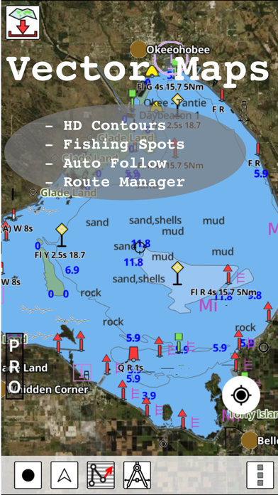
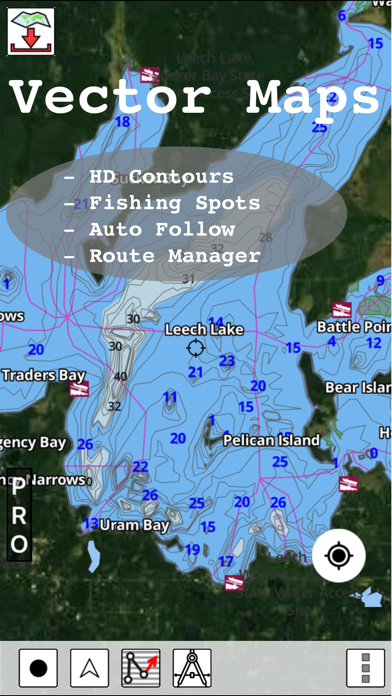
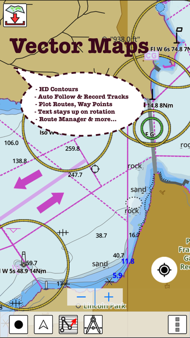
√ Beautiful & detailed Hardware/GPU accelerated vector charts (text stays upright on rotation)
√ Long press to query the details of Marine object (Buoy,Lights,Obstruction etc).
√ Customizable depth(Ft/Fathom/Meter) & distance units(km/mi/NM)
√ Customizable Shallow Depth.
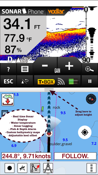
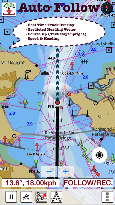
√ Record tracks,Autofollow with real-time track overlay & predicted path vector.
√ Voice Prompts for marine navigation (requires GPS )
√ 1ft / 3ft depth contour maps for anglers for selected lake maps.
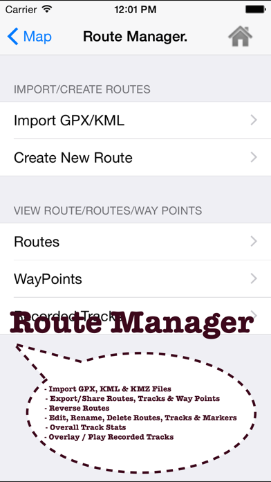
√ Supports GPX/KML for boating route editing/import.
√ Tide & Currents prediction.
√ Seamless chart quilting of marine charts
√ Enter or import Waypoints.
► MAPS
It includes unlimited updates for 1 year.
√USA: The maps include coverage of all NOAA marine vector charts (ENC),USACE inland river maps,freshwater lake maps for more than 7K lakes. The charts include HD/1ft/3ft bathymetry where available.Incl. NOAA raster where ENC not available.
√Canada:Incl. CHS data(incl. major Lakes).
√UK/Ireland: Derived from UKHO charts.
√Australia
√Germany: All BSH Charts.
√Europe Inland Rivers:Donau/Dunaja,Rhine,Garonne,Moselle,Drava,Sava,etc
√Norway
√Finland
√Sweden
√Croatia
√Ukraine(Black Sea)
√Caribbean
√New Zealand
√Spain
√Brazil
√Argentina
√Cyprus
√Falklands
√Seychelles& Mauritius
√Denmark
√Malta,Cyprus & S. Mediterranean
√S. China&Malaysia
√South Africa
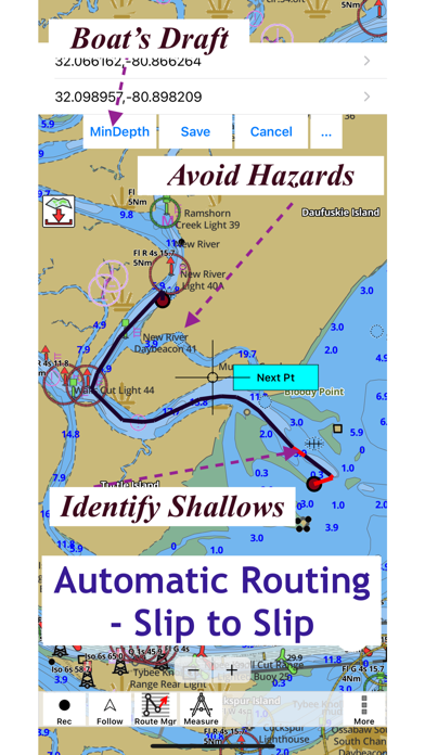
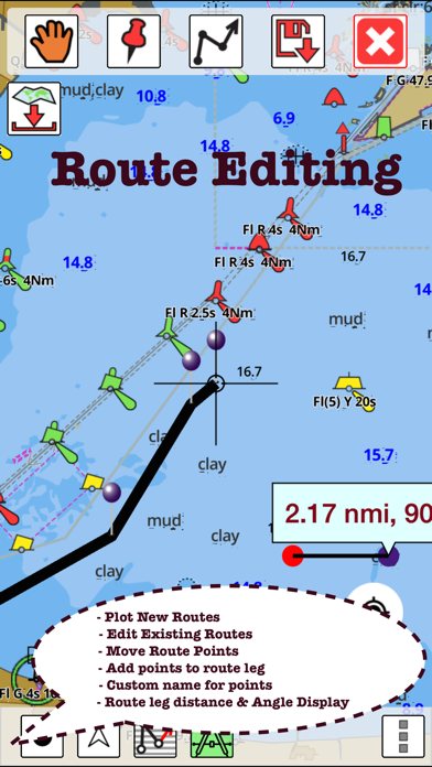
►ROUTE MANAGEMENT / TRIP PLANNING
√ Create New Route/Edit Existing Routes
√ Move Points
√ Add points to an existing route leg
√ Delete / Rename points
√ Import GPX,KML & KMZ files
√ Plot/Edit Routes
√ Enter Waypoints
√ Share/Export Routes,Tracks&Markers
√ Reverse Routes
►GPS FEATURES
√ Auto Follow
* Real Time Track Overlay
* Predicted Path Vector
* Course Up(Text stays upright)
* Speed & Heading
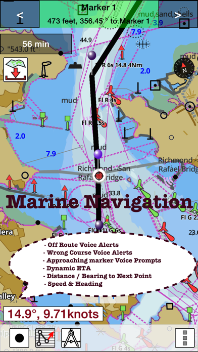
√ Route Assistance With Voice Prompts
* Prompts when approaching a boating route marker
* Continous distance & ETA updates
* Alerts when sailing/boating off route
* Alerts when boating in wrong direction
√ Record Tracks
►TIDE & CURRENTS
* For US, Canada, UK, Germany & New Zealand
* High/Low Tides
* Tidal Current Prediction
* Active Current Stations
► SHARING
* Share tracks/routes/markers on Facebook & Twitter
* Export tracks/routes/markers as compressed GPX files.
Sample Charts
SUGARLOAF KEY-KEY WEST
PORT RICHEY TAMPA BAY - CLEARWATER HBR
EAST BAY-WEST BAY FLORIDA
ST JOSEPH,ST ANDREW BAYS
INTRACOASTAL WATERWAY MATECUMBE-GRASSY KEY
CHESAPEAKE BAY CAPE CHARLES-NORFOLK HARBOR
ANCLOTE KEYS-CRYSTAL RIVER
ST JOSEPH SOUND
MIAMI HARBOR
Minnesota lakes - Kabetogama,Minnetonka,Waconia,Leech,Mille Lacs
Lake Keowee,Jocassee,Hartwell,Greenwood,Lake Murray
Mark Twain,Ozarks,Table Rock
Lake St.Clair
Lake Kentucky
KEY WEST-THE MISSISSIPPI RIVER
SAN PEDRO CHANNEL
LAKE MICHIGAN STONY LAKE-POINT BETSIE
APALACHICOLA BAY-CAPE SAN BLAS
EAST CAPE-MORMON KEY
CAPE HENLOPEN-INDIAN RIVER
CHESAPEAKE BAY CAPE HENRY-THIMBLE SHOAL LIGHT
DULUTH-SUPERIOR
MONHEGAN ISLAND-CAPE ELIZABETH
ONTARIO - CLAYTON-FALSE DUCKS ISL
Winnipesaukee
MIAMI-MARATHON,FLORIDA BAY
CAPE MAY-FENWICK ISLAND
MISSISSIPPI RIVER-GALVESTON
CAPE CANAVERAL-KEY WEST
DELAWARE RIVER WILMINGTON-PHILADELPHIA
FLORIDA KEYS SOMBRERO KEY-SAND KEY
SAN PABLO BAY
RAINY LAKE BIG ISLAND MINN-OAKPOINT ISL ONT
INTRACOASTAL WATERWAY - BISCAYNE BAY
EVERGLADES NTL PARK - SHARK RVR-LOSTMANS
HURON
TAHOE
CHESAPEAKE DELAWARE CANAL
PLEASE NOTE: Continued use of GPS running in the background can dramatically decrease battery life.
Reviews
Very disappointed
CAT117
I thought this seemed like perfect app for me since I take my boat all over to many lakes in my home state and other states, some far away. So I paid for the upgrade to get all US LAKES. And that was last week. Then this weekend we decided to go boating on the chain of lakes. So imagine my surprise when the app doesn’t even know the lakes exist. I thought ok I’m sure it will work once we get to a larger lake on the chain. Nope. Shows the boat on dry land. So I’m not happy. Wasted $20 for maps that don’t even know that some of the lakes I want to go on exist. I know that there are GPS units that have inland lake maps for pretty much every boatable lake but this app with US lakes is not it. Sorry for rating. I wanted this to be GREAT and thought it would be.
Very disappointed
GO_MOUNTAINEERS
Bought the USA maps and there is a big blank area which just so happens to cover the two lakes I fish most. They are listed on the lake list, this is why I bought it. This app is useless to me, I’d like to get my money back for that no count map.
Missing a big lake
not happy boater
I bought this app to help me on my vacation with Walloon Lake in northern Michigan and it is not on any chard’s! It’s a huge and very well known lake. I don’t understand how this is not available on your app. I would not bought this app if I would have known that this is not a complete representation of lakes .....
Seriously useless with out a legend.
Curtis.ramirez
This app really needs a legend. Somewhat useful but not enough to rely on going offshore to fish.
Includes lake contour maps
vivekboat
This app includes both HD lake contour maps and coastal navigation charts. Maps are all vector and respond very well to touch. Moving map gps auto follow is a toggle button. The best part is that it shows the path one has taken with a dark line and where you are headed with dotted line. Easy to share your tracks and routes with others as gpx files.
Not user friendly
North Miami Boater
There is no explanation of how to create a waypoint. App doesn’t seem to work well with iPad. Have not found any tutorials on how to use it. Can someone help, please?
No support, can’t restore purchases from the App Store. Don’t buy.
Me22321
The product is ok and would have gotten more stars from me - until I needed tech support. I needed to restore my purchases from the App Store and the “restore” button in the app does nothing. Three e-mails later to the only point of contact available from the developer’s website and - nothing. Not even an auto-generated reply. The restore purchases function simply doesn’t work - so unless you are the perfect iHuman and never need to restore a purchase, stay away from this app!!!