
Map Pilot for DJI
| Category | Price | Seller | Device |
|---|---|---|---|
| Utilities | $9.99 | Automotive Data Research | iPhone, iPad, iPod |
Process unlimited jobs of up to 104 images for free with Maps Made Easy.
View Documentation: http://support.dronesmadeeasy.com
Define the area, select the level of detail, and go.
Features:
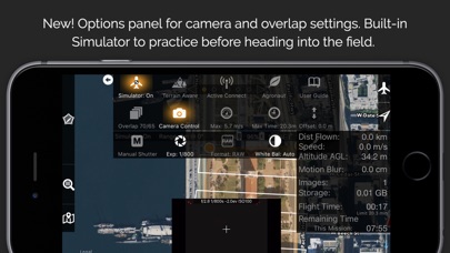
Terrain Awareness
Multi-Flight Coordination
Multi-Battery Management
Automatic, Shutter Priority and Manual Exposure Modes
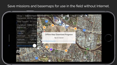
Basemap Caching for Offline Operations
Connectionless Camera Triggering
External Map Data and Markers via MapBox
Terrain Aware Image Footprint Display
Save/Edit Missions
Refly Saved Missions
View 3D logs on-device with Google Earth
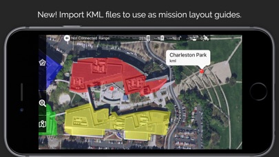
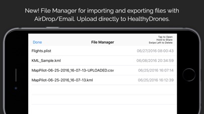
Import KML via Email or AirDrop
Export KML, log files, and Flights file via Email or AirDrop
Flight Log review
Built-in Simulator for testing
HealthyDrones upload from Log File Manager
RAW imaging available via In App Purchase
Fullest Possible Use of Each Battery
Appropriate Camera Triggering
Overlap Management
Speed Management
Automatic Takeoff and Landing
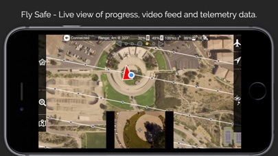
Live Video Preview (large and small)
Signal Quality Warning
Line of Sight Indicator
Automatically Captures Elevation Reference Image (Ground Image)
Natural Landing Assistance
Live Map View
Compatible with iOS 8, iOS 9, and iOS 10.
Supported Aircraft:
Phantom 4
Mavic Pro
Phantom 3 Professional
Phantom 3 Advanced
Phantom 3 Standard
Inspire 1
Inspire 1 Pro
Matrice M100
Matrice M600
Reviews
GREAT App and stitching service for Price
Powers111
I have worked with every photogrammetry app/software for aerial mapping in the past 5 years and for quick, quality maps, I always use Maps Made Easy. Sure, there are ones that achieve better results. But for example, I helped the company Geodetics build their GEO-MMS Velodyne LiDAR system on a M600. It took about 6 months to build/test/analyze the system then another 6 to perfect it. Now they sell for six figures. Plus you have to do all the stitching/texturizing yourself. MME isn’t going to give you a perfect map, it’s not built for it NOR is it priced for that. Keep that in mind, and say thank you every time they stitch the map and give you 10 different files including OBJ.
Mavic 2 Pro NOT supported
DaneTheGeographer
This application does not...I repeat...DOES NOT work with mavic 2 pro. This application would not let me take off or connect to the mavic. It would not allow me to upload the flight plan because the batteries were not sufficient. I have more then one battery, let me program it accordingly instead of making out at 25 min flight time! Over all this app is useless to me and my needs but at least I bought both versions in hopes one would actually work. They don’t.
Professional solution
z3planners
This is the only solution for flying with elevation control. Works very well in mountainous terrain. I use the linear mission regularly. It allows me to profile a road by defining the centerline. A recent IOS update caused problems but the support was quick and efficient and personal. I give this my highest recommendation. For engineering aerial photogrammetry this is the very best program.
App crashed mid flight. Twice!
Strooper
I’m flying a DJI Mavic 2 Pro, my phone is an iPhone X, using the stock Mavic 2 controller lightning cable, and I had no apps running in the background. Sent my Map Pilot project to the drone for the first time today (had terrain data on.) Within 30 seconds the app closed/crashed and my drone was flying the route like a zombie. Relaunched the app and it showed the zombie on its way with no photos being taken. Thankfully I had looked up how to take back control of the drone earlier (cycle the controller switch to sport mode and back to regular mode) then opened the reliable dji app and flew it back. I changed the battery, reloaded the mission and off it went, then the same thing happened this time within 15 seconds. Ugh Update: iOS was fully updated at the time running version 12.1.4
Cannot control app
markj68
I was using this app a lot but lately it seem to not be working as well as it once did. I use to be able to move the direction of the path it would fly but now I cannot. Then there is the issue with it just stopping for no reason and going into a hover. What has happened? It was once so great not it is not so dependable.
Keep away from it.
서울늦둥이
9 out of 10 times it fails to properly connect video feed to DJI Mavic Air. Cannot believe that I paid to waste my time and energy to trying. User interface is so slow on my iPhone 8+ and out right confusing. Don't bother to try. My suffering is enough.