Map Pilot for DJI - Business
| Category | Price | Seller | Device |
|---|---|---|---|
| Utilities | $39.99 | Automotive Data Research | iPhone, iPad, iPod |


Map Pilot Business is offered with volume discounts for large institutional purchases through the Apple Volume Purchase Program. (Minimum 10)
This version will get more expensive over time as IAP options are added to Map Pilot. Map Pilot Business will have access to all future features added in Map Pilot for DJI with no additional update charges.
Map Pilot helps you create and fly the optimal flight path to create great maps using the Maps Made Easy map processing service. Collecting great data to create high resolution aerial maps with your DJI flying camera is just a few clicks away. Process into the final product using your own photogrammetry software or our Maps Made Easy online service. Mapping has never been easier.
Process unlimited jobs of up to 104 images for free with Maps Made Easy.
View Documentation: http://support.dronesmadeeasy.com
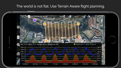
Define the area, select the level of detail, and go.
Features:
Terrain Awareness
Multi-Pass Linear Mission Planning
Multi-Flight Coordination
Multi-Battery Management
Automatic, Shutter Priority and Manual Exposure Modes
Basemap Caching for Offline Operations
Connectionless Camera Triggering
External Map Data and Markers via MapBox
Terrain Aware Image Footprint Display
Save/Edit Missions
Refly Saved Missions
View 3D logs on-device with Google Earth
Import KML via Email or AirDrop
Export KML, log files, and Flights file via Email or AirDrop
Flight Log review
Built-in Simulator for testing
HealthyDrones upload from Log File Manager
RAW imaging available via In App Purchase
Fullest Possible Use of Each Battery
Appropriate Camera Triggering
Overlap Management
Speed Management
Automatic Takeoff and Landing
Live Video Preview (large and small)
Signal Quality Warning
Line of Sight Indicator
Automatically Captures Elevation Reference Image (Ground Image)
Natural Landing Assistance
Live Map View
Compatible with iOS 8, iOS 9, and iOS 10.
Supported Aircraft:
Inspire 2
Phantom 4 Pro
Phantom 4
Mavic Pro
Phantom 3 Professional
Phantom 3 Advanced
Phantom 3 Standard
Inspire 1
Inspire 1 Pro
Matrice M100
Matrice M600
Reviews
Does not work
S Connolly
It is nearly impossible to create a flight map. Extremely buggy. Hopefully it gets a much needed update.
Great results with my P4P and Matrice 100
Volare Aerial Imaging
I have tested this flight app with both my Phantom 4 Pro and Matrice 100 for planning autonomous mapping flights for construction progress monitoring and agricultural mapping. I really value the terrain elevation adjustment function when mapping sloped vineyards. Highly recommend!
The best for autonomous mapping
Gopher19812
This is my premier go-to app for autonomous mapping applications. I have used this app for 6 months now on dozens of missions. Also tried pretty much every other option out there by now. Yes, most other options cost less or are even free. I found some of these other options perfectly usable for professional applications. Why the best? First of all, it’s stable. That seems like a no-brainer for a pilot app of all things, but I had stability issues with several other mapping apps. One wouldn’t even open on my phone, others would crash mid-flight (app, not the UAS). The other reason are features, including safety features. UAV Position and mission progress are shown on a map (another app doesn’t show current position). Only app with a direction indicator to the UAV. Very helpful for relocating when loosing track of UAV. Take-off is when you tell UAV to take off, not as soon as mission is uploaded. Flying multi-battery missions, resuming after an interruption, works better and is more flexible than in any other app. No other app adjusts flight speed based on available light. Yes, you can check blur for yourself, and you should. I’ve flown missions with other apps, only to find after the fact that images are not as sharp as they should be. Never happened with Map Pilot yet. Other unique features: continue beyond radio contact, if you choose to do so (not recommended, may be illegal, depending on where you live). Follow terrain, rather than stay at constant elevation above take-off point (including a warning when this may be a bad idea). Works on both, iPad and iPhone. iPad is obviously preferable, but it’s great to have options. I often work in remote locations, so caching maps is important. Not all other apps do this or do this well. Customer service is quick, helpful, and competent. I have no experience with customer service from the other companies. Why did I try all these other options and not settle for Map Pilot from the beginning? Why only 4 stars? I don’t usually give 5 stars unless things are absolutely perfect and nobody is perfect. The following features I like better in the competition: planning a mission on a desktop and automatic syncing between devices would be nice. You can share missions with Map Pilot, but it’s more cumbersome. Polygon, instead/in addition to convex hull missions would be nice (in one case of an odd-shaped Island, it was a requirement for me). Exposure control interface works, but could be more intuitive. This app isn’t free, but well worth it for the professional feature set and peace of mind.
Great app but needs more camera options
haycanz
Great app, but can you add DJI x7 camera to your list so I can use this camera and get the right overlap. Thanks
Waste of money
Stayxsie
They only support a very small number of imagers, and no way to create your own sensor profile, making the app entirely unusable....don't waste your money. Spoke to customer service....they lied to me, tried to tell me the sensor I was using is very low quality, I should buy one of theirs. Won't EVER do business with this crooked business.
Excellent autonomous flight planner for mapping
mikoontz
I’ve been using Map Pilot for several months to create autonomous missions over forested mountainous terrain. I process these images in Pix4D to generate RGB orthomosaics, digital surface models, 3D point clouds, and multispectral orthomosaics for forest research (so I can’t comment on the Maps Made Easy image processing) The flight planning app works well, with some occasional quirks. It is far superior to other autonomous flight planning software that I’ve used (DroneDeploy and Pix4D Capture, though maybe the last 3 months of updates to those apps have improved them). The multi battery missions work well and the terrain awareness works like a dream. I’ve flown autonomous missions with over 800 feet of elevation change across the surveyed area and the app keeps my drone rolling right over the terrain at a specified altitude above ground level with no problem. Offline support works well, and most of my missions are in spotty cell phone coverage. Enough surrounding base map is cached that I can adjust the flight plan on site if needed. It uses a lot of iPad battery, which I’m told is because DJI’s SDK has recently turned on a bunch of background data logging that can’t be turned off. I’m currently seeking a solution to this, as my iPad mini 4 battery runs out after a few hours of flight time. Really happy with this app so far, and looking forward to future improvements.
Great app, but...
Lczz2
The app seems to be very useful, and it promises a lot of features. Their web site is rich with instructions and examples, which is more than can be said about other developers. So, why only 3 stars? It’s primarily because of their advertising. In the AppStore they state “Process unlimited jobs of up to 104 images for free with Maps Made Easy.” However in the app itself that number is then reduced to 50 or 60. It just makes you feel like you’ve been taken, especially at this price level.
Please refund
Office jerk 100%
Sorry guys this app is not worth the money i compared it to a few others and it is not matching up. I would like to see about getting a refund