Flyover Country
| Category | Price | Seller | Device |
|---|---|---|---|
| Travel | Free | Regents of the University of Minnesota | iPhone, iPad, iPod |

**GPS functionality is only possible from the window seat and GPS reception quality varies by device/conditions**
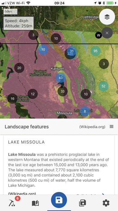
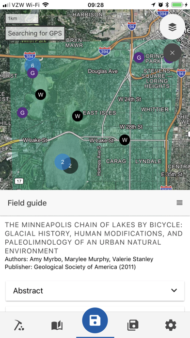
Learn about the world along the path of your flight, hike, or road trip with GPS tracking. Offline geologic maps and interactive points of interest reveal the locations of fossils, core samples, and georeferenced Wikipedia articles visible from your airplane window seat, road trip, or hiking trail vista.
Follow Flyover Country for updates and photos from the sky!
https://www.facebook.com/flyovercountryapp/
https://twitter.com/flyovergeo/
https://www.instagram.com/flyovergeo/
http://fc.umn.edu/
Submit issues, suggestions, and comments via Google Forms http://goo.gl/forms/Yhw9AvMcbTOHTZCf1
Flyover Country is a National Science Foundation funded offline mobile app for geoscience outreach and data discovery. The app exposes interactive geologic maps from Macrostrat.org, fossil localities from Neotomadb.org and Paleobiodb.org, Wikipedia articles, offline base maps, and the user’s current GPS determined location, altitude, speed, and heading. The app analyzes a given flight path and caches relevant map data and points of interest (POI), and displays these data during the flight, without in flight wifi. By downloading only the data relevant to a particular flightpath, cache sizes remain reasonable, allowing for a robust experience without an internet connection.
Flyover Country is not limited to the window seat of airplanes. It is also ideal for road trips, hiking, and other outdoor activities such as field trips and geologic field work.
How to use FC:
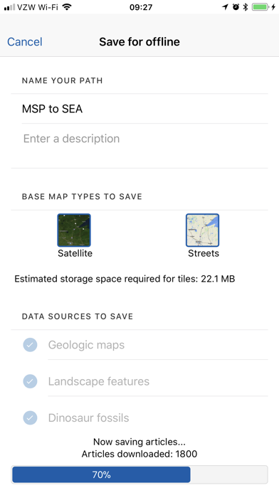
-Tap two or more points on the map to specify your path, then click 'Load path' in the top right corner to view the data associated with the path. Select 'Save for offline' to store the data and associated articles on your device for offline use. Access saved paths from the 'Saved' menu.
-While moving, press the arrow in the lower right-hand corner of the screen to enable navigation mode. This will lock the screen to your position and orient the map to your direction of travel. Press this button again to exit this mode if you need to pan around the map.
-You may also select your 'Trip mode' from the side menu. the 'plane' provides a wide strip of data while 'car/foot' provides a narrower but more detailed geologic map with detailed unit descriptions and metadata.
Please report any bugs to Shane at Loeff081 at d.umn.edu
Warning: Continued use of GPS running in the background can dramatically decrease battery life. Please turn off navigation mode when not in use.
Reviews
So much fun on long flights
NitNicked in LA
Is that really the Grand Canyon below? What are those oddly patterned little roads? Is that mountain below a volcano? Get this app and find out! Download & save maps before you go: you can use the app with GPS even airplane mode with WiFi off.
Really useful
Zupplemental
This app is even better than I thought it was going to be. The info it gives you is super detailed. Takes a little getting used to. I can't wait to use it on my next flight. But I will use it later today on a hike.
Great position tracking on plane
IHateThisReviewSystem
I was looking for an app that tracks the plane location via GPS on domestic flights, and this app does that very reliably. It gives you location, speed, and altitude. There's also a host of other info but I haven't looked at that yet. Unfortunately there's no option to save the entire US or world map offline, but pre-loading the flight path is as easy as clicking on two points on the map. Overall really good app, tested on four domestic flights, worked flawlessly, though it sometimes takes a minute to get a GPS lock.
Unrefined and counter-intuitive
AussieSteveGuy
Awkward to set route. Should be able to enter flight info and have it plot accordingly. Uninstalled.
Doesn't work
Creoletexan
Once I hit "Load Path" if just acts like it's loading data but it never does..... Ancient interface.
Great for a version 0.X
KingArthurVI
I downloaded this app during a trip as recommended by a friend. It does what it promised to, though the path loading does take a while but it eventually finishes. One thing to realize is that app consumers nowadays demand high quality and very well-designed UX and UI, if that can be improved upon then this certainly makes the app 5-star worthy. Great work!
Works as intended
Nerdybails
Opened app and did the very intuitive tap one place then another and it put a nice wide path of data between locations. Depends heavily on your internet speeds to load the data in a reasonable amount of time. The one suggestion I agree with is pulling flight path data, since planes fly a "great circle" rather than a straight line on long flights.
At last!
Gekkosan
Love this! Every time I get on a plane and have the chance to look down, I wonder about the things I can see. Finally there's an app for this too! Wonder why it took so long for someone to come up with it.
Doesn't work for Australia
Appreciative.user
Was excited to learn about this app with my upcoming trip to Australia fast approaching. I went in to load my map and Australia can't be selected as a start or end point. If this only works in the us, make the map a us map. Very disappointed.