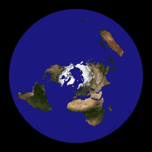
Flat Earth - Satellite Image Viewer
| Category | Price | Seller | Device |
|---|---|---|---|
| Navigation | Free | Tomoyuki Seno | iPhone, iPad, iPod |


Directions:
Double tap: Move the center of projection.
Pan: Translate maps (only in the translation mode). Revolve maps around the center of projection (only in the rotation mode).
Pinch: Zoom in or zoom out on maps (only in the translation mode).
The button on the left side of the toolbar: Switch between the translation and the rotation mode.
Long Press on the map: Display the shortest path between the center and the long-pressed point. Also, calculate the azimuth clockwise from North and the distance between these points, and show them in a text view. When tap the text view, the text view and the path disappear.
Tap the page curl button in the lower-right corner:
- Show/Hide lines of latitude and longitude.
- Show/Hide boundaries of countries.
- Show/Hide names of major cities.
- Show/Hide major airports. (Their names are visible when zooming in.)
- Center of projection can be specified in either of the following ways:
- entering longitude and latitude manually,
- selecting a city from a list of cities,
- getting the user's current location.
- Select the unit of distance: kilometer (km), mile (mi), nautical mile (nm).
This application uses the satellite images obtained from NASA's web site.
The maximum resolution of satellite images in this current version is 4/480 degrees per pixel. This application can be used in offline environment, but will be more limited in resolution.
Credits:
Blue Marble: Next Generation was produced by Reto Stockli, NASA Earth Observatory (NASA Goddard Space Flight Center).
Natural Earth: Free vector map data @ naturalearthdata.com.
Airport data from OurAirports (http://www.ourairports.com/data/).
Reviews
Not bad
Ryan Hardy
This is a great tool for visualizing great circle distances and mapping relations between two points. My only complaint is that it is difficult to set latitude and longitude precisely. The program needs some provision for either manually entering coordinates, selecting a default city, or generating a map around the user's current location. This would dramatically increase its utility.
If you dare
Anthgut
There is an ice wall around this planet 150ft high. NASA has guards around the wall to prevent people from going to the beyond and not to fall off the edge.
THE TRUTH WILL SET YOU FREE
emmmnem83
And shall the truth of the shape of the earth set you free! ❌❌❌?❌?❌?❌❌❌
Entertaining and Educational
iLux Lucis
Gives you a perspective on our world that no other app can offer.