
The Photographer's Ephemeris
| Category | Price | Seller | Device |
|---|---|---|---|
| Photo & Video | $9.99 | Crookneck Consulting LLC | iPhone, iPad, iPod |
TPE is a universal app with optimized user interfaces for both iPhone and iPads. With version 3.0, we've modernized the user interface to make the most important information easily accessible and easy to comprehend.
"Get it. This is a quality application that has been very thoughtfully and carefully designed." 5 Stars - BestAppSite.com
"Head and shoulders above the crowd is The Photographer’s Ephemeris. Odd name, great app." - National Geographic
"It worked perfectly. The program was dead on…" - National Geographic
"One of the most powerful photography applications that I've seen, one that you'll be using for years and years." - AdoramaTV
"One of the most useful apps for any nature photographer" - Outdoor Photographer Magazine
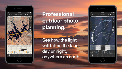
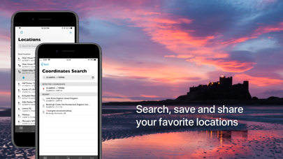
TPE's map-based approach means you aren't limited to a predefined list of locations, which often miss the places many photographers go. Instead, search for any place name on the planet or position the map pin exactly where you want it.
Advanced features including visual sun and moon search, automatic time zone and elevation detection, correction for atmospheric refraction and height above the horizon, ensuring that you have the best possible information for planning your shoot.
You can even determine when the sun or moon will be visible behind nearby hills and mountains.
Key features:
- Time and direction of sunrise, sunset, moonrise and moonset
- Phase of the moon and % illumination
- Times of civil, nautical and astronomical twilight
- Graphical display on a wide selection of map types
- Two topographical/terrain map types
- Two offline map options
- Movable map pins: drag and drop the pin exactly where you need it
- Track curent heading using compass (on compatible devices)
- Shadow lengths displayed to scale on map
- Save any location you want: no fixed lists
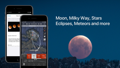
- Celestial events including moon phases, apogee, perigee, solstice, equinox, meteor showers, lunar and solar eclipses
- Does not require network connection for rise/set time, azimuths and sun/moon position
Advanced features:
- Automatic time zone detection for any location on earth
- Determines elevation above sea level
- View azimuth and altitude of sun/moon for any time of day/night
- Distance, bearing and elevation angle between any two points
- Location import from KML or KMZ
- Location export via email as KML
- Display azimuths/bearings relative to magnetic north
- Configurable timeline display
- Sun/moon transit times
- 'Golden hour' time/duration
Geek features:
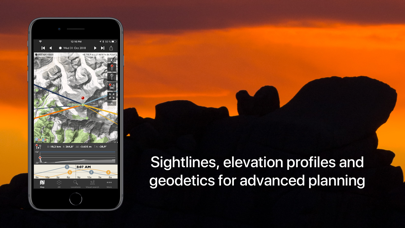
- Line of sight analysis
- Find when the sun/moon will appear from behind a hill or ridge
- Advanced visual sun and moon search: find when the full moon rises as the sun sets in a given direction
- Azimuth or altitude search priority
- New crescent moon visibility
- Compensation for atmospheric refraction
- Compensation for elevation above the horizon
- Distance to the visible horizon
Available map types include:
- Standard, Satellite/Hybrid, Terrain
- OpenCycleMap Topographic
- OpenStreetMap
Note:
- Maps and elevation-based calculations require a data connection, except for offline map tiles previously downloaded and stored on your device
- Topographic map data is available only between 60°N and 47°S
- Offline maps are not always available for the highest zoom levels
- Topographic maps courtesy of OpenCycleMap.org
- OSM map tiles courtesy of MapQuest.com
- Availability of map types is subject to change, due to 3rd party map service availability, terms or conditions
- Future updates to TPE will require iOS 8
TPE for Desktop has been a favorite of photographers around the world for over five years. Now you can carry it with you.
Reviews
App is ok could be much better easily
Jackie Martling
Why doesn’t the app automatically reset to today’s date? It asks you if you want to, but also includes a “don’t ask again” button. Which is ambiguous. Is it don’t ask again because it will always reset or don’t ask again and it won’t reset. I assure you more often than not people are interest in today and future dates. Not historical.
As important as remembering a memory card
Steve Uffman
Great app and I have Sky plus option. Great for sunrises and sunsets
Insanely good
GesichtswurstHD
Once you get the hang of all the controls and information shown, this app is insanely useful. Love it!
Best app for Photographers bar none!
PorkNBeans73
If you photograph at all this is thee most needed utility next to a tripod. No, that’s not an exaggeration at all! Take the time to watch the tutorial videos and you’ll understand immediately when you plan your shot within the app. If I had to spend a couple of hundred to buy this app (lifetime fee of course) I wouldn’t find an issue doing so. Defined in three words to anyone thinking about it. YOU NEED THIS!
Works great for wedding planning
Joebackward1
I’ve used this for years, both as an amateur photog and in my work as a minister who does weddings. Photographers’ Ephemeris is great for helping a couple imagine the day when I first meet them a few months before. It visualizes, wonderfully, where the light will be in the church and on the steps at the hour appointed for their celebration. Usually, showing it too them makes them grasp that their plans are for real. It helps them get serious. It presents reality Thanks Crookneck people.
Best app for Photographers bar none!
PorkNBeans73
If you photograph at all this is thee most needed utility next to a tripod. No, that’s not an exaggeration at all! Take the time to watch the tutorial videos and you’ll understand immediately when you plan your shot within the app. If I had to spend a couple of hundred to buy this app (lifetime fee of course) I wouldn’t find an issue doing so. Defined in three words to anyone thinking about it. YOU NEED THIS!
Avoid Skyfire if you live near the border or coast
CFlo SD
This review is specifically for the skyfire portion of TPE. While TPE is great, Skyfire is the complete opposite. There have been updates to the forecast map which heavily reduce its usability for anyone who lives near coastal border cities like San Diego, Los Angeles, or Seattle. 1. The map has been cropped to 50 miles off the US coastline. Clouds are still visible 300 miles off the coast, making this useless for ocean shots 2. The forecast crops out all of Mexico and Canada, including their international waters. This means that your app is useless at least 50 percent of the year, especially during winter.