Photographer's Ephemeris 3D
| Category | Price | Seller | Device |
|---|---|---|---|
| Photo & Video | $11.99 | Crookneck Consulting LLC | iPhone, iPad, iPod |
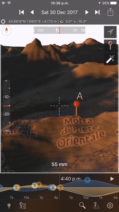
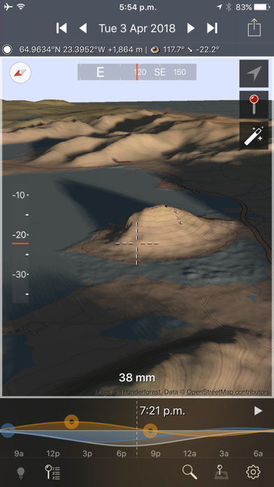
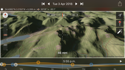
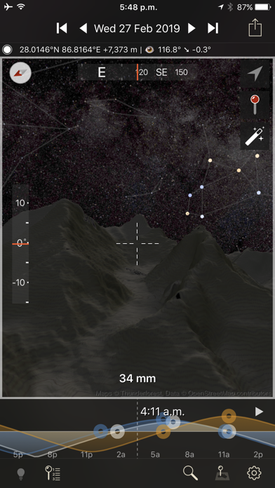
The Photographer's Ephemeris 3D (TPE 3D) is a unique natural light visualization tool for outdoor and landscape photographers shooting in varied terrain. It's a 3D map-centric Sun, Moon and Milky Way calculator: see how the light will fall on the land, day or night, for any location on earth.
"TPE3D predicted the light in the distance in the gap just before the right most hill very accurately." - OnLandscape Magazine
"This app has become an indispensable tool in my planning kit, I highly recommend it!" - David Kingham, Exploring Exposure
Watch a sunrise from the future in a rich simulation of sunlight, moonlight and starlight set against the actual topography of your planned shooting location.
Need to see when the arch of the Milky Way will rise between two mountain peaks? Need to see what time in the afternoon the valley will lose direct light in September?
Watch the light unfold under clear skies hours, days, weeks or years before you're actually there in person.
Key features includes:
- 3D topographic maps with simple navigation options
- Sun, moon and galactic centre continuous timeline showing key rise, set and transit events
- Full search capability to find your location (or enter decimal or DMS coordinates directly)
- Automated playback to watch a realtime or faster-than-realtime simulation of the light
- Flying mode for quick movement around a scene
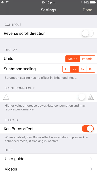
- Enhanced mode for maximum topography and shadow detail
- Symbolic represetation of the Milky Way in Flying mode
- High resolution Milky Way and stars in Enhanced mode
- Direct elevation control for the 3D model camera
- Camera pitch and bearing indicators
- Moon phases are rendered accurately in the 3D scene
- Zoom in/out to equivalent 35mm focal length in enhanced mode
- Daily and annual events lists
- Shared location database with TPE
- Navigation and Artificial Highlights lighting modes
- Support for multiple map pins
- User settings for controlling scene complexity
If you like to plan your natural light photography to capture the photo opportunities others miss, TPE 3D is a must-have tool!
Note:
- This app is CPU and graphics intensive: modern device models provide the best user experience and highest resolution data
- Not recommended for users who only shoot in flat terrain
- Satellite maps are not included
- Building are not shown in 3D
- Max elevation data resolution is 1 arcsecond (approximately 30m/33yards)
- Requires an internet connection
- Does not currently provide simulation of lighting during solar and lunar eclipses
- Topographic data is available only between 83°N and 83°S: data may contain artifacts and errors
- Availability of map types is subject to change, due to 3rd party map service availability, terms or conditions
Reviews
Needs better maps.
Canid
On an iPad Pro 9.7, the map detail, even in enhanced mode, is too poor to use for any precision location planning.
Not as useful as I had hoped.
AZBeaubaton
I was hoping this app would help me predict light and shadows on a given day and at a given time. To some extent, it does. But not the level of details that I need. A bit disappointed.
Mushy light, doesn’t work as advertised
Disappointed84621
My results look nothing like the images in the App Store. Moving from sunrise to noon in the location I selected, an oceanfront bluff, you get a slight sense of shadow on the sand and then the light overall just comes up. In real light, there is absolute shadow on the sand until the sun gets up high enough to light it. Can I get a refund? Thank you
“ locating”………
dento96
This app used to be 5 stars. Now I can’t get it to work. So frustrating. The 3D map loads and then nothing just says locating with the spinning icon and NEVER LOADS. I have a brand new iPad Pro with latest updates and still won’t work. Grrrrrrrrrrr
Cool idea, bad design
sealere
None of the locations I've used (one which is a national park) have any useful mapping. Slow and Terribly unresponsive interface
Great addition to the family
Dsmgeoman_OK
The 3D sibling is a welcome addition to the family. I have used TPE and it's sibling Photographer's Transit for years to plan photographic opportunities. Still some bugs to work out, but this is/will be a great tool.
Really cool!
Colin Robertson
The UI is a little confusing, but this is the photography planning tool I've always wanted; to be able to pre-visualize my shot at any geographic location at any time of day.
Not easy to use
DublinJade
I like the TPE 2d version, I have been using it for a few years, so I purchased TPE 3D, I am still struggling with this app, it’s so difficult to use, I wish I can return it.
Great paired with Ephemeris and Transit
dkrowan1
I just got back from the Smoky Mountains and used 3D to fully visualize and plan shots down to the lens used and where to set up. Very accurate and just plain fun to use and even did some "arm chair" travel and photo set ups in the hotel at night to pass the time - great app and I love the integration with Ephemeris for smooth work flow. Well done!
Ok, but needs a LOT of work
GP|13
I’ve used this app for planning and teaching night photography since it came out. It helps visualize the scene in terms of alignment of stars and large landscape features, but there are major drawbacks which make this app frustrating to use: 1. No satellite imagery. Regardless of the ‘complexity settings,’ there is no access satellite imagery. This is not only a disappointment, but unrealistic for a navigational/planning app. You can access satellite imagery with TPE, but not TPE-3D. This is a dealbreaker. 2. Navigating is impossible. The app is limited to a ‘zoom-out level’ that does not allow you to scroll to areas far apart. For example, in the original TPE, you can zoom out as far as you want to scroll to different states if need be for quick and easy browsing. This app won’t allow that. The only saving grace, which is by no means a real solution, is to go back to the regular TPE, pin the location, then export to TPE-3D. 3. Your ‘current location’ is not clear. Select ‘my location’ and the app flys to a general vicinity, but there is nothing to represent where you are located. When you pair this with the illegible background map, it’s impossible to know where you are located. 4. Moonlight across the landscape is too dark to notice a difference. Sunrise or sunset light within the app is legible, but I would like to see moonlight represented much brighter. If you’re planning a shot with moonlight and you look at this app outside during the day, it’s impossible to see the change in moonlight across the landscape. With these current design issues, most of my clients try the app once, then never open it again. This app has a lot of potential, but I still prefer using Google Earth’s landscape desktop feature.