SkyCharts XC EFB
| Category | Price | Seller | Device |
|---|---|---|---|
| Navigation | Free | SkyCharts LLC | iPhone, iPad, iPod |
Includes a free 30 day trial.
If you wish to continue using SkyCharts after the trial, please purchase a $3.99/month auto-renewing subscription.
See full description regarding auto-renewing subscriptions, privacy policy and EULA below.
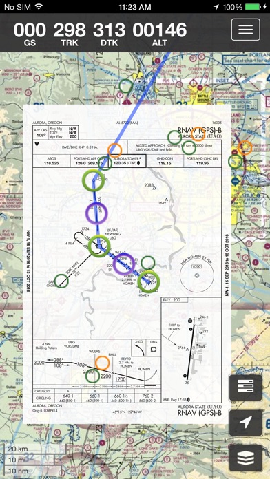
Now also includes geo-referenced approach plates in USA/Alaska!
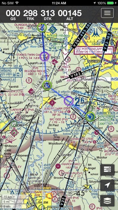
The application has world ONC/VFR charts as base-maps.
For USA/Alaska, the application has all current FAA VFR (sectional+WAC), IFR (High and Low), TAC, FLY (flip side of TAC chart), Helicopter, Gulf Coast WAC, Gulf Of Mexico, and Wall aviation charts.
Grand Canyon charts are included in the TAC charts, and Bahamas and Mexico as WAC charts.
Also included is a METAR/TAF overlay, and an IFR overlay to view routes on top of VFR charts.
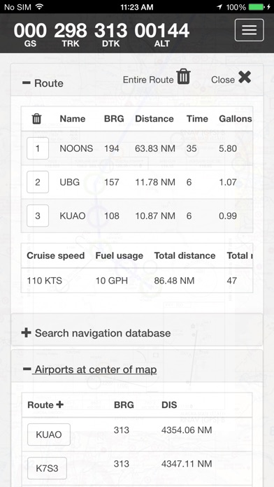
Its very easy to create and modify routes directly on the map or by drag&drop in table.
Navigation readout is configurable to fit exactly what you want to see. It also has a nifty auto-layout feature that selects fields for you in both portrait and landscape mode.
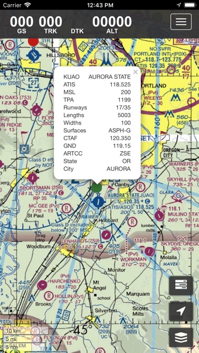
DOUBLE TAP on map to view A/FD and approach plates.
Map has VFR/IFR/LIFR color-coded weather METARs, with orange TAFs.
SUA (Special Use Airspace) information is also available.
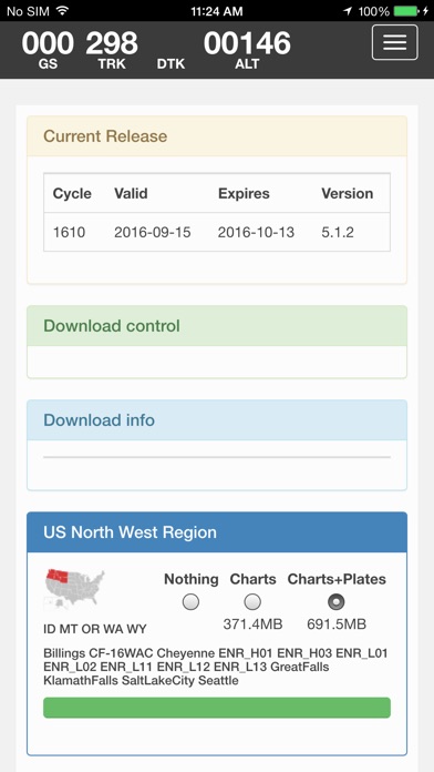
Download charts and plates for offline usage.
Features:
* Fast zoom/scroll of included charts using standard gestures.
* Allows download of charts for offline usage. Charts are selected on a region basis.
* Navigation computes GS, TRK, DTK, DIS & ETE to final waypoint.
* METAR/TAF color coded dots according to ADDS: http://www.skycharts.net/?page_id=421
* Double tap on airport to select A/FD and TPPs/IAPs to view.
* Huge built-in navigation database, with all 20,000 airports, 45,000 FAA IFR/VFR navigation fixes and 2,100 FAA VOR/ADF fixes.
For more information, please see the webpage at
http://www.skycharts.net
The monthly subscription of SkyCharts XC aviation data of $3.99 is auto-renewed. Payment will be charged to your iTunes/App Store account at confirmation of purchase. You can turn off auto-renew at any time from your iTunes/App Store account settings, but you must do so at least 24 hours before the end of the current subscription period to avoid being billed for the next cycle. No cancellation of the current subscription is allowed during the active period. Any unused portion of a free trial period will be forfeited when you purchase a subscription to SkyCharts XC.
The privacy policy and EULA can be found here:
http://www.skycharts.net/?page_id=1465
For fast response to all questions, comments or suggestions, please email [email protected]
Reviews
Original Skycharts Pro Purchasers Getting Ripped Off
avguserguy
Skycharts Pro owners were promised regular updates free of charge, now it’s a paid subscription. Do not support this shady business, their business practices have shafted those that supported them in their infancy.
Frequent crashes
Rmm34
App crashes about every 5 minutes on iPhone 7 10.1.1. Thank you so much for what was a fantastic app for years (pro). New app essentially useless in flight due to unreliability. Even the download process does not work properly; if one pack fails, no button to retry download. Too bad you stopped supporting the good app. It is time to move on to something else.
Greatly improved!
Gabe12243
The new update resolved a lot of the bugs and issues of the previous version. I use this as a drone pilot and it is very helpful. I am able to update charts and subscribe successfully in the new version.
Downloading charts is impossible
Zaney Laney
Good luck trying to download charts. My phone to s burning up and and my battery is dying while download progress is not getting anywhere. Been trying for hours. I would NOT recommend this app.
Will not work !
Prior fish owner
SkyCharts Pro worked with no problems but this XC version has many faults on my iPhone 6S . 1. After downloading XC I picked the north east download with plates , after a long time it finished loading and every time it starts it goes to the west coast and the only way to get to the east coast is to drag across the entire US to the north east . Now every time you go into the data to change layers Ect it goes back to the west coast and it starts again and no matter what you have selected in the prior move it always ends up on the VFR map and you have to try and start again with no chance of changing it . There is no way I can find to set the starting airport in Massachusetts like I want ! It has failed to work with my Elite Simulator software period ! Now I have deleted the app 3 times and again down loaded the North East with the same results. I would like to subscribe but will not if it doesn't work with my Elite or iPhone 6S software
How did it get worse?
Cndnbcn
This is the updated version from the old SkyCharts pro. It's clunkier, slower, doesn't interface with sims, why is my current location always used to start route planning? It's just obnoxious. They ruined a good, simple thing. This new version adds nothing on the old one, just a bad interface. The sim thing was nice to have, but not a big deal, but for it to not even load charts sometimes when I open it up, that's an issue. It basically has one job!
Previous version was much better
Egor*+=
The most important thing about a chart is to actually be able to read it. The previous version of this app had excellent chart clarity. But not the XC version. It's all blurry when you zoom in to read things like frequencies and obstacle elevations. Total waste of time.
BBQ Pilot
MeatSmoker
What's up with the banner ads on the paid version recently? No good. Takes forever to load now.
Fantastic!
iLoveGizmos
Love the geo-referenced plates directly on the map! Flight sim support makes it easy to practice approaches! And support is great, got an answer right away!
I wish I could rate higher
Nickn@me created
I've done my best to support this developer. I'm a flight instructor who has suggested this app to my students for years. I'm not sure why he decided to completely change the app, but it is absolutely for the worst. It is about as un-user friendly as you could possibly get. I have flown with the old app all over the country and way down to the south tip of the Bahamas. It used to be that if I needed an approach plate or airport diagram, I could bring up the airport and click on what I needed. It downloaded it right there in seconds. Unfortunately, the old version no longer exists. I paid $4-$5 for this new app, so my wife and I could take a trip. Nothing on it worked. We couldn't bring up a plate without downloading several states. After several attempts and an hour per attempt, they never did finish downloading. We had to make the trip without a working app. Several dollars well spent. Also, the auto renew on the subscription made me mad. I'm all for the guy making money, but this is ridiculous. I had to google the way to turn off the auto-renew, and it wasn't easy. Of course, Apple makes it as complicated as possible.