GPS Stone (GPX Trip Recorder)
| Category | Price | Seller | Device |
|---|---|---|---|
| Navigation | $1.99 | Francois Lamboley | iPhone, iPad, iPod |
GPS Stone records and exports all your trips to your main computer for geo-tagging/photo-tagging or trip management.
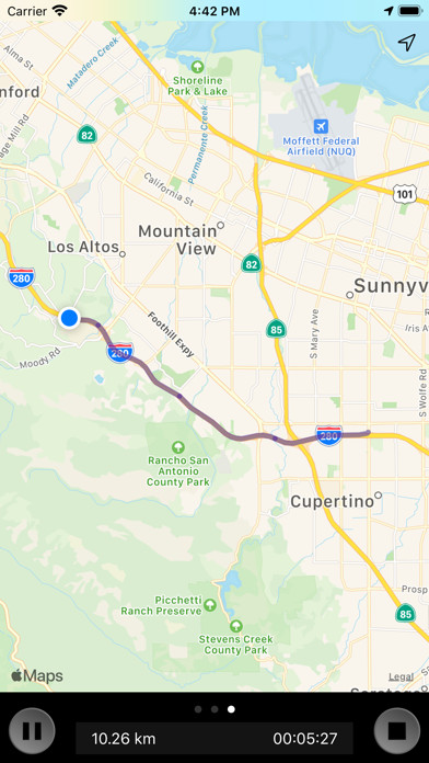
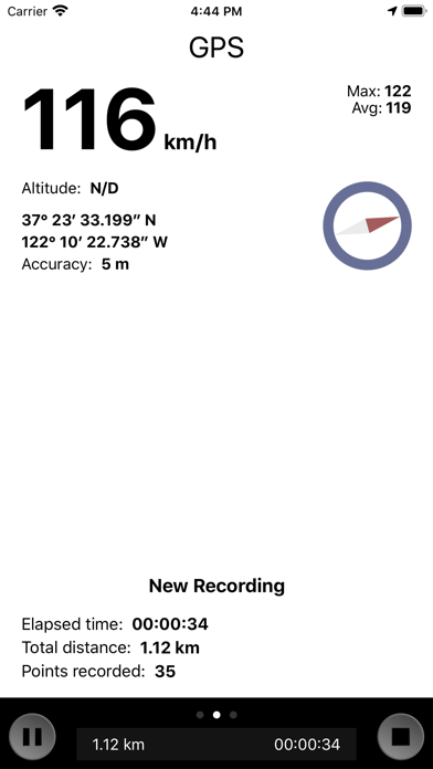
Follow your trip on the map in real time, or use the detailed view with the current speed, average speed, altitude, traveled distance, position accuracy, direction, and more!
Once back home, review where you have been at a given time, and for how long. It also works for sport activities, cycling, car, trekking… of course, it can be useful for any photo tour walk.
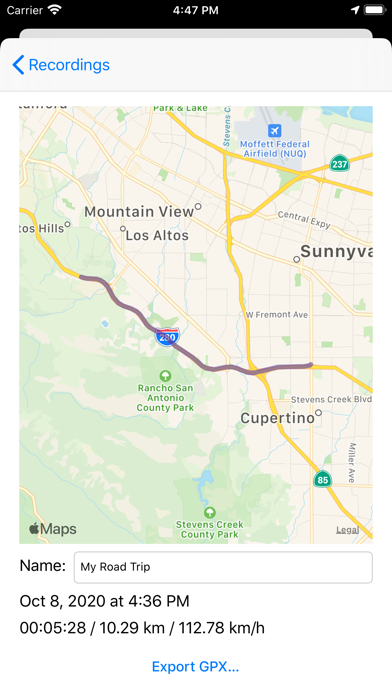
Additionally, GPS Stone can export the trip you've recorded in the standard GPX format. See your trip on Google Earth, or compatible software such as Atom GPS and GeoSetter for PC or HoudaGeo for Mac.
-----------------------------------------------
GPS Stone Trip Recorder can:
• Record and date your trip
• Show live path on the map
• Auto-restart recording after a phone call
• Check your instant, max, and average speed
• View the distance, altitude, GPS accuracy
• GPS coordonnates
• Compass to see your current direction
• Delete and rename any trip
• Units: mph or km/h
• Fine tuning of log details and file size
• Send GPX by mail
Keywords:
GPS,Recorder,GPS Recorder,Travel,GPS Data Logger,Map,Speed,Phototagging,Photo Tagging,Geotagging,Geo Tagging,Compass,Trip Management,Trip,GPS Tracker,ATOM GPS,GPX,Travel Recorder,Travel History,History,GPS Log,NMEA
This application use background mode, continued use of GPS can dramatically decrease battery life.
Reviews
Perfect for tagging pictures
Piranha72
This is exactly what I needed to tag my pictures from my DSLR. Tested it out in my pocket and it was dead on and ran in the background on my iPhone 4.
Great app, but...
Mr. Hayhurst
For the makers of the program, I really need a button to toggle from the map back to the speedometer. I can't hold my finger steady enough on the screen to slide back while riding my bike. Otherwise it's a great little app. Please consider on updated versions for a 5 star rating. Thanks.
Usefull
SinAnAbAssie
I do use this application whenever I navigate... Checking my speed ( not 2 exceed the limits ), in addition to how long distance I cut in my travel, I hope it will be developed ASAP,
Stupendous App!!!
CrazyGuy1120
It does exactly what it says. Someone who loves traveling will love this app as well. Its brilliantly designed…. Thanks a lot !!!
Great toy
Taiyin
I like this app a lot it is a great conditioning tool for equine riders fun to exact distance & speed and helped me navigate unknown trails
Crashes often
Plausible_Deniability
I like the idea of this app, to record a GPX file of a trip. That file could be useful for traffic accidents or citations. But it crashes after 5-10 miles. I'd rather it record an entire trip, say 500 miles in a day! I suspect it's a compatibility issue. My device is iPhone 4S ios 6.0.1. Please fix, otherwise I'll be forced to write my own GPX recorder and put it on iTunes!
Disappointed
MikeS_ATL
I bought this app before a hike hoping to use it to help track my way back once I had recorded the path. It crashed about two hours in. It did save the trip, but I learned that it won't show your current location on a saved trip.
Great for Geotagging photos, but...
Obliteral
The reason I give it three, and not five stars is because I have to edit the GPX files every time I want to import it with my photos. The time of the file name and the recorded points inside the files are off by seven hours. I can not figure out why this happens. Otherwise. The app does exactly what I want.
Problems geotagging
dglas
On second attempt at geotagging I set the app to record as I drove along an interstate highway. About midway I stopped in a small town adjacent to the highway where I took a few photos. The recorded track just continued straight along the highway and did not show any deviation and did not capture any of the photos for geotagging. Checking the times along the recorder route there is a 40 minute lapse and it was within that lapse that I exited to the small town and shot some photos. The photos themselves contain the time stamp when they were shot. I did not touch the iphone at any time during the recording. Any ideas??? In my first attempt at geotagging I paused the recording midway for a few minutes. The recorded map on the iphone did show the entire trip - before and after the pause. However when I emailed the file to my computer the only portion of the recording was after the pause - so lost any geotagging prior to the pause.