Pocket Earth Maps
| Category | Price | Seller | Device |
|---|---|---|---|
| Travel | Free | GeoMagik LLC | iPhone, iPad, iPod |
• Detailed worldwide maps and travel guides • Works completely offline even with GPS • Great when abroad, NO data roaming charges • Online routing with Voice Guidance and much more!
• We give you one offline city for free, in-app upgrade to access unlimited worldwide offline maps and topographic maps feature.
« Reviews »
“I love this technology” – Natali Morris, Tech Reporter, NBC’s Today Show
Editor's Pick Best Offline Map App – thedigitaltrekker.com
“The best travel app in the world… Don’t leave home without it!” – bonvoyageurs.com
“Very impressive app with unmatched features.” – toptenreviews.com
« Maps »
• Beautiful Retina quality maps at a fraction of the size! The fastest and most beautiful offline maps on the App Store!
• Detailed and interactive worldwide maps! More than 100,000 places & completely free!
• Access your maps online and offline! Saves on data roaming costs!
• Personalize the maps to show the info you want!
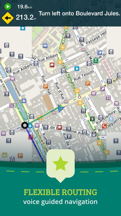
• Online Routing with directions. Save your multi-stop itineraries for offline voice guided navigation!
• Online street address search and contacts integration!
• Did we mention everything is offline? Works anywhere- cities, small towns, even in the middle of nowhere. Never any roaming charges. We dare you to try it!
« For the Traveler »
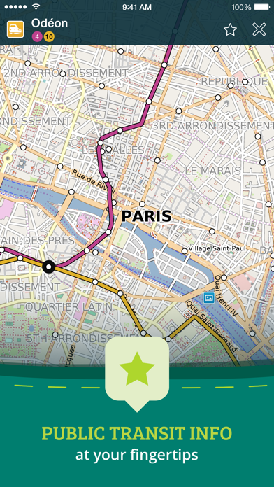
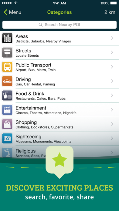
• Find out about thousands of interesting places - hotels, restaurants, bars, tourist sites, even get metro and public transit info!
• Our super wide area Nearby search is also super fast!
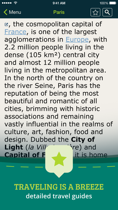
• Have all the travel info you need with more than 50,000 detailed Wikivoyage Travel Guides and more than 1 million Wikipedia articles in 7 languages!
• Customizable Pins and favorites groups! Add notes and mark and share favorite spots!
• Share maps links and your current location!
« For the Adventurer »
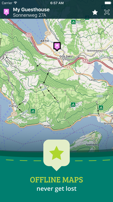
• An in-app purchase option offers topographic maps. Get high performance, high accuracy 10m / 50ft contour display world-wide. The ONLY offline app that lets you download large areas, even entire countries! Contours are displayed on our existing maps for all Activities.
• Hiking and Cycling maps! Great for geocaching and getting off the track!
• GPS track recording lets you see what route you took! Great for hikes, cycling and off road! Never get lost again!
• Import/Export support for GPX and CSV files! Share with friends using PE Archives.
• Displays and lets you search for map coordinates in all common formats (including DD, DDM, DMS, MGRS, UTM/UPS, GeoHash, and what3words)!
• Numerous GPS settings for your preferred configuration including compass and heading arrow or rotation, look ahead mode, accuracy and recording settings.
...and much more - so try it out!
« How's it Work? »
Just select the cities, regions, or even whole countries you want to download, and it will be available for offline use, complete with information on thousands of POIs (Points of Interest), and optionally, topographic maps, travel guides and Wikipedia articles.
To learn more about Pocket Earth or the community driven open data sources that we use, please visit our website.
Don’t forget this:
1. Continued use of GPS running in the background can dramatically decrease battery life. Only the GPS Route Navigation and GPS Track Recording features will use the GPS when running in background.
2. This app uses data from the amazing community driven open mapping project called openstreetmap.org! Coverage detail may vary by region, please visit our website to check the map detail for your regions of interest.
3. Does not currently support all asian texts on the map (Chinese, Japanese, etc).
Reviews
Bob
b17mechanic
This is a "demo" version,... only good for Dublin, Ireland. If you want anything else you have to buy the full version. Doesn't tell ya that in the ad or how much it is.
Very limited demo
Seatac33
Only shows Ireland, so I don't know if this will fulfill my needs or not. Am NOT willing to pay three dollars to find out it is not what I need after all. It does zoom in very closely to a chosen city in Ireland, though, but that is not what I am wanting. I wish to have a quality atlas that shows all the countries on each continent, and also zooms into each city.
Great maps
AKChas
The maps are very easy to use. A simple spreading apart of two fingers and more detailed maps quickly appear. I've searched through other apps and really enjoy using this one.
Can't really be used offline
Cal L. Kent
I thought this would be the solution for getting around while out of the country without paying foreign data rates. It's not. You can't do something as basic as get a route to a landmark without being online. I was left clumsily trying to drive while repeatedly looking down at my screen to see where on the map I am since I couldn't plan a route or get turn by turn directions without being online even though the full map had been downloaded to my phone. I don't see the point of this if it can't give you directions without being online.
Fantastic app
Baaapu
I am an airline pilot and use it for illustrations quite frequently, worldwide.
Won't route without internet connection
DSL diva
It won't work without internet connection or wifi.its not really an offline map
One of my favorite Apps
Drbobgold
Before leaving for a Danube River cruise, I downloaded all of the maps for the Eastern European countries, as well as several for the USA. They didn't take up much space, but were incredible, both while walking and driving. I was amazed to find out how much additional information was available everywhere with Wikipedia references that were quite extensive and that went far beyond what our local guides had given us, even in remote locations that I had never even previously heard of. While walking I was able to put in a street or address, and find my way to the location while offline. This worked well, but of course the one much to be desired improvement would be the ability to get turn by turn directions while offline, as the destination is drawn as a straight line from location to destination. However it is constantly upgraded as you move in the direction of your destination, so that it does take you there. We are a traveling family, and I have urged everyone to make the purchase. It is probably the best few bucks I have ever spent.