
Pix4Dcapture
| Category | Price | Seller | Device |
|---|---|---|---|
| Utilities | Free | Pix4D SA (Pix4D AG) (Pix4D Ltd) | iPhone, iPad, iPod |

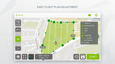

• Select an area for mapping.
• Start a fully autonomous mission.
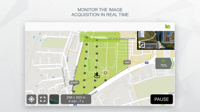
• Images are taken automatically and are geo-tagged.
• Interrupt mission at any time in case of danger.
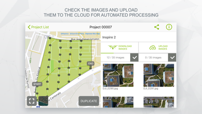
• Transfer images to your computer.
• Guide on how to convert images into maps and 3D models using Pix4Dmapper desktop software or on the cloud.
Currently, the app supports and was tested for DJI Phantom 4, DJI Phantom 3 Standard, DJI Phantom 3 Advanced, DJI Phantom 3 Professional, DJI Inspire1, DJI Matrice 100 and Parrot Bebop2. Make sure you have the latest firmware installed.
The app is not an autopilot and does not avoid obstacles. Watch this video for more information on using Pix4Dcapture: http://youtu.be/YKOeGjfCFUw
Pix4D accepts no liability for damage, injuries or legalities from the misuse of this app. Use only in safe environments.
To convert images captured with the app to maps and 3D models, download the desktop software Pix4Dmapper: pix4d.com/download.
Video : http://youtu.be/w8L4pT81xCY
Reviews
Just a basic flight app
sMyNickname
Doesn’t sync with airdata.com No terrain awareness Doesn’t save mission plans to cloud or iCloud No motion blur setting to slow speed Just a very basic app.... It’s responsive and laid out nicely.....can’t use it though because it lacks the above.
Kills the battery
EG1451
Within minutes of starting this app my phone gets hot and the battery drains extremely quickly
Confusing n heart breaking
Fzanou233
I simply can’t understand how the mavic air is compatible or supported for mapping whilst the advance mavic air 2 and air 2S is not supported. Plz u guys need to make some serious changes if not we all going to join Dronelink.
It needs some work
everyisfrustrated
It regularly misses images, and regularly refuses to send the mission to the drone. The only solution to the second issue I can find is uninstall, reinstall, and remake the area….while on the job site. There should also really be an online mapping tool so I can layout missions ahead of time and save them.
Awful program
R6Rider
Unfortunately I am forced to work with pix4D for work however there are lots of programs out there that do a much better job than pix4D and cost at least half as much, two examples are Agisoft meta shape and drone deploy.
Add the new Enterprise Advanced
IMT 501
Our company would really appreciate if you would add the new DJI enterprise advanced it would really help out a lot of our mapping
Geofencing error
Boobooo ok ooo ok
There seems to be a geofencing error within the app, I am not in a geozone and I cannot start my mission with this error.. help with the fix please?
Could be better
sidc3000
I really wish Pix4D would concentrate on this app updated. I’ve been running into issues with the app sending my drone back with 70% battery left. Then when I resume the mission it starts the whole thing over again. This is the only mapping specific app. They could do so much better
Inconsistency is unacceptable
Biobozeman
Sometimes it works. Other times it leaves out critical photo files. I used it to auto fly grid mapping missions. Sometimes it does not send signal to the drone to take a photo. Therefore, the map is missing several photos/ data points. Therefore, the map is useless to me and my customers. I’m going to use other software from now on.