Navionics® Boating
| Category | Price | Seller | Device |
|---|---|---|---|
| Navigation | Free | Garmin Italy Technologies S.R.L. | iPhone, iPad, iPod |
Navionics+ includes:
√ Download of the following chart layers that will permanently reside on your device:
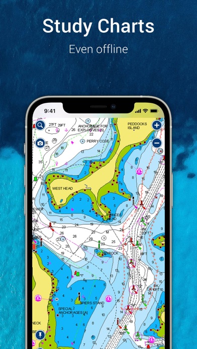
-NAUTICAL CHART for all essential cartographic reference detail. The most accurate and thorough set of information based on Hydrographic Office data, Notices to Mariners, new publications, our own surveys, and reports from users. It provides port plans, safety depth contours, marine services info, tides & currents, navigation aids and more.
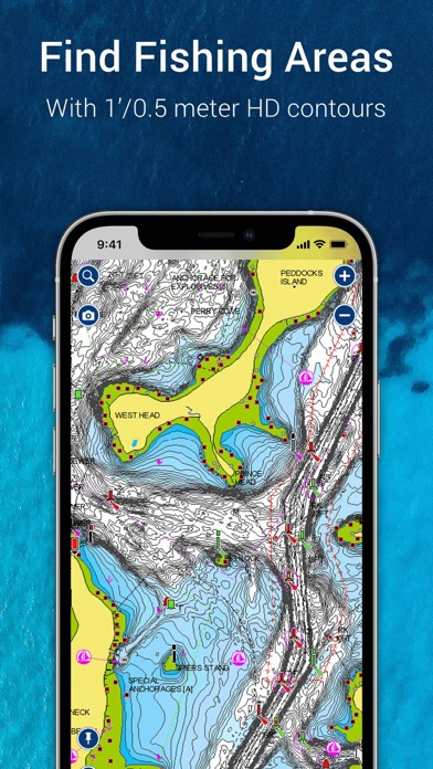
-SONARCHART™ HD bathymetry maps with up to 1 foot contours featuring extraordinary bottom contour detail, great for increasing awareness of shallow waters and locating fishing areas at any depth level. Be part of the community and contribute by uploading your sonar logs to enhance it.
- COMMUNITY EDITS made by users (rocks, wrecks, etc.) and shared for all to benefit.
√ CHART UPDATES: we deliver more than 2,000 updates every day! Take advantage of our updates as frequently as you like.
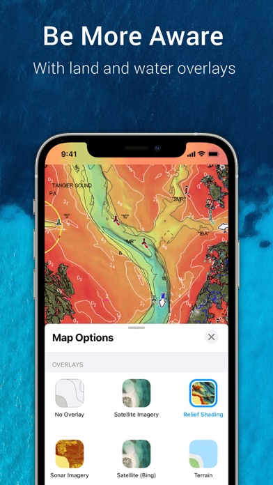
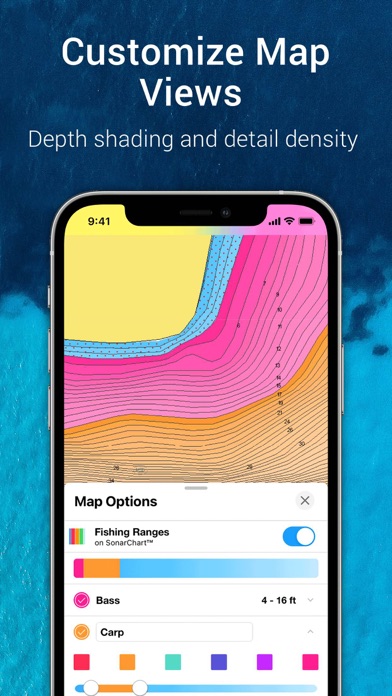
√ ADVANCED MAP OPTIONS to highlight Shallow Areas, select Depth Shading, filter Depth Contours, and adjust shorelines to selected Water Level. Includes a Fishing Mode.
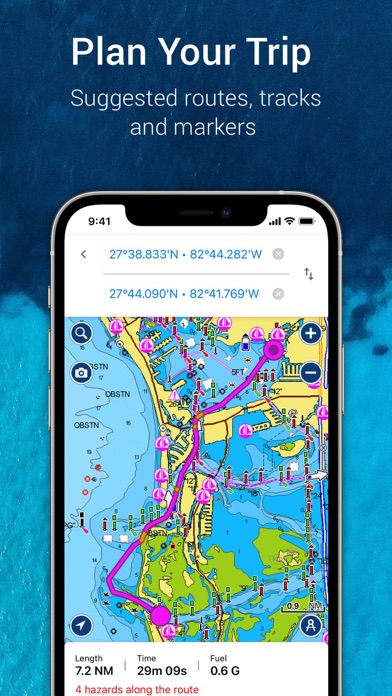
√ NAVIGATION MODULE for advanced route planning with ETA, distance to arrival, heading to WP, fuel consumption and more!
√ DOCK-TO-DOCK AUTOROUTING quickly creates detailed routes even through narrow waterways and channels, based on chart data and navigation aids. POIs are automatically shown nearby your destination.
Note: Download detailed maps by zooming in or from Menu>Download Map. Check navionics.com for coverage.
Navionics+ is a one year subscription. At expiration you can renew with a discount of up to 50%. If you don’t renew, you can still use the charts you previously downloaded, along with several free features:
TRACK your journey, view speed, distance, time and COG. Save to archive, see stats and playback.
ROUTES: create and edit, based on speed and fuel consumption.
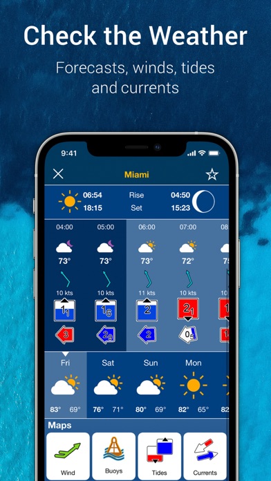
Measure DISTANCE, add MARKERS, get WIND FORECASTS and sun/moon cycles.
MAP OPTIONS: Satellite/Terrain, Safety Depth and Easy View (not on Govt. Charts).
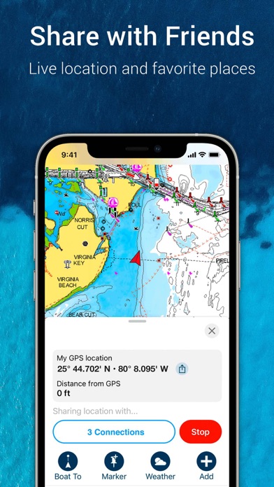
SYNC Tracks, Routes & Markers among your mobile devices.
MAGAZINES & GUIDES for location-based articles.
GOVT. CHART in US.
SONARCHART™ LIVE - connect wirelessly to a sounder to create your HD bathymetry map in real time. Select devices also allow for a fishfinder in split-screen. Logs are uploaded automatically to enhance SonarChart™.
PLOTTER SYNC - Raymarine Wi-Fi enabled plotter owners can transfer routes and markers, upload sonar logs for improved SonarChart™ and update their eligible plotter card connecting to Navionics through this mobile app.
Updates are available with iOS 7.0 or higher devices. GPS running in the background can dramatically decrease battery life
To enjoy our charts in HD, search our apps for iPad.
Reviews
What happened?
bewilderedinNY
The app is now basically useless other then checking contours of the body of water your fishing. Your location doesn’t update so when you are relying on this app to get you out to the spot you marked you’re out of luck unless it magically starts working. Even then the spot is off compared to your true location.
Boating
milo keylargo
Using the app is often problematic it can navigate incorrectly among other things. Strong WiFi is a must which isn’t possible out at sea even accessing satellite signal
Garbage
Disapointed Angler
I used to love this app but deleted a couple years ago when I had to take a break from fishing. It seems that the app I loved is long gone. Can’t even get into the login screen (something I didn’t formerly have to deal with) and keep seeing the endless circle icon.
Awesome app
MyNameIsDannyXRA
I really don’t understand the bad reviews. I’ve been using this app for over 6 years, fishing the open ocean up to 80 miles offshore. It has never let me down. Suggestion/request for the developers: please display lat/long as you move the crosshairs on the chart. Overall a great app, please keep up the great work !!!
What Happened?
joegeiger
I have used this app for several years and it has been stable and easy to use. This new version has added all kinds of automatic features that make the experience repetitive and just plain bad. Why does the map zoom out when I select an item? I have to zoom back in to see the detail again. What happened to the route creation where you would add points as you go and see your fuel consumption? Now it automatically adds a final point and you have to move it out of the way when creating waypoints and there is no fuel usage information. I paid for 2 subscriptions and after the third crash neither are loading so all I get is a blank chart and pop-ups asking for more money. This app doesn’t even deserve 1 star. I feel robbed!
After 16.2 All Detail Gone
Fjiwogsotsogso
Since the 16.2 update the app graphics have lost all detail, contours, etc. Local landmarks now just cartoony facsimiles. Tide charts for Buzzards Bay (Pocasset, Monument Beach, N Falmouth etc.) no longer show. What happened? App is pretty useless at the moment. iOS
Pretty Amazing
iPad Paul
I’ve been sailing on-and-off since about 1965 and I’ve using this app on my iPad for only a few years but I now can’t really imagine sailing without it. It can be quirky to learn initially, but it is astounding what it can do and worth the time spent at home learning how to use it. I believe the company and its new customers would benefit from a mini video course using a series of short videos to train people how to best use the app. I’m sure there are many things I’ve yet to learn. Here’s a tip: When you’re at home playing with the app, learning it, turn off location services on your iPad settings for this app so it doesn’t keep wanting to bring you home (instead of out on the water where you’re pretending to be). (Note to Navionics: a training mode would be useful to accomplish this.) Don’t forget to turn location services back on when you head out on on the water.
New customer
cameron sharif
Just subscribe to US and Canada options all the options are available to tap on but only basic map is working and nth else work.. I had high hope for this app and turn out it was just a waste.... New update... I try all the things I was told and it’s still doesn’t work 05/06/2021 6:32 Pm EST
Charts not updated
6twfam
I bought this app to use at Lake Powell but the water level is not up to date so it show the wrong levels. Wrong hazard warnings and even still shows the castle cut open when it is 15ft out of the water now! Don’t buy this!