Memory-Map
| Category | Price | Seller | Device |
|---|---|---|---|
| Navigation | Free | Memory-Map, Inc. | iPhone, iPad, iPod |
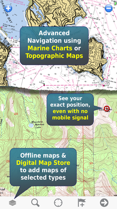
The app can be used standalone, but the maps and overlay data may also be used on your home computer for planning, and for printing maps on paper. Then upload everything to your phone or tablet and enjoy navigating outdoors with high quality maps.
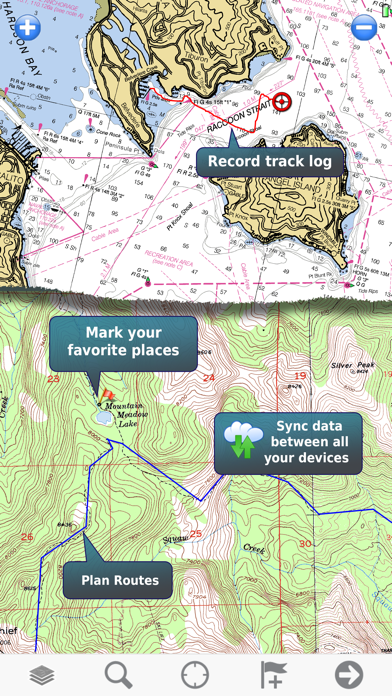
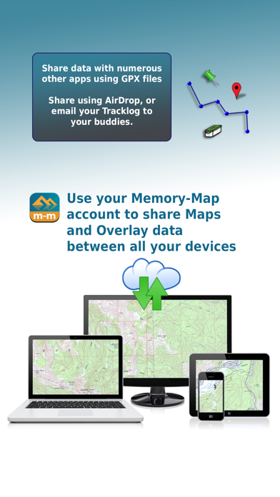
When you get home you can transfer your tracklog and points of interest back onto your computer, to see where you actually went, analyze your speed and elevation profile, and so on.
Features:
+ Fast scrolling and zooming
+ Import and export GPX files
+ Auto-rotate screen
+ Screen lock to prevent accidental screen touches while recording a track
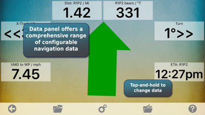
+ Shows speed and direction of travel, even while walking slowly
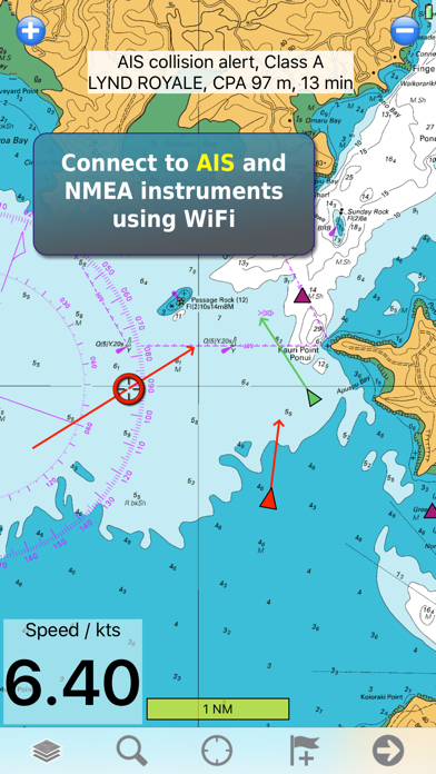
+ Support for GPS and Compass sensors, where available.
+ Placename index, works offline
+ Moving map, lock GPS position and automatically scroll the map
+ Records tracklogs with app running in the background
+ Create and edit marks, which may be linked to a web URL
+ Plan routes, measure distance and bearings.
+ Shows Altitude
+ Lat/Long, UTM and British National Grid coordinate systems
+ Email position marks or tracklogs as GPX files
+ Load maps from Memory-Map PC navigation software
Battery Use Disclaimer: "Continued use of GPS running in the background can dramatically decrease battery life."
Reviews
Not good!
Towdude
The maps are REALLY outdated. C'mon guys, I 220 was built in Shreveport what, ten years ago? If tour looking for current maps, don't look here!
Steve F
cant find an unused nn
I bought this app for a trip to Coste Rica. I am unable to find any maps.They refer to other sites.The default map is unusable at my home location,much too large scale. Extremely confusing to say the very least and a waste of my money.
Ok to buy new, but don't upgrade
not hydrox
I have owned Memory-Map apps for several years. I reviewed Memory-Map last year and rated it as 5-stars. On a trip to Patagonia last month, it performed flawlessly, It is still my best off-road navigation app, even though Apple bureaucracy has un-necessarily rendered its best features (including on-line purchases) inoperative with this "upgrade". Go ahead and buy it if you haven't yet purchased it. You will likely not miss what Apple has disabled. If you already own it, I recommend you not upgrade until Apple sorts out some of its issues with this app.
ver 1.5.0 works well
LCW Moviemaker
I have used Memory-Map for marine navigation for about 10 years, first on my laptop, then on a PDA, and now on my iPhone 3GS using version 1.5.0 of this app. Yes, there are a few things I'd like to see changed, but it works better and is MUCH cheaper than any of the 3 other Nav systems I used before this. You can get USA marine charts for free from NOAA's download site. These raster scanned charts are updated as needed by NOAA. For charts of waters outside the US, you may have to buy them from commercial sources. (For my sailing in the Caribbean, I still use old raster charts I got 10 years ago. They still serve well because those islands don't move around much from year to year!) It is great to have a moving chart plotter on board (my iPhone) that I can hold in my hand! I recommend this app (ver 1.5.0) to sailors old and new.
Navigator
PeterB26
You can't set up routes or navigate to waypoints with the latest version. The access to useful charts is limited. Obviously in earlier versions this was not the case. But this version is useless. Don't waste your time, money, or memory on this de-tuned toy.
Do not purchase
nthsand
$6.99 is only beginning then minimum $24.00 a 99.00 for more maps. Poor speed and response.
Waste of money
JSofMA
Do not buy, after purchased then you have to purchase navigational charts beginning at $19.99, there are other APPS out there way better than this one.
Good app, just needs a few more features
Tgsocal
I use this app quite a bit for boating & hiking, found it to be the best for noaa & USGS topo maps when out of 3G area. You can pre-download entire areas of maps fairly easily which is necessary when in the back country or on the ocean. When you use the mobile version in conjunction with their PC software it's very nice keeping track of waypoints, routes and tracks. Import/export works well. Marine NOAA maps are free to download, but you have to pay to get many other maps (USGS topo, Delorme, etc). But for ~$20 or so per map region I don't think it's that unreasonable though. I've compared many other topo apps, all of which seem to be lacking one feature or another. Memory map is worth the $$, but also lacks needed features. I end up having to use use it in conjunction with other apps, which is do-able but inconvenient. Would be much better if they could add a couple additional features, namely: 1) need ability to take photos within the app & tag them to waypoints/tracks... 2) Add 3D view (which is available in the PC version), or at minimum an option to view shaded relief via elevation data. Viewing topos in 3D/shaded relief really helps a ton, and seems it'd be fairly easy to add since they already have all the elevation data. Overall good app, just needs more features
Needs more work
Real Candy Apple
It's so painfully slooow to zoom/pan. The map is bitmap doc so when magnifies to usable scale, all the lines, words become stair-steps and square pixels… unusable.
like the Delorme map!!
Chewytoad
Found trails that I didn't even know where there. Navigation features work really well and I was able to design several routes right off the bat. excellent