
iMapIt Pro
| Category | Price | Seller | Device |
|---|---|---|---|
| Productivity | $4.99 | Marcus B B E Silva | iPhone, iPad |

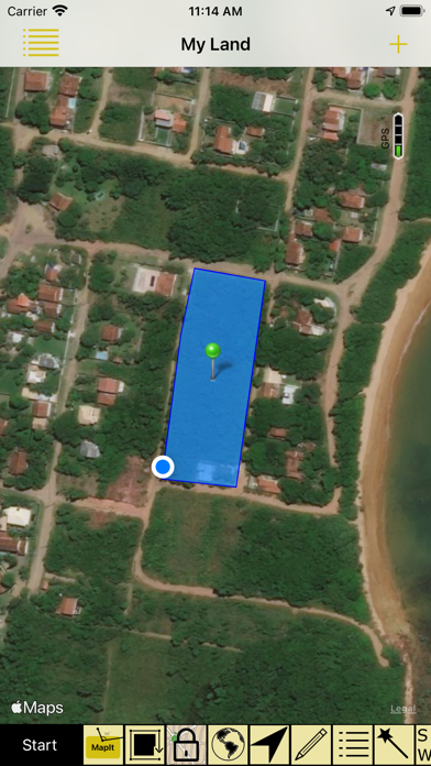


As you walk, collecting geographic coordinates with your iPhone, the surveyed location is being viewed on a map in real time.
Each place you map can be commented for future reference.
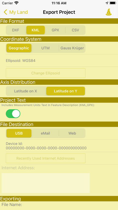
The places that you map can be exported to the DXF format for importing in almost any CAD software, or to the KML format for viewing on other map showing applications, or GPX, the standard GPS exchange format, for the interchange of GPS data applications and web servers on the internet, or still in CSV format for you to open in any spreadsheet utility. Those file formats can be exported using geographical coordinates, UTM projection (Universal Transverse Mercator) or the Gauss Krüger projection.
Those exported files you take from your iPhone / iPad through iTunes or sending them via email to you, your friends or clients. In this new version you are also able to upload the exported files to a web site that is previously prepared to receive them. For reference on how this new uploading feature works, please refer to our support site - http://imapitsupport.blogspot.com.br .
You can collect geographic coordinates to:
* Points - Register specific places with a point, as the place you most like to go, or the starting point of a race, or even the point where you spotted a rare bird;
* Line or Path - A sequence of points forming a line to register a track where you hiked, or the way you ran a race, or the path to arrive at your new home, or the location of a new fence you want to build. All mapped lines are calculated for you in metric and imperial units.
* Areas or polygons - A sequence of points forming a closed region, to survey a terrain you are interested in buying, or show the map of your land, or survey the contour of your new home, or delimit the place where you want to build a swimming pool. All mapped areas are calculated for you in metric, imperial and Thai units.
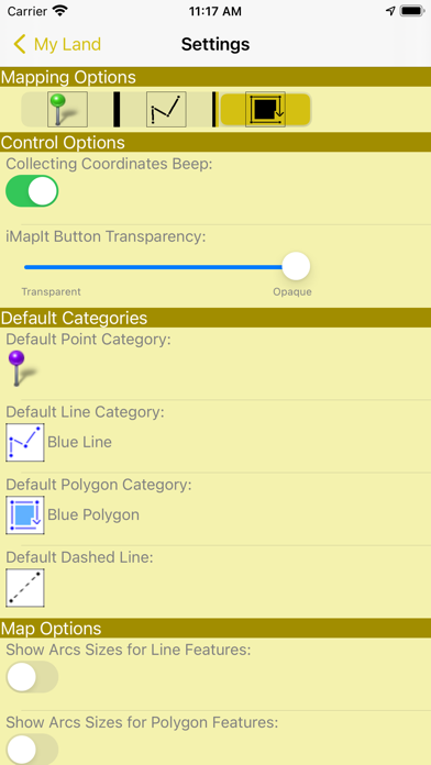
Points, lines and polygons can be represented by various types of pins, different colors and strokes.
Disclaimer on the accuracy of the surveys:
All points, paths or areas are surveyed using the GPS accuracy of your device. This is not a professional precision GPS equipment. So your surveys may vary when compared to the actual dimensions.
Reviews
imapit
CHI MERI
Disgraceful - the previous reviews are spot-on. ?There is no proofreading or QC here. Save yourself that three dollars.
Export kml no good
dsk1000
Unable to open the kml files this app exports in google earth. Corrupt. Renders app useless. Disappointing.
How do you export?
TatooineSky
Really like this app. Couldn't figure out bottom icons initially, didn't realize you can swipe them over to see more, such as the export icon. But once I found it, all was good. It would be nice to see how many satellite it sees. Also it would be nice if you can physically move points.
Awesome App
Bassett90
I am a a civil engineer and needed something quick to gps field data at sites. I tested it out one day with a Trimble GeoXT 6000 and the points were almost identical. I am sure I will run into scenarios where I will need the Trimble but this works well if you just need something quick and dirty to pick up points at a site. Worth every penny!
Can’t Register so Can’t use it!
SJ42x
I thought it was strange that the app showed 3 attempts to register it and said that it wouldn’t work after trying 3 times, but found out that I did need to use more than one attempt. I can’t use the app until after I register it, but it just says “please wait...” when I try to register it, and won’t ever register. So this app is completely worthless. The is no support at all, so I can’t contact anyone to fix it. Looks like it would have been a great app if it worked.