
GIS Pro
| Category | Price | Seller | Device |
|---|---|---|---|
| Navigation | $299.99 | Garafa, LLC | iPhone, iPad, iPod |
GIS Pro is the enterprise version of a two part app suite for mobile GIS users. GIS Kit ($99) is geared toward individual users whereas GIS Pro ($299) is capable of some more advanced, collaborative features that are typical of an enterprise environment (see list below).
FEATURES IN GIS KIT & GIS PRO
- No desktop GIS software required.
- No prior GIS training required.
- Completely offline capable.
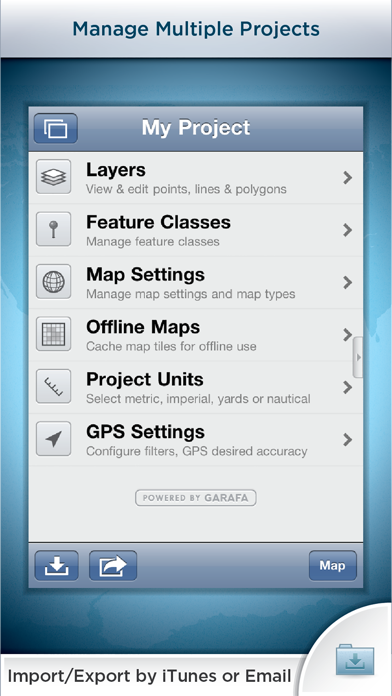
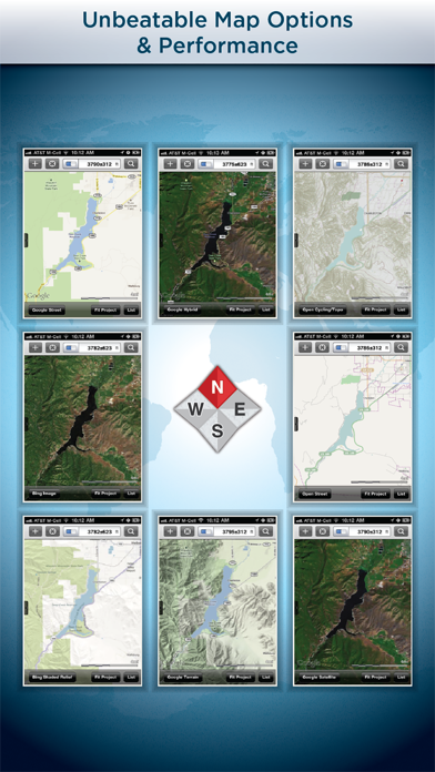
- Cache (download) open source topographic maps, street maps and satellite imagery straight from device.
- Import ESRI Shapefiles and KML/KMZ files including attributes.
- Attribute/form fields include: Alphanumeric (Description), Photos, numerical values, user defined list of values, addresses, websites, date & time, telephone number, check box.
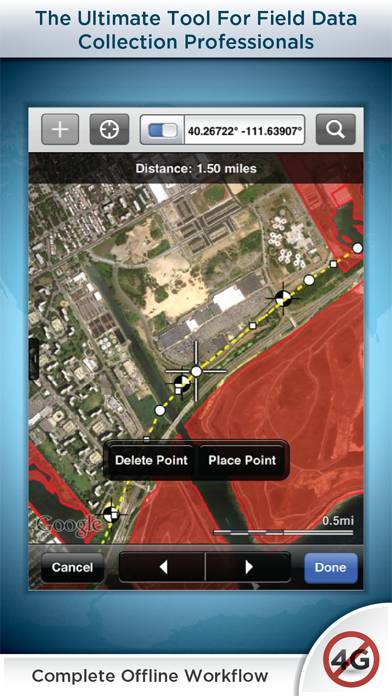
- Easily collect new point, line, and polygon features in the field by GPS or drawing manually.
- Enter attribute values for each feature and/or add new attribute types at time of collection.
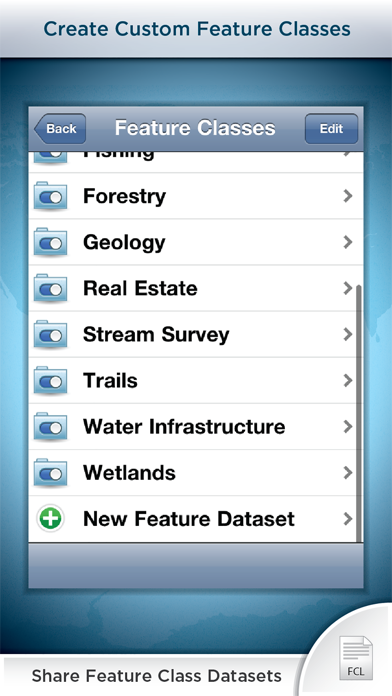
- Create templates of user defined feature classes with custom attributes.
- Comes loaded with numerous example feature templates for professional use in Forestry, Wetland Delineation, Stream Surveys, and Real Estate.
- Import and export data wirelessly by email. Larger data sets can be imported/exported by connecting to any computer with itunes.
- Filter the GPS based data collection by controlling the amount of GPS points by distance, time or accuracy
- Organize by projects and layers
- Best-in-class performance. Tested on iPad 2 with over 1 million point features!
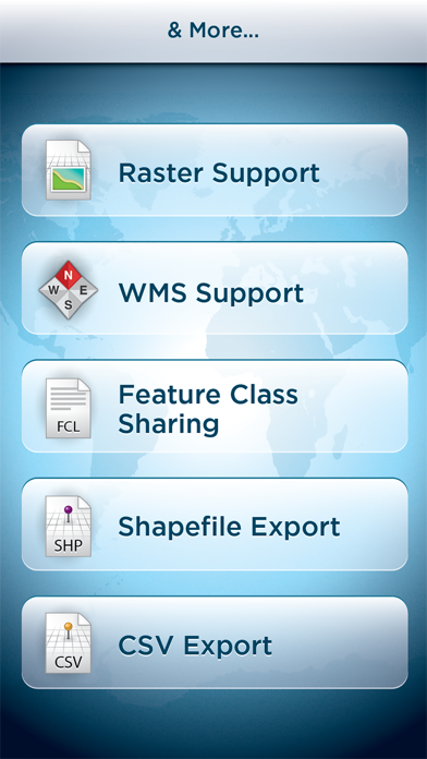
FEATURES ONLY IN GIS PRO
- Raster imagery import & export (GeoTIFF, Worldfile, KML, and even non-spatially referenced images can be imported with in-app 3-point registration)
- Export Shapefiles and CSV files via email or USB with iTunes
- Export, share, and import custom feature class templates with other devices used by your team so there are no conflicts with your features and their attributes.
- Basic WMS for additional basemap options
- Easily convert Shapefiles to KMZ files and vice versa
Documentation and videos can be found using the support link.
IT MANAGERS
Please note that a separate license is required for each user or each device that is used by multiple users. See http://www.apple.com/legal/itunes/us/terms.html for details. Also see http://www.apple.com/business/vpp for information on purchasing in volume.
Continued use of GPS running in the background can dramatically decrease battery life.
Reviews
Great field app
Geo GIS guy
I've been waiting for years for an app like this. It is very practical, extremely flexible, and no training to get going. Loading project imagery or caching images is huge when in a disconnected environment. Our firm is very diverse in field data collection needs and this suits such a wide variety of information. Much easier to use than standard gps systems, you have to just remember this is rec grade gps and not sub-meter. Even then, the manual digitizing ability mostly mitigates that issue. Works well so far, no crashing.
Leif Embertson, River Engineer, PE
Leif Embertson
GIS Pro is hands down the best GIS application out there for Iphone/IPads. I have found the ability to cache maps and aerial photos, easily create feature layers/classes, and transmit field data in multiple formats very useful. With the addition of GIS Pro to my IPad, Trimbles and other other GIS devices are just not as useful as they once were.
Awesome!!
Brian Ranney
Great app! It is easy to use, very intuitive and extremely powerful. I collect spatial data for a living and life just got much easier with this app! I especially like being able to import GIS shape files and create my own feature class templates for customized data collection. I love being able to collect data using GPS locating or placing the data point on an air photo or map. And the ability to export data to kmz files, shape files, csv files and gpx files is awesome! There is no greater spatial data collection app out there.
Geotechnical Engineer
Sarah Hooker
This is an incredibly useful tool for mapping, navigating and collecting data in the field. We used this program to map erosion and landslide hazards along a 600 mile utility alignment in remote parts of the United States. We were able to upload the utility alignment before our trip and cache the satellite images for several miles on either side of the alignment, so that we could still navigate and zoom in on features in the field. The points that are part of the program are very applicable and useful, but also adding points to feature classes when needed is very simple and fast. We were able to walk the perimeter of landslides using the polygon feature and then collect information such as scarp dimensions, slope inclination, direction of movement, etc. All the collected information is then saved together for that point. It is also convenient to be able to take photographs in the same location that you collect data. The quality of the photos turned out well. Once we were back in the office, we downloaded the data directly to Google Earth. We were then able to email kmz files to the client with our data. This saved hours of GIS time in the office. The Otterbox cover is durable and protected the iPad during use. Overall, we were very happy with the capabilities of this app and will be using it for all our future mapping projects.
Great App!
Explosive GIS
This is a great tool. I work in an environment where a good GIS program and mobile on-site capability is imperative to our safety. I found a glitch in the program and emailed the creators who responded promptly and had an update out within a couple of weeks. Great program and great support!
Versatile and intuitive
elpadrastro
Provides clients and contractors a great way to visualize what we see in the field.
New user
Siting Guy
I'm a new user of this app and think its a really good start. It has great import/export and drawing capabilities and a easy to use design. What it really needs though is direction and distance readings when drawing lines and polygons. Also, the measuring tool should also provide direction. This is hugely important for drawing property boundaries. Without this capability, it is dependent on data sets created in more powerful GIS software. With it, this could be an amazing tool well worth the price.
My life just got a lot easier
Pipeline Patrol / GIS User
Still new to the app, but have tested out many features and so far it has met, and often exceeding my expectations. Planning to be used for field data collection on fixed wing, helicopter, and ground missions. An auto tilt feature (so your heading is always up) or even a simple compass along with a current heading display would make this perfect.
Geologist
Aaron Waggoner
I can't tell you how many times this app has come in handy in the field. I use it quite often to mark either existing or proposed sample locations and then email them in a KMZ file to the PMs. It is also nice that when sample locations are revised while a project is underway PMs can send out a new KMZ to be imported while in the field. This allows for nearly real time decision making. Being able to append photos to the sample locations adds another dimension to data collection.
Program freezes
The Larma
The software is good but it has a problem of freezing when im using my ipad! The app will not open wheni tap on it. So frustrating