DX Toolbox
| Category | Price | Seller | Device |
|---|---|---|---|
| Lifestyle | $2.99 | Black Cat Systems | iPhone, iPad, iPod |
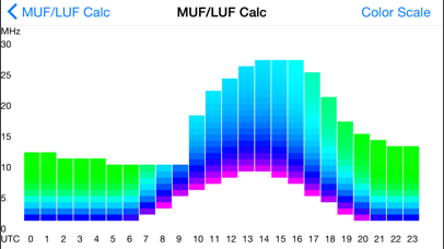


Radio propagation conditions can also be estimated between any two points on the Earth. Graphs of these conditions can be generated for a given frequency or time, and MUF/LUF graphs can also be displayed.
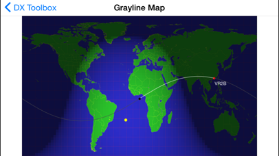
A grayline map of the world is also available. Radio propagation between locations within the grayline region of the world is often greatly enhanced. DX Toolbox's grayline map makes it easy for you to determine where those locations are. Grayline propagation has been used by expert radio operators and DXers for years to catch elusive stations. A plot the great circle (both short and long) path between your location and another station is also displayed, as well as the beam heading and distance. The location of the currently transmitting NCDXF/IARU beacon can be displayed on the map as well.
The propagation map displays the areas of the world where your signal can be heard (or a signal can be heard from), based on the frequency, transmitter power, and current solar flux, date, and time.
Maps showing ionosonde plots of foF2, foEs, and hmF2 data from various locations around the world are available. The MUF and skip zone can be calculated based on foF2 and hmF2 values.
Aurora prediction maps for the northern and southern hemisphere are available.
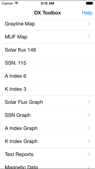
DX Toolbox displays the following important solar and geomagnetic readings:
Solar Flux
A-Index
K-Index
Sun Spot Number
X-Ray Flux levels
X-Ray flares
Solar Wind
Earth's Magnetic Field
Proton and Electron Flux levels
Radio Blackout conditions
Geomagnetic Storm conditions
Solar Radiation Storm conditions
Graphs of x-ray flux readings from the GOES satellites may also be displayed.
The following radio propagation reports and forecasts are available:
WWV Geophysical Alert
27 Day Space Outlook
45 Day AP Forecast
Geomagnetic Data
Daily Geomagnetic Data
Daily Particle Data
Daily Solar Data
GEOALERT
Daily Magnetometer Analysis Reports
Hourly Magnetometer Analysis Reports
Predicted Sunspot Numbers and Radio Flux
Report of Solar-Geophysical Activity
Solar and Geophysical Activity Summary
Solar Region Summary
Weekly Highlights and Forecasts
Current Space Weather Indices
Space Weather Event Reports
Daily Space Weather Indices
Summary of Space Weather Observations
3-day Space Weather Predictions
SEC Space Weather Alerts
In addition, 21 maps of current D Layer Absorption levels are available for display.
Full documentation on how to use the app is available here: http://www.blackcatsystems.com/iphone/dx_toolbox_faq.html
Get your copy of DX Toolbox now, and you’ll always be up to date on current radio propagation conditions.
Reviews
Does not work
dl7aeg
Looks like a work in progress, this app is not ready for release, needs serious work. Can I get my money back?
It works
Jhkayakr
It works good, supplies all the data it says with an online connection. Gray line map is useful. Read the help section in the upper right corner before using and you will have no problems. A more detailed tutorial would be nice though. Geared toward hams, but swl's like myself find it interesting and helpful.
Propagation for Time Calc Crashes
M. C. Jordan
Looks pretty good so far. The Propagation for Time calculation crashes the app hard every time I attempt to use it.
Has the info, but rough around the edges.
MookieC
This really feels like beta software. The interface is bare bones and feels unfinished. In the Setup menu, why do you have to enter your lat/long by hand, when the iPhone can usually figure that out by itself. The purpose of the buttons under the gray line map is unclear. Graphs need titles and legends and descriptions and such. This isn't very useful in its current form. A shame, because I WANT to like it. ?
Meh
McNeight
Contains some handy information, but nothing you can't get from other sources using a web browser. The user interface needs A LOT of work; leaving the program and coming back starts you at the main page again, no access to internal GPS for obtaining coordinates, creating "Custom Locations" rotates your screen whether you want it or not, etc.
Great App
Kyle Boblitt
This app is great and has really helped me get a tactical edge on my QRP operations. It is my go to app when using my KX3.
Not a good iPhone app
Desert Rancher
Many displays are too small to be of value; even enlarging does not fit on screen. Grayline Map displays limited bands 20-10 what happened to 40,80? Map cannot be zoomed/enlarged; location between points is difficult to move or see name of location. Clearly this app is really not meant for the iPhone screen size. There are other apps available which provide real information that give the information an amateur needs for propagation in their location or between points. If this app does that, find it.
Works great.
Mr gamer 507
I use this app quite a bit, mostly to just check space weather, but occasionally for point to point propagation predictions . The only added thing I'd want is something like VOAAREA.