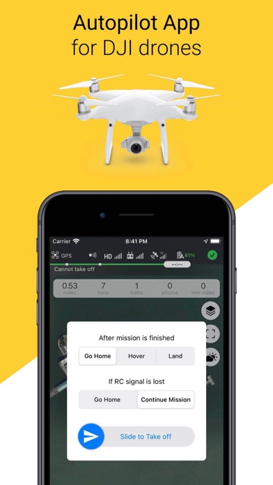
Copterus #1 Autopilot for DJI
| Category | Price | Seller | Device |
|---|---|---|---|
| Photo & Video | $4.99 | Nikolay Leshchikov | iPhone, iPad, iPod |
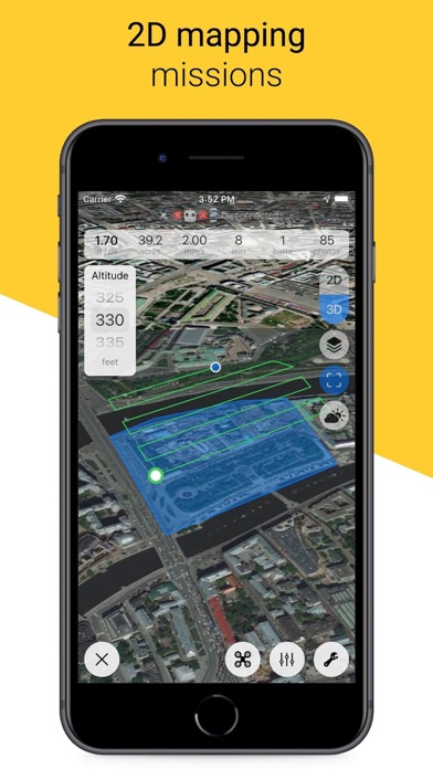
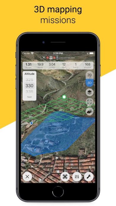
* Area Mapping *
For orthophoto and 3D reconstruction. Draw custom polygon, set altitude, tune overlaps and you are ready to fly with just one tap.
Use Copterus app to capture aerial images and process them with your favorite photogrammetry software (Metashape, WebODM, Pix4D, DroneDeploy, MapsMadeEasy etc) to get orthomosaic maps, elevation and terrain models (DEM, DTM).
- Automatic grid or double-grid flight planning based on camera parameters
- Estimates for GSD, flight time, number of photos and batteries
- Multiple flights for massive areas
- Custom start/finish positions
- Pause mission and move backwards to retake some photos
- Automatic takeoff or start mission after manual takeoff
- Plan beforehand and try any DJI drone and camera to fit your mission
- Land, hover or return after flight
- Go Home on connection loss or continue mission
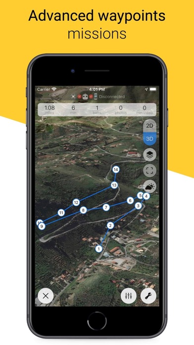
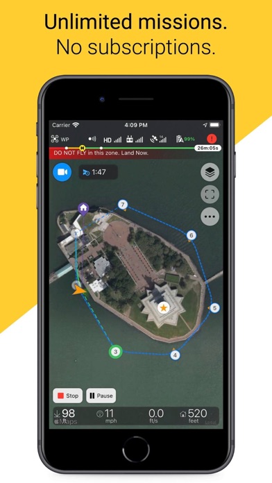
* Waypoints Mission *
For smooth and repeatable time-lapse videos and photos (even seasonal time-lapse), photo reports from the same exact positions, search and rescue operations, aerial monitoring and video surveillance.
Tap desired locations to draw a flight path. Set common mission params, then tune points' altitude, heading, gimbal position and add some actions.
- In-point actions: wait, take photo, start/stop video, rotate aircraft (yaw), set gimbal angle. Up to 15 in each waypoint)
- Round-repeat waypoint actions up to 15 times
- Custom actions timeout
- Point-to-point or curved flight path with adjustable turn radius near each point
- Ability to control drone's speed with RC joystick during automated flight
- Set autospeed to 0 and move drone with RC joystick along its planned path - just like a cable camera
- Ability to continue mission in case of RC link is lost
- Auto-repeat mission up to 15 times
- Go Home on connection loss or continue mission
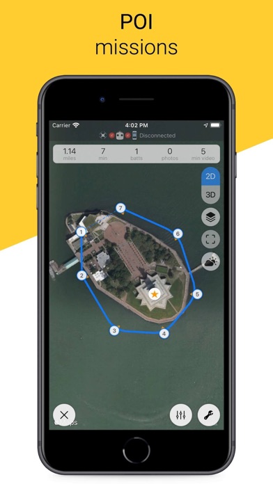
* POI Mission *
- Add point of interest (POI) to waypoint mission
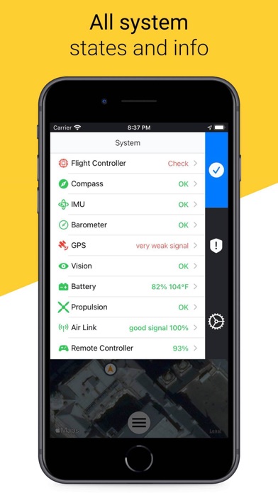
* Drones and Batteries Management *
- All system states and info, errors and warnings
- Batteries health info. Checked and saved on each connection, available anytime
- Multi-battery support
- Save your drones and batteries to track state
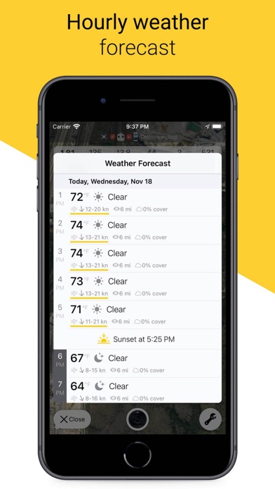
* Weather and Sun *
- Hourly weather forecast with wind warnings
- Sunrise and sunset time
* Appearance *
- Fahrenheit or Celsius
- Feet or meters, miles or kilometers
- All screen sizes from small 1st-gen iPhones SE to big 13" iPads
- Portrait, landscape, upside down, downside up
- Light or dark mode
* Icing on the Сake *
- No logins
- No ads
- No subscriptions
- Unlimited missions to plan, save and fly
- Unlimited drones and batteries to save and monitor
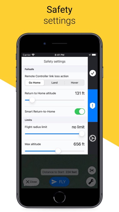
- Easy safety settings
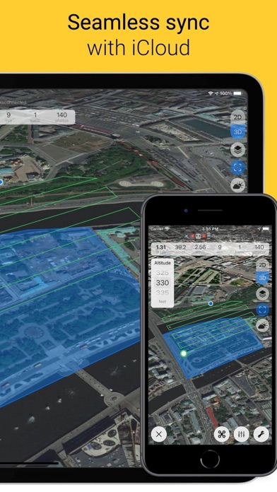
- Seamless data sync between all your iOS devices using iCloud
* Supported DJI Drones *
- DJI Mavic Mini **NO AUTOMATED MISSIONS YET**
- DJI Spark **NO AUTOMATED MISSIONS YET**
- DJI Mavic series: Air, Pro, 2 Pro, 2 Zoom, 2 Enterprise
- DJI Phantom 3 series: Standard, Advanced, Pro, 4K
- DJI Phantom 4 series: Standard, Advanced, Pro, Pro V2, RTK, Multispectral
- DJI Inspire series: V. 1 (Pro, RAW), V. 2
- DJI Matrice series: 100, 200, 200 V2, 210, 210 V2, 210 RTK, 210 RTK V2, 300 RTK, 600, 600 Pro
- DJI flight controllers: A3, N3
- DJI Agras with A3 controller
* Supported DJI Cameras *
DJI Zenmuse X3, X4 S, X5, X5 R, X5 S, X7, XT, XT S, XT2, Z3, Z30, H20, HT20
* Other DJI Drones *
- Mavic Air 2 support estimate in December 2020
- DJI Mini 2 support estimate is unknown
* Not Yet, Coming Soon *
- No Fly Zones
- LAANC
- KML import/export
Please check Copterus app website for more info, discussions, support and tutorials:
www.copterus.app
Reviews
Five stars once Mavic Mini missions are supported! (Now they are!!!)
untaken_review_nickname
Love the app, though I feel it’s lacking functionality without support for the Mini and others Edit: 5 stars, love the update!
Great mapping app
Crapy software
Flew my first mission and it was a little windy but the data collected provided a good mosaic using ArcGiS pro. Flew second mission on calm day and used ArcGIS Pro to mosaic imagery. Results are excellent. Digital Terrain Model match perfectly with the mosaic image. Compared mosaic image results to Florida DOT ortho aerial maps and the mosaic map matched perfectly. Then compared the Florida Lidar elevation maps to the Digital Terrain Model map. There was a slight constant bias, but besides that the elevation matched. The elevation bias was due to the elevation reference between GPS reference and Lidar elevation datum reference.
Magic Air 2S not supported
dydrone
Purchased app and found that the newer Air 2S is not supported. Kind of bummed, but I get that it is a pretty new drone. Looking forward to an update!
Hey Dev, any AIR 2 S update planned later?
RTGRWL
This app is packed with features, and can’t wait to use with my Mavic Air 2 S if there becomes an update available later down the pipeline. Have several others I know waiting to get this app as well and are just waiting it out until it supports the A2S. Hope it will be possible! This app rocks!
Awesome, but watch out for notifications!
Braino07
I just flew a couple test missions, using my Mavic Air. Like many; I am waiting for DJi Air 2S support. I must say however that I am very impressed! I set up a mission to fly over a local school (it’s Saturday and nobody is around) and found the UI real easy to navigate. The drone flew its mission admirably, nice bell sound as each waypoint was reached, and it returned home when done! Quite nice! Near the end of my mission a notification came through and I accidentally tapped on it. ? the result was Copterus lost the drone and guess what - it LANDED right where it was, in the school field! Fortunately it reconnected to the remote controller, and After a few frantic taps on the fly command and it launched and returned to home on its own. ??? But the whole time I could not tell what the drone was doing: the app was essentially frozen, but the remote did the RTH beep, so I just waited patiently. ? It wasn’t until I looked at my flight logs that I saw where it landed, took off, and returned! Word of advice: turn off notifications when flying a mission! Maybe even turn off cellular data! The only thing I would like is automated camera/gimbal focus. It would be nice if I could set a ‘Point of Interest’ (For example, the school building, or a baseball Diamond) that the drone would remain pointed towards while flying. I know gimbal pitch may not be easy but general direction would be much better than trying to control this manually, you can, but it will never be smooth… In all - I am VERY impressed & am telling my friends! ?
Need new firmware for AIR 2s
Charm608
Is there new updates and compatible firmware for mavic AIR 2S?