
Chicago L Metro Map
| Category | Price | Seller | Device |
|---|---|---|---|
| Navigation | Free | Mapway Limited | iPhone, iPad, iPod |
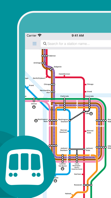


Whether you just need to get from A to B or are planning a sight-seeing trip to the 'Windy City', this app will give you all the information you need to get around on the Chicago L. Free to download, Chicago L Map is the perfect transport app.
• Simple, stylish and intuitive to use when travelling around Chicago.
• Choose the route types that are right for you, either by the fastest route or the route with the fewest changes.
• Route planner which will calculate your route telling you how long your journey will take and how many stations you will pass through.
• Easy to search for a particular station or find the nearest station to you.
• Includes a clear map with pan and zoom enabling you to easily view while on the move.
• Live official Twitter updates from CTA.
• Uber integration allows you to book a taxi within seconds and continue your journey after using the Chicago L.
• Unlock additional features such as Walking Routes and Remove Adverts.
We make apps for cities worldwide so if you’re also thinking of visiting Washington DC, LA, New York or London make sure you check out our other metro apps, available to download for free in the App Store.
Join us on Facebook at www.facebook.com/MapwayApps or follow us on Twitter @MapwayApps. Let's stay in touch.
Plan. Route. Relax.
Reviews
Outdated
Stephen Hanafin
At the time of writing, this app hasn’t been updated in about 3 years, so it doesn’t know about changes to the CTA, like the new Washington/Wabash station. Otherwise it works perfectly fine.
Love it.
Inklefarter
I use this app extensively when I visit Chicago and it gets me from Point A to Point B.
Almost useless
LuCyPh3r
While it has a nice map overview on where to get on/exit, there are NO schedules.
Terrible
Schupman
This App exists first and before anything else as an ad delivery mechanism. Only after this, did its developers turn to its ostensive end of providing a map and cta routing info. The routes it supplies are designed according to some infernal logarithm and the map itself is booby-trapped with a weird combination of glitches and more ads... Try another one Chicago!
Not the same caliber of the NYC app
Doofendoofer
I just got back from NYC and loved their app for getting around the big apple, but the Chicago version is missing most of the features that I loved about the NYC one. I really wish that there would be a normal map underneath the subway map so that I could figure out which stops work best for me.
Good App
JerryK113
I am enjoying this app. Since I retired this app has saved me time in planning my daily trips around the Chicago area.
Good, just need to update map
Personnnnnn?
Overall a very useful app. The only flaw is the map. The city map with the street names should be placed under the subway map the way the nyc one is to make it easier to choose the station for where you need to go.
Fatal Flaw In Route Planning
iDirkF
This could be a very useful app, and it is to some extent, but it has a major flaw. Yes, you can plan a route by entering a starting station and end station but the app only gives you current time results. There is no way to select the day and time you wish to travel. This makes the "route planner" basically useless for planning a trip in advance. Huge oversight in design and why I give only two stars.
Not s bad app to quickly get your bearings
Rudifieugifjdufjcickgoglgkcwc
I used the app the last time I was in Chicago, so using it once a year takes a little acclamation. The app has improved since my last usage, it would be nice if the step by step were a little clearer (matching route and train to end line destination to make sure you're going in he right direction). Otherwise good stuff.
Good but could be better
Tallahassee traveler
I was new to Chicago. I used the L to get around to all the touristy sites. I really like the trip planner and the easy to follow stop designations on the Application. I liked how i could say I was at Grand Station and then chose a location like Wrigley Park, as a desired location i needed the CTA to get me to. However it would have been nice to have a way to see the cross streets laid on a map, beneath the L stops. I had to open a normal tourist map on one page, and then ur CTA application on another, to figure out where i needed to be. Maybe i just missed this feature, but if not, it would be a good idea for a future tweak.