Bike Tracks
| Category | Price | Seller | Device |
|---|---|---|---|
| Navigation | $1.99 | Core Coders Ltd | iPhone, iPad |
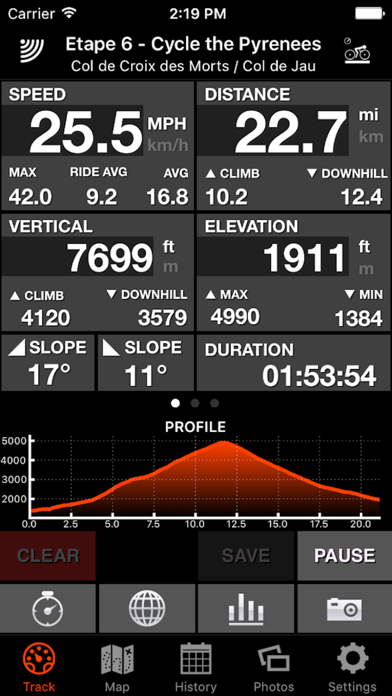
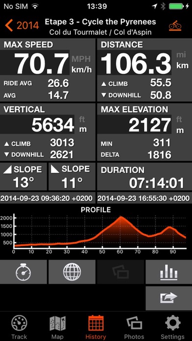
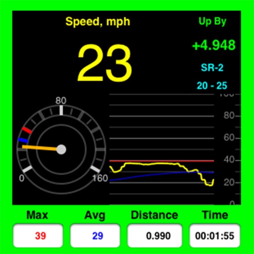
Designed specifically for cyclists who want to go long and require all their cycling statistics. Press “Start” and begin recording your cycling adventures.
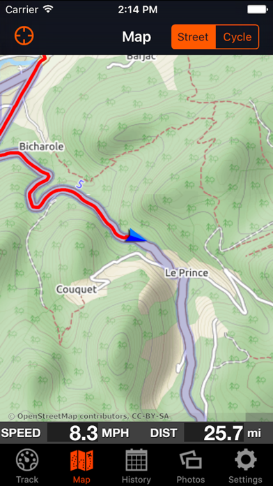
Easy to read statistics available in different formats, offline cycle and street maps facility and 3D Maps.
Battery efficient technology allows all day recording, no data or phone signal required for recording making Bike Tracks ideal for those long cycle rides and where data roaming charges apply. (1)
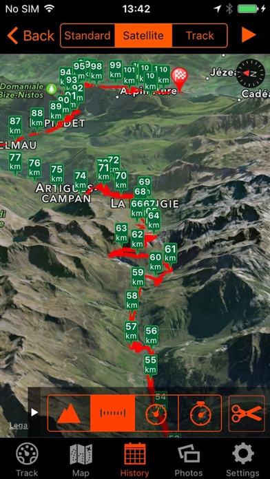
Share your cycle rides on social media or export directly to Google Earth directly on your phone.
(1) Where data roaming charges apply remember to set Data Roaming Off see iPhone User Guide for more information.
This app may use your location even when it isn’t open, which can decrease device battery life.
Reviews
Getting it to start
ghkgxvvjyv
Having trouble getting app to start. Will not ST tart at the beginning but 5-10 minutes into the ride it will. Frustrating.
Needs motor cycle option
Craig199
I use it to track dirt bike and dual sport rides, but the closest choice it has is mountain biking. Works great, would rate 5 stars if there were a motorcycle option.
A good app with great support
John in CB South
Clean UI and simple to use with great depth of features. It’s a nice way to log ride without the baggage of other apps—Strava and Map My Run. The support is phenomenal for a low-cost app. I had a couple questions and they took care of me quickly. Highly recommended!!
Good app
Flighle
It’s nice, it hits all the necessary functionality points. I have Ski Tracks, however, and the data that app exports to Health.app is so much richer than this. I’ll keep both, but look forward to seeing this one approaches feature parity.
Love it
Hiker Bro
I’ve been using since 2016 and have about 9000 miles tracked, both on pavement and mountain biking. Does all I need it to do except pick me up after I crash
Everything you need
Edbikeski
This app is fantastic! It has every stat you could possibly want. I use it for cycling and hiking. And the gps locator was perfect when on a hike along the PCT we found an abandoned campfire still smoldering with flames spreading. After 200 trips to the nearest pond to fill water bottles we hiked miles to get cell service. I was able to contact the forest service with the exact coordinates who later arrived to be sure it was 100% extinguished.
Great bike app
Nkdc
I’ve been using this app for years. For both mountain and road biking. And for hiking! Easy to use and lots of fun information.
Close to perfection
spodaddy
Great app! If you're a skier you need these guys' SKI TRACKS app. All in all, this bad boy is almost perfect - especially for a phone app. 99% of riders don't need a GPS if they have this. A few improvements I'd love to see: 1)Position plotting - selectable intervals: I find that on tight switchbacks it misses turns because the interval is too long. It would be better if you could select the interval according to your riding style, knowing that this will affect battery life. 2) Proximity sensor: SKI TRACKS uses the proximity sensor. Why not BIKE TRACKS? 3) Position tags: It would be sweet if you could tag the beginning and end of sections you wanted specific data on - and if this could be done with voice-recognition that would be ground-breaking.
Great app, well worth it, almost perfect
Kayakchop
I agree with the above reviews. It tracks very well, multiple rides on same trails are pretty closr to each other. Impressive because a lot of the trails are in canyons where service isnt that reliable. Occasionally the plot points are too far apart and s-turns at speed get straightened out. I also got a response from the lead developer and he is all about input and responds accordingly. I hope a furure release adds the ability to drop placemarks so you can split up a ride into your own data blocks. It tends to miss label descents and ascents but thats a small detail. Awesome app! Get it and get out on the trails!