US Public Lands
| Category | Price | Seller | Device |
|---|---|---|---|
| Travel | $2.99 | Two Steps Beyond | iPhone, iPad, iPod |
These are lands that are held for all Americans.
Up until now, there has been no quick & easy way to retrieve the boundaries of these properties without carrying physical maps, books, or slowly digging deep online.
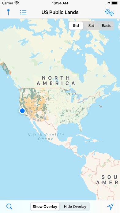
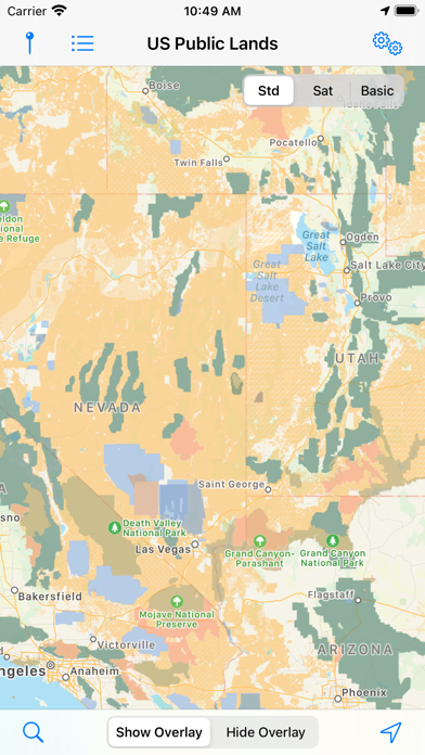
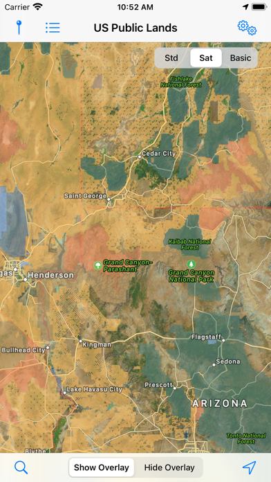
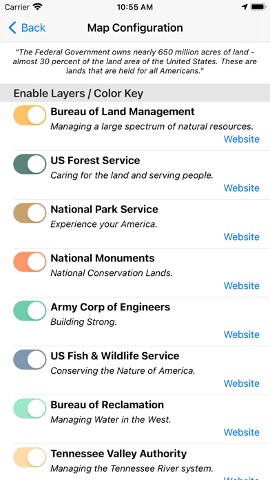
Included in this app are on device (fully works offline), individually selectable & beautifully colored layers for all of the properties administered by the federal government that are more than 640 acres in size:
- Bureau of Land Management (BLM)
- US Forest Service (FS)
- National Park Service (NPS)
- BLM - National Monuments
- Army Corp of Engineers (ACOE)
- US Fish & Wildlife Service
- Bureau of Reclamation
- Tennessee Valley Authority
- Department of Defense (military bases & installations)
- Other (National Laboratories, Test Sites, etc...)
Key Benefits & Features
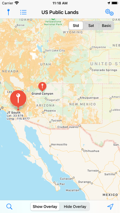
- Know which US agency owns and operates the land you're on or are heading to. Use the "Layers" icon to select which agencies you want displayed to create your own custom map. (Hint, the toggles are color coded to the color each layer is displayed in.)
- Links are provided to each agency's website within the app, so that you can further your research as to what land use rules apply for each public land type - such as permits, fees, activities allowed, and limits of stay.
- Map layers are stored on device - no internet connection required.
- Be sure to turn on the 'Basic' base map to see the US Public Land labels for each land area. This base map layer is also stored entirely on your device, and can be utilized if you do not have an internet connection or would like to conserve bandwidth.
- If you have an internet connection, you can utilize standard and satellite view maps as well as the base layer underneath the public land overlays.
- A boondocker's assistant - by turning on the Satellite view map, you can better scout out trails, roads and boondock camping locations within the boundaries of the public land resources. (Please note, this is not specifically a campground locator app - but you can combine the boundary maps with satellite imagery to scout out where there are clearings and signs of dispersed campsites. For an example of how this app can help with finding boondocking locations, see: http://www.technomadia.com/2014/09/finding-magical-boondocking/)
- Quickly toggle between 'Show' and 'Hide' via the "Map" icon to more clearly see satellite images below.
- If you have GPS access on your device, click the 'Locate Me' icon to show your present location - know what type of land you're on right now!
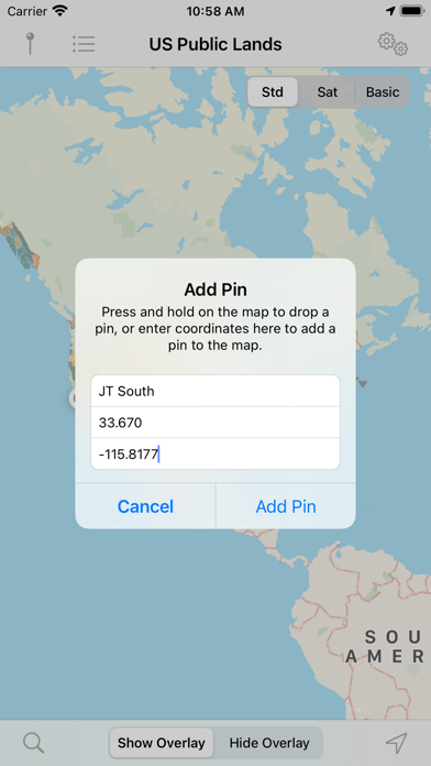
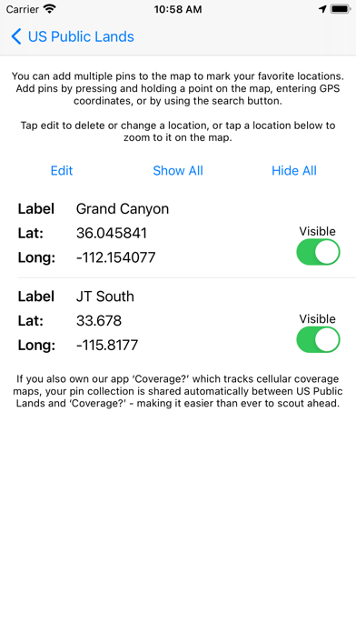
- Built in search tool locates anything on device maps supports (requires internet access) - including cities, states, zip codes, addresses and points of interest. A pin is dropped at the search location.
Now the US Public Land boundaries can be in your pocket!
Thank you to the National Atlas of the United States for providing public domain raw map data that we’ve been able to apply our proprietary rendering technology to create an interactive overlayable mapping & navigation tool. We will update our maps, when they update they theirs.
Please note, the National Atlas maps only report to the nearest 640 acres (or about a square mile). This is obviously not detailed enough to be precise around borders, or for determining where private inholdings within public lands are located. US Public Lands should only be used as an overview, and you should always confirm more precise details by consulting more detailed maps, local field offices or the websites links within the app. And we of course can make no guarantees as to the accuracy of the maps provided by the National Atlas.
Reviews
Might get you in trouble!
Horsefacemcgee
This app is much to vague on where public land begins and private ends. I tested this app in southern colorado against areas I knew were private and found it showed them as public. It is nothing more than a spit ball guess on where boundaries are and when it comes to trespassing I think a person needs something more accurate than this app.
Worst app ever and absolutely useless!
Lucho1930
This app is a complete fraud. Nothing on this should be called an app. I want my money back!!!
Fabulous!
Wheelingit
Been wanting something like this for years. A "must have" for everyone looking to camp on public lands.
Outstanding app
Keiscokr
As expected, Technomadia comes up with another great addition to 'Must Have' apps for anyone traveling and looking for a spot to pull over and enjoy this great country of ours. Very few developers make apps that I will just buy. I do that with Technomadia, if they write it - I buy it as they are that good. Thank-you for filling a void in the RV/Camping/Travelers marketplace and lifestyle. Keep up the great work. You are appreciated in everything you do.
Don't Trust to Avoid Trespassing
Cats&kittens
Thought this would be a good app to use for hiking fishing and hunting public land. Unfortunately, it is not even close to being accurate ad to the actual borders between public and private property. Don't know why anyone would find it useful without a reasonable degree of accuracy. If you trust it, you will likely end up trespassing on private land.
Excellent
Sandsys
I love that this app along with my iPad's internal GPS capability can tell me at a glance if I am somewhere it is OK to stay overnight in my self-contained RV. I also love that Technomadia reads my mind then develops an app to fit my wishes.
It is OK
rfcntwo
Bought this due to a rave review by someone else. To me this is a work in progress and not finished yet. More of an intellectual curiosity app with crude definitions of space related to the map. When I try to figure out where this might be useful compared to other maps I just don’t come up with much. Campwhere, which I also own has similar boundary designations and also tells you where public campgrounds are located. Allstays also defines essentially the same things with a huge amount of useful data. This said, the app cost is very small and I don’t mind having it. But more info that is useful would be nice.
Can't rely on at all
Golfer Bruce
I always read the reviews BEFORE I purchase an app, but not in this case based on reviews from fellow RVers. A quick check of a BLM area near my home shows that the maps are not even close...miles off in places. You could never count on this app to determine if you weren't trespassing on private property, so what good is it? It is no more helpful than any other sources that generally locate Govt property. Sorry, but I need my money back.
Excellent!
Hipskipster
I haven't used any other app of this type to compare it to, but I use this app all the time and it works for me perfectly. I work out on public lands and I use it to determine if I am well enough inside BLM lands to walk some of my bird surveys. It is so much easier than pulling out a big folded map, then determining my location. This app determines your location even without service and is easy to use. Thanks to the creators!