TsunamiEvac-NW
| Category | Price | Seller | Device |
|---|---|---|---|
| Utilities | Free | NANOOS | iPhone, iPad, iPod |

*TsunamiEvac-NW app developed by the Northwest Association of Networked Ocean Observing Systems (NANOOS)
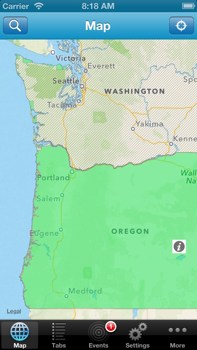
TsunamiEvac-NW provides you an at-a-glance view of where the tsunami hazard zones are along the Oregon and Washington coast, and allows you to map whether your home, work, school, etc. is located in a tsunami evacuation zone or not. To help you develop and plan your own evacuation routes, TsunamiEvac-NW enables you to save your current position or points of interest via GPS or address look-up.
As an important tool in preparing for a potentially catastrophic local or distant tsunami event for residents or visitors to the Pacific Northwest coast, TsunamiEvac-NW also displays the locations of places that will be of critical importance prior to, during, and following a tsunami event, including schools, bridges, assembly areas, and various local government buildings.
Features:
o Up-to-date tsunami information published by Washington and Oregon state agencies and emergency managers, including evacuation zone maps, location of features of interest, and additional tsunami information for the public
o Access to the most current tsunami warning bulletins from the West Coast and Alaska Tsunami Warning Center
o Find a location by either address or GPS
Reviews
Needs to be updated
PNW iPhone
I loved this app ... until Apple did too many upgrades and the app stopped working
Not quite ready for prime-time
PDXHobbes
I applaud this effort to put information about tsunami danger into the hands of more NW residents, but the application does not seem to work as intended. From the descriptions, I would expect to see a map with colored areas representing tsunami hazard zones. Instead, all I have is a map. No amount of tweaking with the settings lets me see any sort of tsunami hazard info. When I inadvertently tapped the locator icon, iPad asked my permission to allow the app to use my current location, but because I was in the Willamette Valley at the time I didn't allow it. That was my mistake, but now there is no way to enable the feature. Tapping the icon doesn't give me another opportunity to allow the location feature, even after closing the app and restarting. Perhaps this will time-out and I'll get another try, but it would seem wise to give some method to address this. It's also surprisingly easy to get lost. By that I mean that the map tends to jump wildly when switching between apps, even when only using icons to switch apps and not swipe gestures. I ended up looking at South America, and on another attempt the program opened with a blue screen......which I presumed to be ocean. Pinching down brought nothing into view, so I decided to scroll one direction. After a while I found land. It was Spain. That ought to be a place safe from Pacific tsunamis. That simple assumption is more useful than the lack of any useful data I've managed to get from the app so far. I really hope that more development will be put into this app, as it could ultimately save thousands of lives. That's probably more than can be said for Angry Birds.
Still needs some work
Bzawesome
I was excited about this app as it is one of those things you hope you never need but if you do it needs I work perfectly. I installed the app and went to the bulletins sections and inadvertently tapped on it. It pulls up the keyboard and froze. Only way out was to delete the app and reinstall. Great idea and 95% there but still has some bugs
Great Resource!
PDX Dad
This app is great. The bugs mentioned in the few reviews must have been fixed as it works perfectly for me. I tested it out while camping at the coast in Nehalem Bay State Park and it worked flawlessly; specifically, the "entering and leaving tsunami hazard area" signs matched perfectly with the map as we were driving up and down the coast. Regarding current location: go into settings>privacy>location services and select "on" for this app (scroll down to find it in the list). I love the "center map to location" function in settings. It allows you to scroll/swipe ahead to plan your route, but then automatically snaps back to your current location. Room for improvement may include the brochure links in Tabs. They should be updated to display the latest 2nd generation maps; the few that are currently available at least (e.g., Nehalem Bay). Looking forward to future updates...
A great start!
TelcoDude
The app does a fair job of mapping the danger regions. Good to know I'm just outside that major area for a tsunami. Hiwever, the app is NOT built for the iPad (SHAME) and it very ugly when used on one. The maps also redraw VERY slowly. I'm on a 20MEG DSL line, so it's not my end. Good start. Let's see how it grows up.
Good app
PHEPman
If you go into setting and change the transparency to about 65% you can see all the map detail. I use hybrid to see where the affected businesses, healthcare facilities, schools, etc are. As a preparedness coordinator it allows me to show my colleagues where their sites are in relation to the tsunami zones. Nice tool.
Links to brochures don't work
Bshopper63
The map is really good but the links to the brochures in Oregon don't work.
I'm glad to have it as a tool.
ownedbychickens
I live in a tsunami zone, it's nice to have this handy app.