Solocator - GPS Field Camera
| Category | Price | Seller | Device |
|---|---|---|---|
| Navigation | $0.99 | Civi Corp Pty Ltd | iPhone, iPad, iPod |
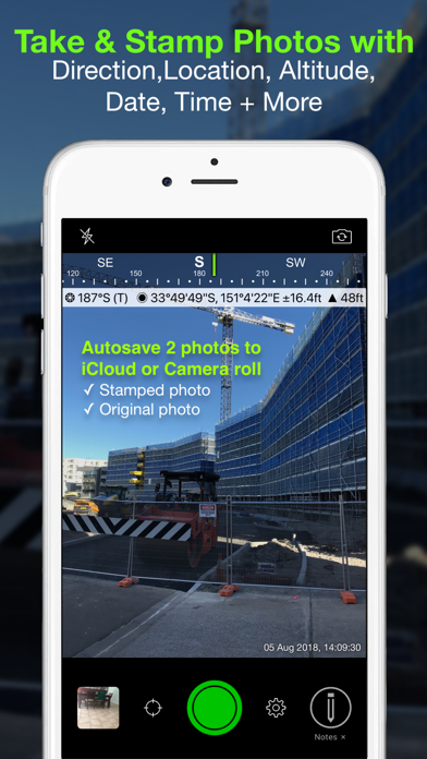
TAILOR THE INFO YOU CAPTURE
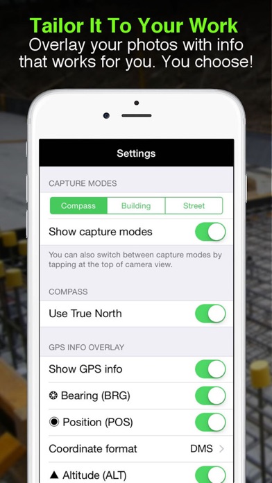
You can choose what information you want to overlay on your photos to suit your fieldwork.
Choices include:
- GPS Location (Latitude & Longitude in various formats) ± Accuracy
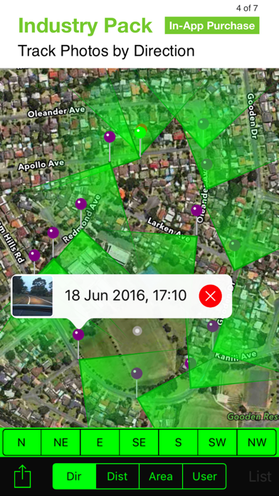
- Compass Direction – Bearing
- Altitude (Metric & Imperial units)
- Date & time
- Show Compass
- Show Cardinal points in Building mode; e.g. North or South Elevations of a building face.
- Option to use abbreviations or Unicode characters for direction, position and altitude.
WORKING WITH CAPTURED INFO
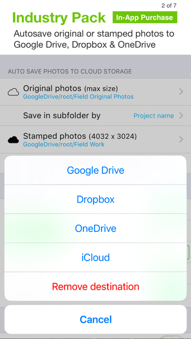
- Options to take and auto save two photos to Camera Roll at once; one with stamped info and the other as an original high res photo.
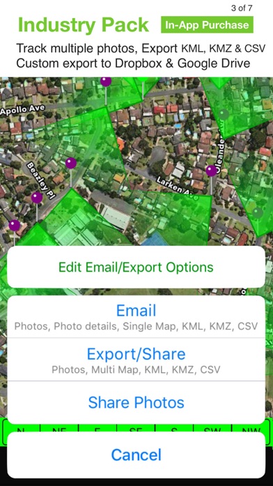
- Photos are sorted by time, location, distance from current location and by project name (if Industry Pack purchased).
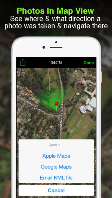
- View photo direction and location in map view and navigate there
- Save photos with metadata in Exif format to camera roll
- Share photos on Facebook & Twitter
- Email photos from within the app including:
• Exif metadata
• Compass Direction
• GPS Position ± accuracy
• Altitude
• Date & Time taken
• Street address (if selected)
• Elevation of building face viewed (if selected)
• Links to maps so receiver can navigate there easily
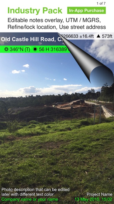
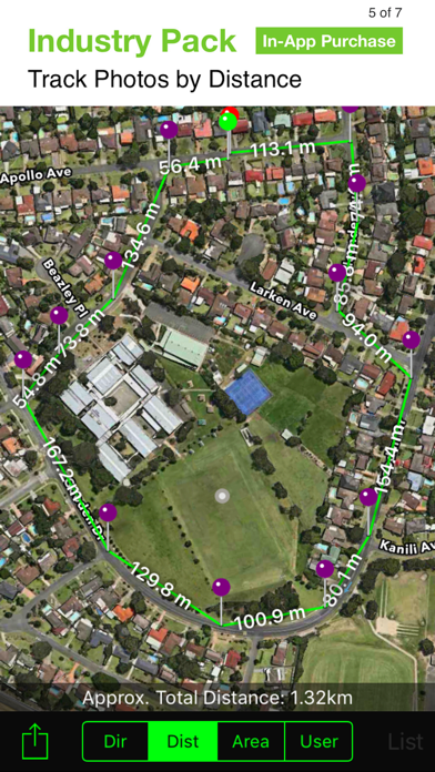
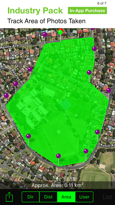
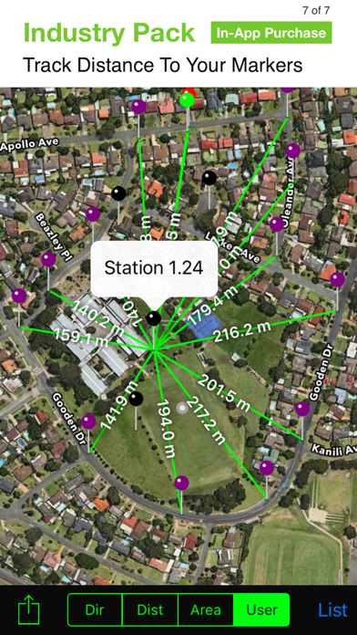
INDUSTRY PACK (In-App Purchase)
REFINE AND LOCK GPS LOCATION
Ideal for those working in and around buildings; to improve your GPS location. You can also use it to lock the position of the asset or subject you’re photographing as opposed to where you’re standing.
EDITABLE NOTES
Stamp your photos with "Project name" & "Description". The project name field could be used as job or policy number etc. You can also go back and amend project name or description or just add the notes later when you’re in the office.
PROJECT NAME USED AS FILE NAME PREFIX
Photos taken with project name at the time of capture are saved with prefix, which works with photos emailed. Photos with a project name will also be sorted and grouped by project name. Project names are also automatically used as email subject lines.
SWITCH OFF CAPTURE MODES – GREATER FLEXIBILITY
Switch Compass, Building and Street modes off and just show GPS info bar on top of photos. Gives you more flexibility on what and how you overlay info and show more of the photo.
YOUR WATERMARK
Customize your photos by stamping your own watermark. e.g. company name, team or photographer name.
STREET MODE
Selecting street mode overlays photos with street address.
Email KML file of photo location
Reviews
Agreed - Near perfect
*NovanoD*
This app is awesome. After working through the settings it’s so easy to export or share. Easy to describe each photo on the fly. So many great choices for how you want to stamp these photos and send them off! Thanks!
Scaling issue on iPhone 12 mini
tyiigdrcdj
The camera shutter buttons are off the bottom of the screen so you are unable to take photos.
Fantastic!
CogsFam
I’ve been looking for an app like this for a long time. Sadly, too many are either too simple or far to complicated and have terrible photo overlay graphics. That is, until Solocator! What a great app, everything you need and nothing you don’t. So easy to use as well, and they even thought of things that I didn’t know I needed. Oh and the price, even with the Industry Pack, total steal! Very well done, thank you!!
Update made labeling measurements difficult
gpcswan
I used to put in factional measurements, since (I’m assuming update) then I can only use a decimal and write out what units. Basically the use of /‘“,. Plus others is no longer possible. If you can make it so I can write 1/8” instead of .125 inches. I’ll change my rating to 5 star.
Photo size doesn’t work on IPhone 12
i hate bits and bytes
I have been using this for over a year now and it was perfect for what I needed. I have changed to a new IPhone 12 and now the unlabeled photos are not size adjustable just the photos with the coordinates on them.
Very helpful for my field work.
Wild Rice 40 cm
My work takes me out to remote aquatic areas for various surveys and inspections. I take lots of pictures of plants on recon and having the ability to map routes, plant taxa, and locations/boundaries of plant taxa via GPS/GIS integration is very useful. And the price for all options is very reasonable. Very useful and user friendly for my purposes. Thank you!
oh wow...
EXTRA-ECCLESIAM-NULLA-SALUS
Burns me up when developers stop supporting apps with normal progression updates, then want to “charge” for “enhancements”. I realize developers have to eat, but so do I. Why can’t these people just develop their product - make it a GOOD product, and have its self sold on it’s own developed enhanced merit?
Works well for what it was intended
rev314
I really like using this app as a geologist. Recently I purchased the industry pack which is a good value for my fieldwork needs. The developers addressed my questions quickly and clearly which was a good value on top of the app itself.
Almost perfect
FrisbeeFool
Wish Solocator had the ability that to take photos by time delay and I wish the app was compatible with my Ubeesize Tripod Remote as the remote is with the default Apple Camera App on the same device.
The best GPS camera app ever
iran bad boy
This app is one of the best app and moslty the industry pack is really useful for those who want to save the coordinates and the addresses of the places which they take photos . But one thing which i really hope the developer add in the future that, beside getting the address, coordinates etc in the CSV report, we could get thumbnail of photos in the table as well.