Skycatch Flight App for DJI — Drone Flight App
| Category | Price | Seller | Device |
|---|---|---|---|
| Business | Free | Skycatch, Inc. | iPhone, iPad, iPod |


Fully compatible with: DJI Phantom 3 (Advanced, Pro), Phantom 4, Inspire 1, and Inspire 1 Pro . Use your iPhone 5 and newer, and all sizes of iPad.
Safely fly your mission with just a few taps — no professional experience required. Skycatch activates your DJI drone for automatic take-off, flight, image capture, and landing.
Upload your images for cloud processing into 2D & 3D models, which can easily be viewed, analyzed, and shared using the Skycatch Dashboard.
For over three years our customers in construction, mining, utilities, and energy have used aerial data daily to save time, money, and reduce costs and common oversight. Now you can too.
>>> "Using Skycatch tools helps increase field productivity related to material staging and site logistics by up to 3 hours per week.” — Scott W, DPR Construction
Use this app for a wide range of jobs:
- Surveying and volume measurements.
- Track progress on a job site.
- Make better logistics plans with an aerial map.
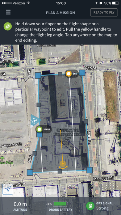
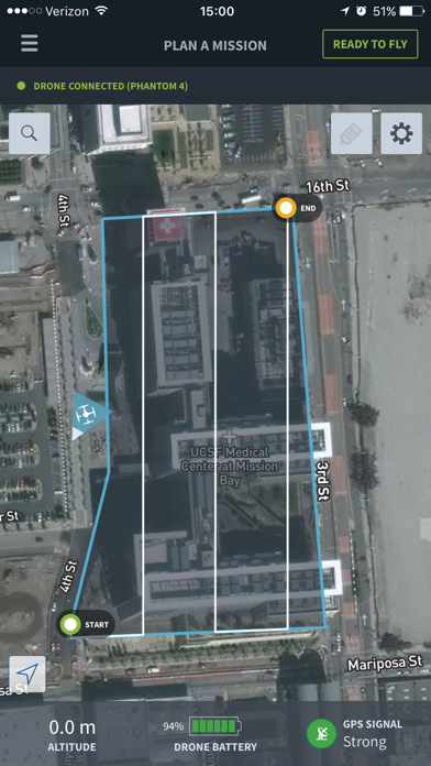
How it works:
- Outline the area you want to map and let the app take care of the rest (altitude, airspeed, waypoints, routing, image overlap).
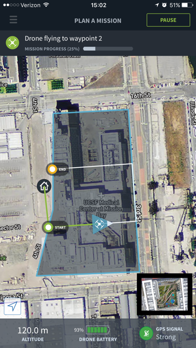
- Autonomously takeoff, fly, and land; upload images to the cloud where Skycatch processes the data for you.
- Post-flight — view, analyze, and share your data in the Skycatch Dashboard: share annotations, overlay BIM & CAD files, and more.
Key features:
- Guidance provided in-app at every step — no professional experience required.
- Quick flight execution — outline the area to be mapped, upload the mission to the drone, monitor its progress.
- You set the output resolution — the app calculates waypoints, altitude, speed, and overlap automatically.
- Flight direction control — modify the direction/heading of flight path; use this to set the direction of flight relative to wind, terrain, obstacles!
- Multi-flight missions — plan the entire area once. After battery swap, tap Continue to pick up right where you left off.
- Live video feed – see live video feed from the drone's camera.
- Summary flight stats – keep track of your work with shareable total stats on number flights, flight time, acres mapped, and number of photos captured. Share with clients and teammates via social media and email.
- Automated map processing in the cloud.
- Access completed maps directly from your iPhone and iPad.
- Save mission plans and avoid re-planning — perfect for multiple sites and recurring data capture.
Skycatch gives you the power to capture aerial data and create actionable intelligence to help people operate faster, safer, and smarter than ever before.
Reviews
Not worth the time
dronejohn
Tried the app. It does have a simple UI which I like. It doesn't do very much when compared to the real players in this market (pix4d, litchi, dronedeploy, etc.). It seems like skycatch noticed that nobody needed a battery changing robot and is now trying to pivot to cloud processing and DJI drones. The price also is ridiculous. One other thing is I was wondering who were these two 5 star reviews that liked the app so much. I looked up the user name and it seems it's the founder of skycatch. Kind of lame :(
P4 & inspire support, yes!
ieditor
Great flgt and map app. Glad for the new support for P4 & Inspire. Like I said in the past review, app is really easy to use.
The Best User Experience & Features!
Syed Reza Ali
I've been using Commander to plan drone flights and fly in the field and it's an amazing app that delivers a clean and very friendly experience. For anyone getting into fly drones this app is a must have. Commander's ability to create precise flight areas is what I love most. You can make sure you don't go into areas you shouldn't be all the while mapping everything in your flight path very carefully. It's ability to store missions is super useful as well. I love that they have thought out everything from splitting the flights into multiple routes (so you can swap batteries) and storing your progress in a mission so you don't waste any time! Thank you Skycatch! You guys rock! Keep making awesome apps!
Super Easy to use!
Nick655321
I'm kind of a lousy pilot since I'm still learning but this app made making a map really easy. You don't even really need to know how to fly a drone. The map was ready in a couple hours and I had a cool new view of my local park.
Needs work, they need to see what the competition has to offer!
Civil Guy
Planning a mission is simple but tells you nothing about total flight time, number of batteries, number of pictures. Can't change the flight direction to accommodate for the direction of he wind. Lots of little things are missing. Can't even change the size of the area once you've set it up. Wish I had saved my money there are way for mature and better mission apps out there! Also needs to let you calibrate the compass prior to flight.
Disappointed
PhantomInPA
I'm a contractor that has started using drones in my business. Gave Skycatch a try and was pretty disappointed. Lots of bugs, slow processing, light on features.
Best mission planner
Drone pilot Dave
I’ve tried a lot of mission planners and this is by far the most well design & easy to use! Really wish I can change leg direction, but their support says it’s coming in the next release. I flew a short mission over the weekend and uploaded to the Skywatch dashboard yesterday, got an email saying it was done and a link. The quality was really good, better than what I’ve seen on other sites. Not ready to pay for a subscription yet, still just testing it out but top choice so far.
Great tool to not worry about anything else
Amateur Droner
I don't have much experience with these types of automated missions, so I was pretty nervous from the get go. Being acrophobic and starting a mission from the rooftop wasn't helping either, but with a couple of more experienced friends and commander, everything went smoothly: Just drew the mission, armed and let it fly. Everything happened nicely: the phantom flew away, did its thing and landed back where it was supposed to, so alI had to worry about was getting down from the roof and processing my data. Can't wait to fly my next mission, hopefully from the ground this time.