SeaNav
| Category | Price | Seller | Device |
|---|---|---|---|
| Navigation | Free | Pocket Mariner Ltd. | iPhone, iPad, iPod |


SeaNav offers a catalog of downloadable high resolution vector charts, derived from the latest NOAA and UKHO data and providing coverage across the US and Europe (USA including Great Lakes, CA, UK & Ireland, Germany, France, Netherlands & Belgium).
- Vector charts - all buoys, lights etc. are tappable
- Seamless fast panning and zoom across charts
- Route Planning and real-time tracking
- North up and course up displays
- Charts work offline
- Route export, import and sharing
- Configurable layers
- Share routes via Dropbox
- Built-in tutorial mode
- Live AIS Ship positions (optional IAP)
- Live Augmented Reality camera view (optional IAP)
- Includes free Apple Watch app
- Wind Speed and Direction gauges
Our free version includes all our navigation and trip planning tools. High resolution vector charts are available by In App Purchase (IAP), and each purchase provides free chart updates for a 12 month period.
SeaNav Nautical Charts
SeaNav uses the latest Digital Vector charts providing a wealth of benefits and advantages over traditional raster charts. Buoys, Lights, Bridges, Depth Contours, Depth Soundings, Rocks, Anchorage areas, NOAA Weather Buoys etc. are all selectable and have real time distance, bearing and detail information. Turn off layers to de-clutter the display and only show what is important at the time. Tides, moon and sun times and weather are also all available at your fingertips.
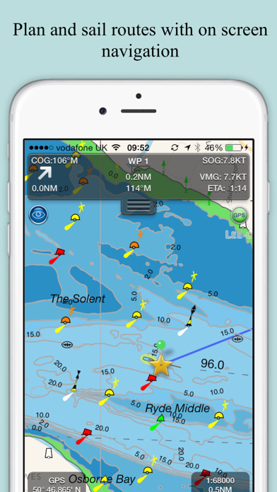
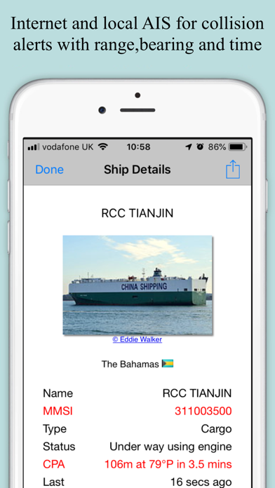
In-app tools let you measure distances and bearings and record waypoints on routes to sail. When you are out at sea, the app’s Sailing HUD shows your position on the route, Course over ground (COG), Speed over ground (SOG), Vector Made Good (VMG), Estimated Time of Arrival (ETA), Distance and bearing to next Waypoint. Waypoint reached alerts, auto-routing to the next waypoint and flashing collision alerts (with Boat Beacon).
SeaNav has a free Pebble app available for those with thee Pebble Smartwatch. Lowrance, Simrad and B&G GoFree support is also included.
Our unique AR view mode (optional IAP) allows you to view buoys, lights, ships, waypoints and track overlaid on your iPhone or iPad live camera view. With "AR LockOn" you can select a target on the chart and then be guided to it in the AR camera view.
Requirements:
iPhone or iPad. GPS only required for real time route navigation. Optional Real time AIS, Tides and Weather information require an active internet connection.
Real-time route navigation requires a GPS location. iPhone devices and iPads with a cellular modem already have a built-in GPS, even if they do not have an active service plan.
If you have a WiFi-only iPad or iPod you will need an external GPS receiver to enable navigation. Inexpensive 3rd Party units are available to add these accurate location capabilities to your device via bluetooth.
Please note that continued use of GPS running in the background can dramatically decrease battery life.
Subscriptions
Our in-app purchases are 1 year subscriptions, which automatically renew at the end of the subscription period unless auto-renew is turned off at least 24-hours before the end of the current period. Payment will be charged to your iTunes Account at confirmation of purchase, and will be charged for renewal within 24-hours prior to the end of the current period. Pricing for our 1 year US Charts update subscription is $19.99.
Subscriptions may be managed by the iTunes account holder and auto-renewal may be turned off by going to Account Settings after purchase.
No cancellation of the current subscription is allowed during active subscription period.
Our Privacy Policy may be accessed via http://seanav.net/privacy.php
Reviews
Very Limited Demo
Geo_
This is, apparently, nothing more than an advertisement or a very limited demo. Where are all the features? The app doesn’t work as advertised. The only thing that works is the compass. Everything is ala carte by subscription. Based on my experience and other reviews, I don’t trust the developer enough to fork out big bucks for subscriptions.
Intuitive and accurate
Flip Flop Navy
I have had SeaNav for a year now and have learned to trust it. It is just as accurate as any high dollar system and is easy to use.
Excellent program
Simeoniii
Had this installed for a while and I’m now beginning to use it. Integrates well with my Wind Instrument. The building of routes and importing waypoints stumped me but after reading the Help document. After working with the app and companion app Boat Beacon, I am really impressed. Excellent response from help desk/support and they want user feedback to guide their future app updates. I am changing my rating from 4 to 5 stars.
I’m pay 29.99$ can’t do anything never manage a new route then I have to buy more and more ??
??The lady
Feel unhappy with this ??❇️
Sailing mode crash
Fongzulu0
Cannot start sailing mode to test all functions supporting apple watch (period)
By far, the best sail nav app available
iPhoneGuy321
Of all the apps I've tried in this genre, this is the very best one and well worth the $$. The vector maps are amazing in detail, easy to read and super fast even on older iOS devices (aka iPhone 4). Great in--route tracking and tracing. Amazing HUD. Fabulous for nighttime navigation. Active captain integration is terrific as well. My only wishes would we course integration with nmea 2000 devices (autopilot, etc). as well as easy export import of route plans between iOS devices.
Great for this newbie
Mazeppa
I am a novice boat renter. This app really helped me stay on course in unfamiliar waters.