Scenic Map Grand Canyon
| Category | Price | Seller | Device |
|---|---|---|---|
| Navigation | Free | Mark Granger | iPhone, iPad, iPod |
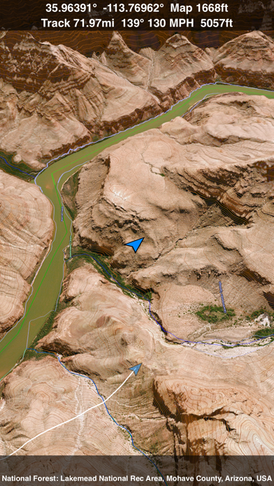

Online satellite image overlays add breathtaking detail and realism to the maps (tap preset 2 or 4 when Online Map is enabled). You can use them as you travel to see what is hidden from view at ground level. This takes moving maps to a whole new level. With an in-app purchase you can expand the coverage to the entire world via the Scenic Map online map and cache the data for offline use.
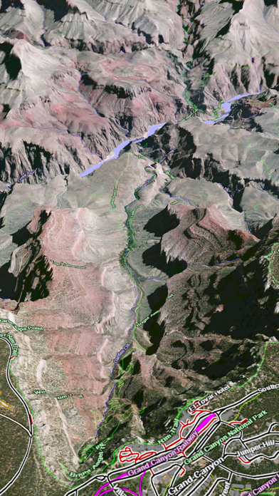
Use the two finger vertical swipe gesture to tilt the map for a 3D view. Scroll like a map or fly like a flight simulator. Enable Joystick Gestures in the Settings menu and then fly around the terrain using a virtual joystick. Prefer only 2D maps? Enable the 2D Map option in the Settings menu.
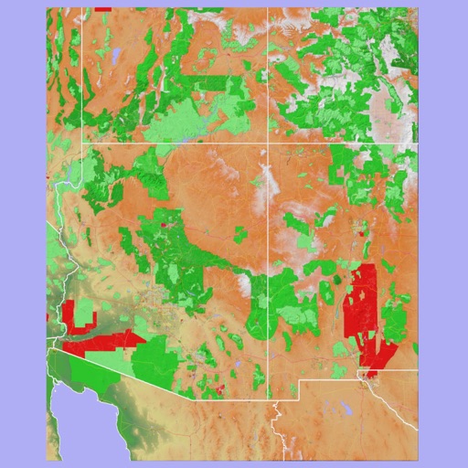
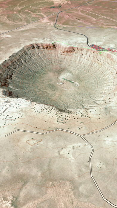
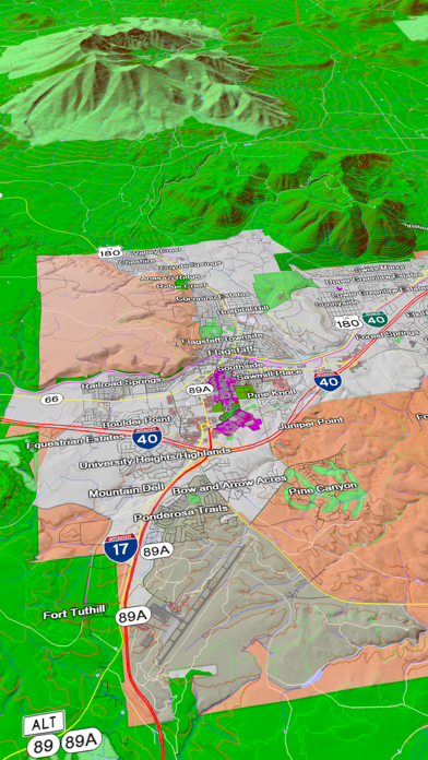
Scenic Map is simply the best 3D topo map available for a mobile device. You will see incredible detail while scrolling, rotating and zooming perfectly smoothly. You will see every road even if you zoom out to the altitude of a satellite. As you zoom in, you will see every small bump and hollow of the Earth and terrain features as small as ten meters. Unlike old fashioned topo maps, Scenic Map’s roads and trails are up to date thanks to OpenStreetMap.org. It contains polygons for urban areas, shopping malls, an ever growing number of buildings and many other features, The best lake, pond, stream and rivers from the USGS and Canadian public databases are also included.
Tap the GPS center button to begin tracking your location. As you move, you will generate a track file. Tracks can be replayed with video like controls to speed up, slow down, pause, restart or skip to the end. You can display existing tracks while recording another if you want to retrace your route. When online, you can automatically create a route from your current GPS location to any other point on the map. Tracks can be received from or sent to other apps in GPX format. GPS recording stops automatically after you have remained stationary for some time or you can choose to manually stop tracking by tapping on the top track in the Tracks view.
Never before have maps been this customizable. For example, you can turn on or off the roads. You can change the lighting direction or remove terrain shading entirely. You can display contour lines even over satellite images. There are five presets which let you quickly switch between map styles. Use Metric, English or Nautical units and choose one of four different coordinate displays including UTM.
Want to learn more about a map feature? Tap the target icon and center the feature under the compass rose to display its name, type, urban area, county, state, elevation and coordinates. You will also see a bearing line back to your current GPS location or from your location to a selected waypoint. The status bar shows the bearing direction and distance along with the map and GPS elevation, the track length, and your current speed and direction of travel.
In-app documentation is provided in the Help section at the top of the Settings menu. Links are provided in the documentation to detailed coverage maps, tutorial videos, installation guide and blog at ScenicMap.com
Map data © OpenStreetMap and contributors under the Open Database License
Scenic Map supports GPS tracking while the app is in the background.
Caution: Continued use of GPS running in the background can dramatically decrease battery life.
Reviews
Huh?
Four2x4
Really not very useful. A lot of space for little benefit. Also it boasts no need for Internet, but, it would be better to use other tools for research and map use of these areas. This simply gives very little for the space it takes.. Sorry.
Sad
iPaaaad
Terrible UI, non-responsive interface... Too bad, because apps like this could be very cool. Yes, it works, but it's very poorly done.
Very cool
Seantos
I like it. Alot of attention went into the details. Unfortunatley the iPhone screen is so small it's hard to appreciate the true potential of this app. I've been to the canyon and 3g isn't an option so loading could be an issue. But all things considered, including the price (FREE), it's a nice app.
Apps like this are why I love my iPad
JangoFett9
For hikers and campers, I can't imagine how it could get better than this. It's a massive, extremely detailed map, crammed into your iPad! I suspect that whatever people were complaining about before, is long gone now. Because the whole Scenic Map series has been very responsive on my iPad. This is absolutely a game changer. It's very fast, very responsive, and has a clean, simple interface. The clutter-free UI is vital when you're carrying a heavy backpack, and you're in unfamiliar territory. The fact that it's completely self-contained makes this a million times better for actual campers than any server side app could ever be. I can take these Scenic Map apps with me, and I've got a permanent, complete map of every place I could possibly want to stop at, right there on my iPad, even if I can't get a cell phone signal (or much less find a wi-fi hotspot). Now if the idea of a hiking destination that doesn't have 3G coverage sounds uncivilized to you, this might not be the app for you. And you should probably stay inside the city limits, where it's safe. This is the first decent replacement for a map I've seen on the platform, and it works great. Very fast. Very easy. Very responsive. I have no problem recommending this to everyone. It's a no-brainer for anyone who spends any amount of time outside. And this one's free! But even for the others, even at $10 a pop, they're a hell of a lot better deal than any of the paper and plastic maps I've bought in the last ten years. Great job, GrangerFX!
Limited use
Shakazuuluu
Next time I go back there I need to have the shuttle routes and schedules serving the various lookouts, and why not also thumbnail images/video clips so people can decide whether or not to stop there or hurry to the eastern side of GRAND CANYON or perhaps get something to eat...now that's the app i'll keep
Start Here
S.Kuss
I tried out this App, and within days had purchased the full Eastern version. See my extended comments there. Get the one for where you live.
Scenic Map Grand Canyon
ccummac1
This is one of the most fantastic topo map programs I've ever used, and it is on my cellphone. If I only had this 40 years ago when I started backpacking. Roll Tide Roll!
Disappointed
RedRocks55
The maps are virtually useless: 1- the text used is far too large and does more to obstruct the view than it does to help. 2- all the text is oriented horizontally and oversized leaving you to guess at which text goes with which street. 3- The "buildings" shown on the maps are little more than sat view outlines with no reference or naming for parks, malls, etc. 4- The paid versions offer no benefit over the free maps so download the free first, If those serve your purpose, you may be ok with the substantially overpriced paid versions of this app. DISAPPOINTED
El Crapola
TD's Cox ID
Worthless as it stands with bad maps in limited areas with poor lettering and lousy graphics and repeated ad-cluttered pitches to upgrade, What's not to like??? Sometimes I think app developers are geniuses and sometimes, like these guys, are just either incompetent or con artists. Don't even give them the dignity if your click on. Sorry I did.
Better than trying to fold those gas station maps back up to fit in the glove compartment
The OnionEaters
To answer Mark's question, it's 256Mb. Suggest you check your internet connection. Took me about 3 minutes to download and 1 minute to install. After playing with this for a while I'm sure there is more here than most people would ever use. Even on a trip to the Grand Canyon this would give you enough info to make your trip way more enjoyable. All the places that people never get to. Hell, I'm going this spring. See ya there.