Rome Metro & Tram by Zuti
| Category | Price | Seller | Device |
|---|---|---|---|
| Travel | Free | Visual IT Ltd | iPhone, iPad, iPod |

● Simple, fast and easy to use.
● Designed for the first time visitor and experienced commuter.
● Unique "Travel Explorer" feature provides a view of travel times and distances from any location on the map.
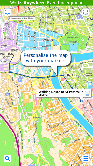
● Professionally drawn colourful and clear map with geographical features and places of interest.
● Planned route animates on the map.
● Saves and recalls favourite and recent journeys.
● Take me home feature.
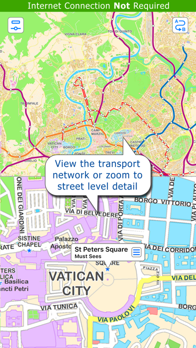
● Online street map integration (when an internet connection is available).
● Services can be turned on or off, routing around problems.
● Works in both landscape and portrait modes.
● Easily locates your nearest transport stop.
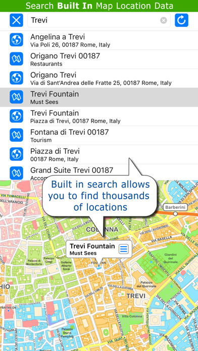
● Places of interest, parks etc are built in to the application.
● OVERVIEW ● The Rome Metro - Map and route planner by Zuti makes it easy to travel in and around Rome using the Metro, Trams and Urban rail networks. The application contains a professionally drawn map and route planner with many unique features. The inbuilt map provides a simple and colourful view of the city transport services with the ability to flip to an online street map view when an internet connection is available. This way the user can view the online map feature when above ground and the transport map and route planning is still fully functional underground or anywhere there is no internet connectivity. This provides the best of both worlds, the transport map and route planning anytime, anywhere and online street maps and search when a connection is available.
● TRAVEL EXPLORER ● The unique travel explorer feature provides a view of travel times using transport and on foot and distances from any location on the map. This is helpful for getting a sense of scale and connectivity of the transport system and can provide some interesting results. For example is it quicker to use the metro and tram to travel from Colosseo to Argentina or is it quicker on foot? (Hint, the quickest route will keep you fitter). No other application makes it so easy to get around on the transport systems and allow you to make travel decisions based on the actual distances and travel times on foot.
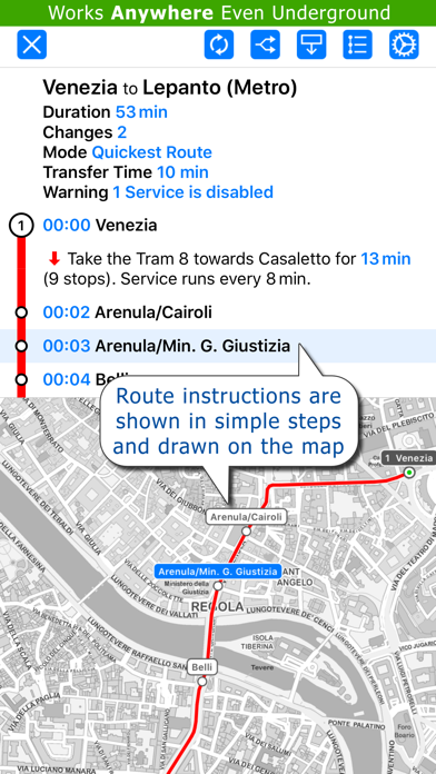
● ROUTING ● Does not require an internet connection and will always be available to display a clear and detailed view of the city transport system, plus list and animate the optimum route for your journey. Provides the fastest route calculations of any mobile routing application (virtually instantaneous) using actual published journey times with the ability to select the quickest route or the route with the least changes.
Comprehensive details of your planned route are provided, including “direction”, “towards” and “service frequency” information (not available on any other offline journey planner) for example “Take the Metro B (Northbound) towards Rebibbia for 4 mins (2 stops). Service runs every 10 minutes” which is essential when finding the correct platform and direction. Also given are alternatives (if available) for each leg of the journey.
● NO INTERNET CONNECTION REQUIRED ● The map and routing do not require an internet connection and you will not be charged data connection fees. This also means the application runs perfectly underground, on an aeroplane, etc. For international visitors to a city who have data roaming turned off this is an ideal solution.
● MORE MAPS ● This map is one in a series of Zuti worldwide city maps, if you like this product you may also enjoy some of our other offerings, please visit www.zuti.co.uk for further information.
Reviews
Very useful app! Must-have when in Rome!
Applepious
I've used this app every day while on vacation in Rome in Dec 2013, and I want to share with others how awesome it is, because I have found it so useful: 1) It tells you the quickest way between 2 stations, and tells you the route you should take and how long it will take. 2) It includes maps of the subway, tram lines, and rail lines. Some of the tram info is a bit outdated (developers, take note!!!) It would be perfect if bus lines were included as well, or at least a listing of all buses and where they stop (developers, also take note!!!). 3) My favorite feature: it includes a GPS, and will track where you are on your route, which is so useful on trams, because the stops are not announced! 4) Also the GPS feature will tell you the tram/Metro station nearest to where you are, in case you are lost in Rome. I would highly recommend downloading this app if you are planning on staying in Rome for more than a few days. It's been so helpful, I wish this was available for other cities!