Pilots Atlas
| Category | Price | Seller | Device |
|---|---|---|---|
| Travel | Free | absolutezero multimedia GmbH | iPhone, iPad, iPod |


Overview
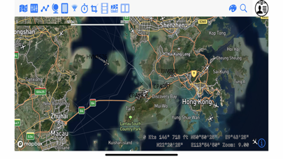
Detailed mapping with selectable aeronautical overlays.
Create your charts with the information you choose. Add positions, notes, photos and share with friends and colleagues.
Now increased functionality and Global coverage to offer you an enhanced solution with just the right mix of land and sky with custom tailored charts and information.
Create your own map style with 5-8 different background maps / 15 different map layers and 21 different databases (aeronautical/ navigation-aids and Points of Interest´s etc.). Insert, store and/ or edit your flight planed route by using ICAO/ IATA-codes, waypoints, VOR´s NDB´s or Lat/ Long. Find positions with a separate Lat/ Long finder.
Insert and save your destination favorites, create trips, waypoints, photos or notes directly on the map. Implement screen shots from your online-map into the offline-map.
- Contour level by color (meter + feet).
- 120,000 Waypoints (three different types)
- 22,000 Airports (three different types)
- 75,000 Nav-aid´s (VOR-DME, NDB, TACAN, VORTAC, ILS-DME)
- 10,000 POI´s ( points of interest)
- FIR Boundaries
- Special Use Airspace areas (SUAs)
- topographical maps
- Trip planning (by Waypoints, VOR´s, airports, NDB´s, ICAO/ IATA codes or Lat/ Long).
- Share, copy, invert or export your trip, delete/ edit single trip-points or whole trips. The whole triplength is shown and also the distance between single trip-points.
- Show all your trips (or select your specials) in the map by different colors.
- 8 different charts on board: planning chart, offline map and online maps (OSM), OnlineMapQuest, Open Aerial, NASA Satellite today, NASA Satellite yesterday and NASA City Lights.
- Airports, Runway length, elevation, ICAO/ IATA, airport-name, city-name, Lat/ Long, frequencies, magnetic variation and much more
- Create range-circles around airports
- METAR + TAF are available by clicking on the airport-icon and you can create/edit your own weather-list (along your trip/route).
- connect an external GPS
- delete and re-download the areas you need whenever you like.
Captains Corner reference stuff:
- Aviation Converter / Calculator: (temp., mass, area, volume, energy, speed power, pressure, length, force..)
- Weather symbols
- Turbulence
- VOLMET table
- SNOWTAM decoder (Notam + Metar)
- MEATAR decoder
- Aircraft country table (Capital city, reg.-code, ISO-code, dialing-prefix, time zone)
- ICAO prefix table
- Thumb rules
- Volcano warning
- Aeronautical abbreviations
- Morse codes
- Airport category
- Operating minima
- Operating minima CAT I + II
- Climb rate
- Jet fuel calculator
- Airport directory
- Nav-aid directory
- Waypoint directory
- Points of interest (POI) directory
- TAF decoder
- IATA delay codes
- Dangerous goods
- Military Interception signalling
- Military MEATAR color codes
- ACARS frequencies
- Airline ICAO-codes
- Flag Gallery worldwide
- Wind chill calculator
Additional weather-overlay as an InApp- subscription: 1-month free trial, (services provided during each subscription period).
The Weather-Layer is an yearly auto renewing in-App- Subscription for 3.99 USD with 30 days free trial.
Payment will be charged to iTunes Account at confirmation of purchase.
Subscription automatically renews unless auto-renew is turned off at least 24-hours before the end of the current period.
Account will be charged for renewal within 24-hours prior to the end of the current period, and identify the cost of the renewal.
Subscriptions may be managed by the user and auto-renewal may be turned off by going to the user's Account Settings after purchase.
Continued use of GPS running in the background can dramatically decrease battery life.
privacy policy: https://www.absolutezero.de/privacy/index.html
terms of use: https://www.absolutezero.de/index.php/terms-of-use-2
Reviews
Captain Bbbot
All used
Used to love this app Used it all the time With the latest updates It is almost worthless to me Sorry but I don’t like anymore
Needs improvement
aaircrew.com
Having used the excellent paper version of Pilots Atlas in the past, I must admit that I'm somewhat disappointed with the app version. As an airline pilot flying long haul on the B744, I enjoy bing able to identify landmarks and other items of interest when flying over them as the maps we use on the aircraft are not designed to show ground features. I have just tried out the app on a flight from London to San Francisco and I found it extremely frustrating to use the app on my iPad mini which accompanies me on all trips. The number one complaint being the text size on the map, especially when zooming in, remains miniscule and almost impossible to read for an old codger like me. Whilst I understand that the app is aimed at all levels of pilot, for me, it was disappointing because I could not read the text on the map and by the time I had managed to do so the location was far behind me and not visible anymore. Also, when entering a route, it does not plot the course as a great circle but rather as a rhumb line which is not strictly useable as a guide. Trying to construct a long haul route using the waypoints as published on our flight plans and in our Flight Management Computer (FMC) database is impossible. For example, when flying over some of the great Canadian wastes, there are some landmarks that we want to identify but our position is only referenced by lat/long. The method of entering the lat long in the app is cumbersome using the spinning wheels. It would be much better to just enter coordinates in NSEW which we can take directly from the FMC. Also, if the waypoint is only a lat/long reference, there seems to be no way to actually enter it as a temporary waypoint in the route. The route only accepts waypoints already in the database. For example, if one of our waypoints is N60 W070, we can enter that simply as 6070N and that is an accessible waypoint. There's no published waypoint in the database or any nav aid but it is still a waypoint that should be able to be referenced in a map application. On a paper map, I'd be able to find that point and mark it if necessary. Anyway, the app has the potential to be very good for all pilots who have an interest about the terrain they're flying over. The number one concern is to have the text on the map scale up as one zooms in so that you are not left squinting or searching for a magnifying glass to read the map. Enhancing the way locations can be entered as lat/long is also desirable. Being able to save those manually entered waypoints would be even better. So, overall, nice try but room for improvement.
Captain Bbbot
All used
Great first shot at the iPad app! Love it almost as much as the AbsoluteZero Paper Atlas that I have used for almost ten years. Already have found it very useful on flights. (I fly for an airline around Asia and have occasional trips to North America.) A few little items would be helpful to change. 1. Organize User Trips. The ability to organize this would be helpful. (i.e.. alphabetical or by icao/IATA groupings.) 2. Establish User Waypoints. A way to establish your own waypoints (by lat/long, bearing/distance, or touch screen), then label it, and use it within a trip. 3. An Operations Manual on how things operate within the system. I have found my way through most of the items within the app. However, a manual that gives you limits of trip inputs (total trips available and also waypoints within a single trip.) I originally downloaded the app. Then I bought the Asia charts to see how this all works. I WAS SO HAPPY with the app, a week later I decided to buy the Whole World charts. I am waiting to see if I can get an adjustment to this. (This would be appreciated by many, I am sure.) Looking forward to the evolution of this app. Thanks. BBBOT
Average
Stunnedmullet
This App has Great potential. Be aware though that it does not include airways which is surprising. Also until zoom is used enroute waypoints do not appear. Building user routes from flight plans is a tedious time consuming affair. User friendliness needs to be addressed.
Mr.
MD-80 Caribbean.
This app doesn't have all airports. Even big international airports are missing, which is a pity. So unfortunately I'm not able to use it.
Don't Waste Your Money!
WayneShannon
This app is completely useless to airline pilots. besides the fact that the planning function does not include an airway database and therefore will not accept airline routes, all the information in here is geared toward basic flying. Other applications such as Foreflight are well ahead of this one and at a fraction of the price.
Could do with major improvement
Gerxt
Zoom level need to be closer, nowhere near enough detail. Few names for cities and features. Missing lots of small island names. Perth Australia is not in Southern China. Must have facility to bring up or at least plan via airways. Font is too small, should have a option to increase font size. Way too expensive for what you get. It's one thing charging $28 usd for a book, but an iPad version should only be $10 max. Not worth it for the money. Has great potential if European pricing level reduced to a reasonable level and the above issues are addressed.
Poor implementation
WingsThree
The basic mapping feature is useless, unable to zoom in offline to anything usable. Purchased the North America detailed "HD" map, and will not install properly - so far a waste of $28. Don't spend money on anything until the developer repairs the problem.
Metric elevations and few mountains. Bummer.
Hillenbrand
There are few landmark mountains listed and those that are are in meters. Other than that the rivers and roads are labeled nicely and there are nice shortcut math features and calculators. Standard elevations and more landmarks would be nice in offline map.