OvitalMap
| Category | Price | Seller | Device |
|---|---|---|---|
| Navigation | Free | Beijing Ovital Software Co.,Ltd. | iPhone, iPad, iPod |


OvitalMap has the following features:
1、 Support a variety of well-known maps
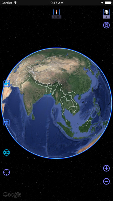
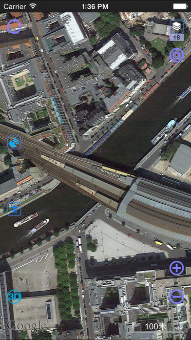
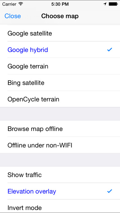
At present it supports Google map, Google satellite map and Google terrain map. The user can easily switch between these maps. The maps can be downloaded for offline applications to save 3G traffic.
2、 Route search
Google API offers a search engine to choose the best route for you. It will find an optimum solution for your travel, either by walk,bus or driving.
3、 Interactive voice navigation
There will be voice navigation for the walk or driving route suggested by the system. The location of friends will be shown on the map dynamically so that you can know where they are and don’t need to worry losing their positions any more. The system can highlight moving tracks of more than one friend with lines of different colors.
4、 Information search
The API search engine will offer information about your location, roads, and buses, as well as hotels, entertainment, banks, restaurants, supermarkets, gas stations, parking lots, and tourist attractions nearby a certain position. Catering and entertainment providers can also be sorted by price or customer ranking.
5、 Location sharing
You can share your location at a certain moment with selected relatives or friends so that they will know your position on the map.
6、 Communication with friends
When you are using the system to chat with a friend (just like using QQ or MSN), you can insert a location tag, travel solution, or a map created by yourself. After receiving the insertmessage, he can have it shown on his map by a simple click. Thus, if you know the position of your friend, you can draw a route on the map and send it to him. The route will be shown on his map for him to follow.
7、 Track record
The system can record your tracks, which can be saved and sent to friends.
8. Elevation data service, the Cloud of Ovitalmap integrate SRTM3 elevation data around the world. You can quickly see about any place’s altitude in the world. We also can direct output the contour line in 10 meters on the satellite map, which helps you directly see the elevation data on satellite map.
9. Real 3D map, which is similar to Google Earth, combines the satellite map and elevation data, and can show the real terrain of the world.
-----------------------------------------------------------
Continued use of GPS running in the background can dramatically decrease battery life.
Reviews
Privacy Concern
monsterhighgirlthegreat
App requested the Microphone and Camera permissions. I don't see the benefit of having this app access my camera whenever it wants. App would not let me access anything unless I accepted their requested permissions. I believe this app is suspicious and is manufacturing various pretextual allegations in order to secretly sell your data for a lot of money that unfortunately you wont see. Unless this app sends me a check for 10% of my datas profit then I wont use it. Thank you
.gpx file sharing
sj54689:4)$3:
Previously it was possible to import .gpx files from other applications into Ovitalmap, but in iOS13 it's impossible. Latest update of OM doesn't solve this.
Great images, nice features!
Shangrila-1084
We’re on a sail boat exploring Indonesia. Satellite images are extremely helpful, especially to have them available offline. Great App, Thank you!!!
Great while the images remain but they will disappear
travelinda
After spending many hours scanning a number of areas to be used to help with navigation I later came back to find that more than 50% of the saved images were removed. There is no decent documentation to help one figure out all the options. It would be a 5 star app if there was a way to keep all the images from being removed. Frustrating there is no documentation in English to help with setup
It's really good map! Recommend it to everyone!
Apple should review this app
It's really good map! Recommend it to everyone!