OFFROAD ATLAS
| Category | Price | Seller | Device |
|---|---|---|---|
| Navigation | $0.99 | Michael Keiser | iPhone, iPad, iPod |


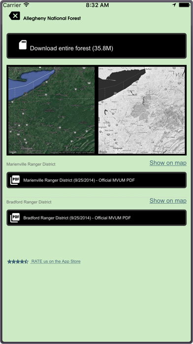


What is a MVUM? It is a map that shows where you can legally operate a motor vehicle on National Forest land. OFFROAD ATLAS uses your phone’s GPS to show your location on our seamless map. We combine the MVUM with other data such as local roads and our map is easily downloaded for offline use.
You may browse the map while you have wifi or cell service and OFFROAD ATLAS will automatically download any of the areas you view for offline use when you don't have network access. You may also bulk download any of the areas you plan on visiting.
Always have as much information as possible, please consult the published (printable) PDF Motor Vehicle Use Maps available for any individual forests you plan on visiting to get the latest dispersed camping allowances, seasonal closures, and any other relevant information. As always, be careful, many trails and roads are not suitable for passenger car travel. Some are only traversable in the most capable off road vehicles by the most experienced drivers.
Have fun, be safe, and respect the trails.
OFFROAD ATLAS makes no warranty, expressed or implied, including the warranties of merchantability and fitness for a particular purpose, nor assumes any legal liability or responsibility for the accuracy, reliability, completeness or utility of these geospatial data, or for the improper or incorrect use of these geospatial data. These geospatial data and related maps or graphics are not legal documents and are not intended to be used as such. The data and maps may not be used to determine title, ownership, legal descriptions or boundaries, legal jurisdiction, or restrictions that may be in place on either public or private land. Natural hazards may or may not be depicted on the data and maps, and land users should exercise due caution. The data are dynamic and may change over time. The user is responsible to verify the limitations of the geospatial data and to use the data accordingly.
The OFFROAD ATLAS map service depicts Forest Service roads and trails that are designated for motor vehicle use under the official U.S. Government Code of Federal Regulations for identifying designated roads and trails (36 CFR 212.56). Road and Trail MVUM. Additional roads, such as highways, county roads or public roads, are included for mapping purposes. This map service shows the specific types of motorized vehicles allowed on the designated routes and seasonal designation. Data used in this map service are designed to be consistent with the MVUM (Motor Vehicle Use Map). The road and trail data are compiled from the GIS Data Dictionary data and Infra tabular data that the U.S. Forest Service administrative units have prepared for the creation of their MVUMs. This data is published and refreshed on a unit by unit basis as needed and approved by the individual units in order to stay in sync and consistent with the published MVUMs. Interstate, Highway, Other Major Non USFS Roads, and Historic roads for reference are for mapping purposes only and should not be relied upon for their availability for motorized use.
U.S. Geological Survey National Hydrography Dataset, U.S. Department of Transportation Federal Highway Administration HPMS, and various USDA Forest Service datasets used in compiling this information.
Reviews
Incredible!
4x4Explorer
Not sure what issue 450ex had, but it is awesome to finally have easy access to all the MVUMs. Found many new trails this weekend.
Off road atlas review
Lab lady M
This is a useful app in exploring the trails in the parks and forests- much better than the paper maps given by the rangers
Don't leave home without it
robot.Jill
Knowledge is power- have more fun knowing where you're going and remembering where you've been. This is a great app. Get it, use it, love it. And if you don't love it, the developer is very responsive with troubleshooting issues.
Great App for serious off-roading and outstanding customer service.
Learo2000GT
First off. Those giving bad reviews most likely didn't read what the app is intended for and the areas that is covers. I live in Washington state and all of the national forest are available. Furthermore, I had a few questions and Mike went out of his way to help me with making the most of the app. This app ensures that I tread lightly, plan accordingly and stay on roads that I can legally travel.
All around good
kikinit86
Great app covers Michigan well, I would like to help the developer update it though cause there are some trails that have closed in my area, I feel like the app could have more goin for it if u cud track your movements through the trails and then share it with other users, and be able to add certain trail information like if there's rocks or obstacles to look for, all in all not a bad app
Works good WITH cell service
Jeepsandjets
Says you can down load maps for use with out cell service but Map Cache said "download maps will not work till you regain cell service" If that true what good is it back in the mountains with no cell service
Impossible!
Cakid88
This app appears to be designed by a beginner app designer. It is very unusable, and inaccurate. I can't believe I actually paid for it ?! I don't think the app designer has any interest in improving it, it's been over a year since the last update.