NaviMaps: 3D GPS Navigation
| Category | Price | Seller | Device |
|---|---|---|---|
| Navigation | Free | C E Info Systems Private Limited | iPhone, iPad, iPod |
NaviMaps: 3D GPS Navigation, an interactive maps and navigation app with voice direction. Get detailed maps of India, Bangladesh, Bhutan, Nepal & Sri Lanka, powered by MapmyIndia. Save your mobile data as NaviMaps: 3D GPS Navigation doesn't require internet to function. With internet, get Live Traffic feed, Location & Route sharing via SMS, WhatsApp, Viber, Email & Facebook.
INSTALL NaviMaps: 3D GPS Navigation today to get access to all Pro-Guidance features for FREE for 7 Days.
Features Include:-
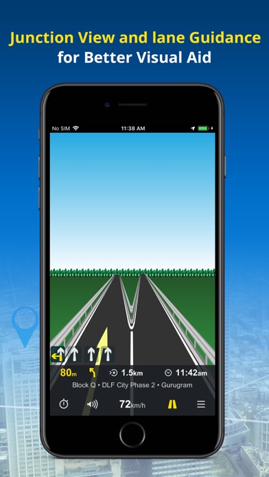
• Junction Views - Visual aid to the driver at road junctions.
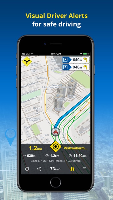
• Driver Alerts & Realistic Signposts - Visual driver alerts for better situational awareness.
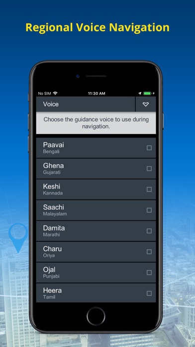
• Live Turn-by-Turn voice guidance in English & 10 regional languages: Hindi, Kannada, Marathi, Punjabi, Bengali, Gujarati, Malayalam, Oriya, Tamil & Telugu*
• Text to Speech - NaviMaps speaks out place names during voice prompts.
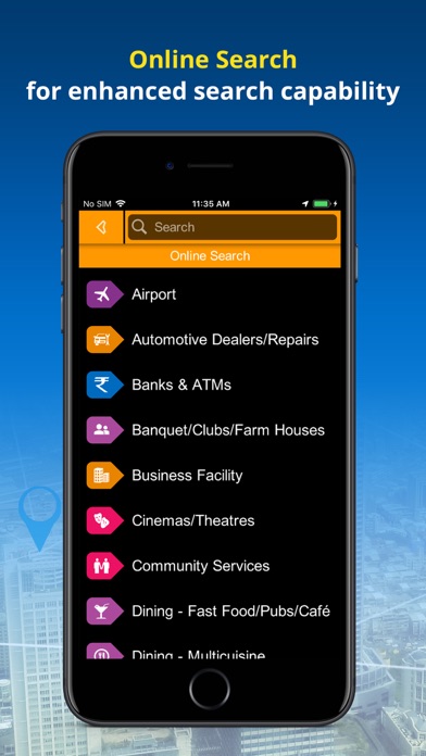
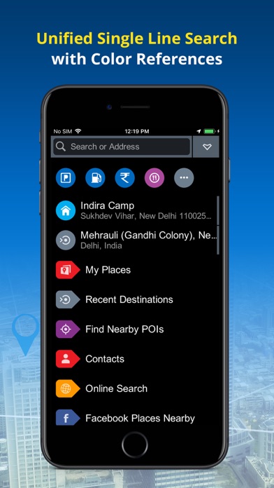
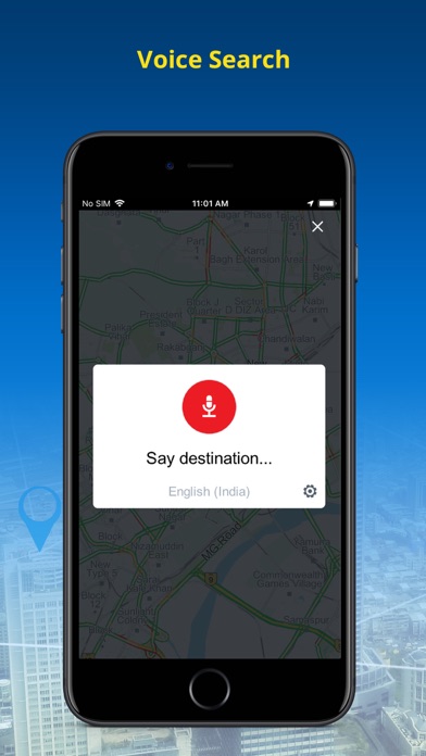
• Unified Search: Search EVERYTHING from one interface with colour coded visual references.
• Auto re-route navigation with voice will re-route you from the deviated course.*
• Varied POI, down to the house no., also locate Petrol Pumps & Parking Places along the route.*
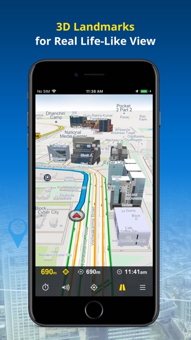
• Detailed map coverage, realistic 3D Landmark, terrain & city models for better recognition*
• FREE lifetime MAP UPDATES*
• NaviMaps: 3D GPS Navigation can be synced with your in-car navigation system, making it into a fully featured navigation system. NaviMaps supports connectivity with TATA motors, Pioneer AppRadio compatible devices*, ConnectNext Infotainment system and Jaguar Land Rover InControl™ Apps compatible vehicles*
• Offline maps, directions & local search on your device
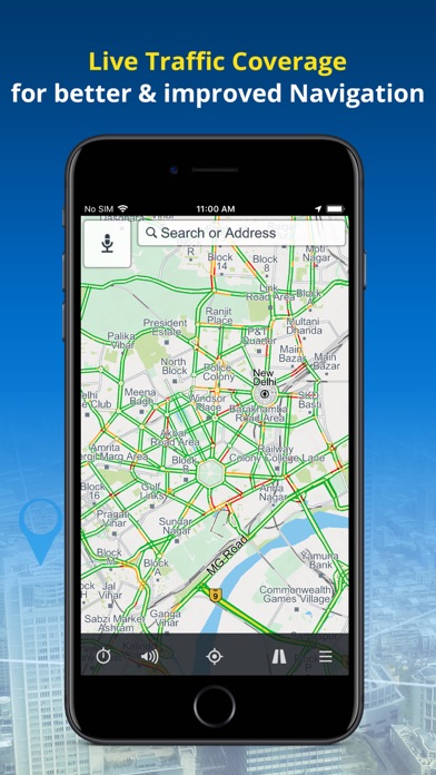
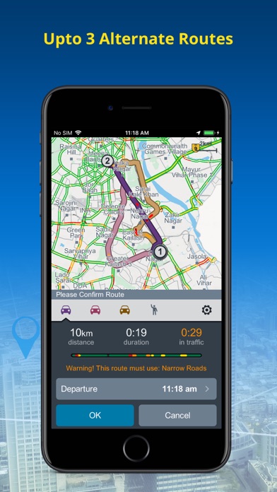
• Get up to 3 alternate driving routes & 1 pedestrian route. The route automatically updates you with Live Traffic (Internet required)
• Location & route sharing through WhatsApp, SMS, Viber, Email & Facebook
• Via internet, get live traffic & expected delay.
• Multi-Stop routing to plan trips for leisure or business
• Multi-touch map display
• Two-finger swipe down to return to map view from any page or menu
Maps:-
Map of India is split into 32 different states which you can download as per travel plan. Download, remove & re-download maps as often as they like.
NaviMaps is powered by MapmyIndia allowing you access to:-
• 5.44 Mn+ kms of roads connecting 7266+ towns & 6.5+ lakh villages
• 25.41 million+ points of interest across the country
• 6767+ 3D Landmarks & 2D footprints in 254 cities
• 11.48 million+ house numbers for last mile navigation in 338 cities
• Lane Guidance in 597 cities along with national stretches
Sri Lanka:
• 109000+ kms of roads connecting 265 cities at street level with 427 towns & villages
• 125600+ Points of Interest
• 94 3D Landmarks & 527000+ 2D footprints in 27 cities
• Lane Guidance in 5 cities
Nepal:
• 150000+ kms of roads connecting 221 Cities at street level with 6460 towns & villages
• 65000+ Points of Interest
Bangladesh:
• 102000+ kms of roads connecting 107 Cities at street level with 1957 towns & villages
• 107500+ Points of Interest
• 860000+ 2D footprints
Bhutan:
• 9600+ kms of roads connecting 27 Cities at street level with 113 towns & villages
• 2200+ Points of Interest
LIVE TRAFFIC Updates for the 47 cities.
Install NaviMaps: 3D GPS Navigation today.
Note:
Continued use of ANY GPS application running in the background can significantly drain your phone’s battery. Using a charger while navigating is recommended.
* Requires purchase of Pro-Guidance in-app.
For any app related issues and feedback, please mail us on ([email protected]). We would love to hear from you.