Natural Atlas
| Category | Price | Seller | Device |
|---|---|---|---|
| Navigation | Free | Natural Atlas, Inc. | iPhone, iPad, iPod |

A free Natural Atlas account is required to use the app. Recordings sync to your online profile & private recordings are available via an in-app upgrade.
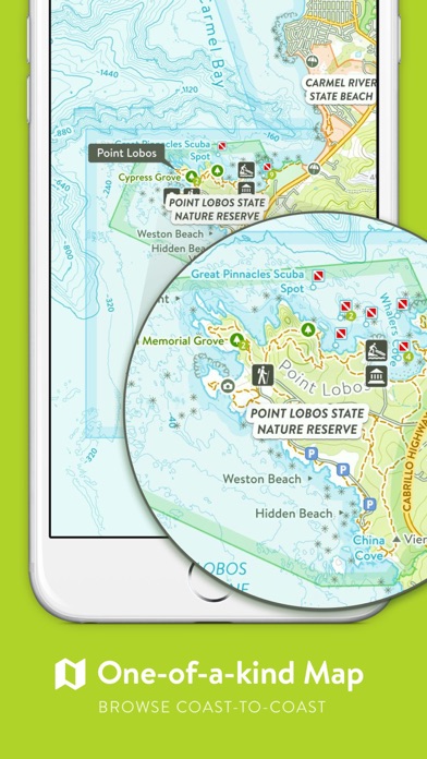
■ THE MAP
The Natural Atlas Topo is a one-of-a-kind map of the United States outdoors you won’t find anywhere else on the App Store. It’s continually evolving and will improve with your use. It’s especially-polished in the Western USA. Browse online for free: https://naturalatlas.com
■ FEATURES
– Powerful, yet simple
– Works Offline
– 100+ Color-Coded Activities
– Switch Activities while Recording (e.g. Driving to Boating to Hiking)
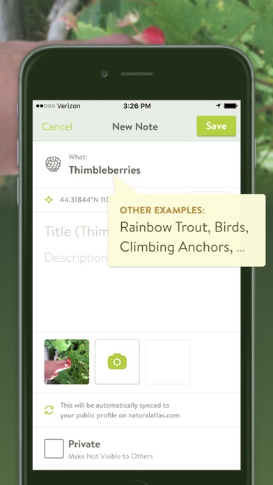
– Stay Organized with 45,000+ Note Presets (Wildlife Species, Plants, Rocks & Minerals, and more)
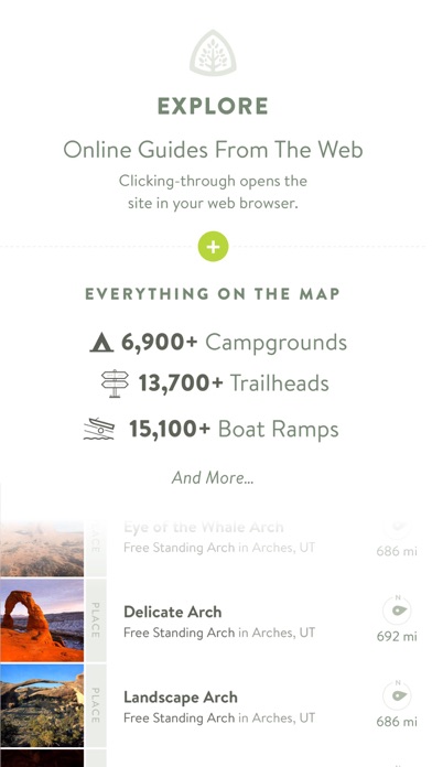
– Browse 1000’s of Campgrounds, Boat Launches, Waterfalls, Hot Springs, Arches, and more (search everything on the map)
– Advanced Search: “SF Hikes”, “Giant Sequoias in Yosemite”, “Boat Ramps on Yellowstone River”, “Oregon Beach Accesses” (internet required)
– Take Geo-Tagged Photos
– Speed, Distance, and Elevation Stats
– Star Places as “Been To”, “Want To Go To”, or “Like” – Keep a to-do list of places you want to visit
– Follow Friends and members of the community to keep tabs on their outdoor adventures
– Note Segments: highlight difficult climbing pitches, animal tracks you’re following, etc
– Explore Thousands of Guides from high-quality publishers on the web. Find the right guide, then click through to their website (opens in your web browser)
– Import GPX Files on NaturalAtlas.com
And more…
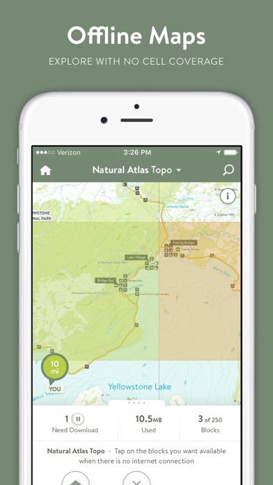
■ OFFLINE MAPS
– Simply tap the blocks (≈10x10mi) you want available offline
– Use 3 offline blocks at any given time for free (enough for most day hikes)
– Upgrade for 250 Blocks (download entire regions)
■ CLOUD SYNC
Your recorded trips and notes (markers) automatically sync to your Natural Atlas account, available online at NaturalAtlas.com. Review & share your trips online with friends, family, and the Natural Atlas community
■ PRO SUBSCRIPTION
Upgrade to Natural Atlas Pro (billed yearly) to get more advanced tools for planning your next adventure:
– Map Printing (PDFs) on NaturalAtlas.com
– 250 Offline Storage Blocks
– Natural Atlas US Public Lands Map (based off BLM SMA data) – Shows FS (including inholdings), BLM, NPS, BIA, Bureau of Reclamation, State, and Private - Designed for the Western USA
– Sunrise, Sunset, Golden Hour Times, Moon Illumination Info
– Private Notes & Trips: Want to note a fishing hole but not publicize it? Mark it as private to make it for your eyes only
– Download GPX Files Online
You can subscribe & pay through your iTunes account. Manage your subscription via the main Settings app: http://support.apple.com/kb/ht4098
Subscriptions auto-renew unless turned off at least 24hrs before the end of the current period. Your iTunes account will be charged for renewal within 24hrs prior to the end of the current period, and identify the cost of the renewal
■ SUPPORT
[email protected]
■ DISCLAIMERS
[Map Coverage] The Natural Atlas Map is United States only (excluding Alaska). The app works fine outside this area, but will show a third-party OpenStreetMap-based map (not available offline)
[Battery Life] We do everything we can to make the app low power when recording, but GPS is notorious for reducing battery life
[Sensitive Places] Notes of certain sensitive topics like petroglyphs are private by default whether you’ve upgraded to Pro or not
Terms: https://naturalatlas.com/terms
Privacy Policy: https://naturalatlas.com/privacy
■ ABOUT US
Built in the Greater Yellowstone Area of WY & MT, Natural Atlas aims to be the premier outdoor map & platform for the US outdoors
Reviews
AMAZING!!
Maytao303
State of Colorado uses your maps and it’s absolutely the BEST outdoor map I’ve ever came across! Easy to read! Now only if you can get other states aboard for there trails and camp sites would be AMAZING
Once the best. Now neglected.
Schnautz07
When I first started using Natural Atlas, I was confident that I had found the best app for recording my hikes. It didn’t have all the trails I sought, but the developers were very responsive and mapped new trails within a few weeks of someone recording them. Then, all of a sudden, their base maps stopped working. The developers said they were aware of the issue, and would be releasing an update to fix it soon. That was 2.5 years ago. It’s been 3 years since this app has been updated, and it’s quickly falling from favor in my books. Maps that don’t load, and the lack of development are sure to be the nail in this once-great app.
Has potential
Kliffyyyy
The ocean topography map is awesome, however it feels the features are quite limited. Would be cool if we could input our own gps coordinates rather than only taking what the phone reads or even measuring distances, etc
Just get it already
gdvjgtu
I don’t write reviews ever but this is the best app I’ve ever owned and it felt unfair to not give the developers credit, I don’t use it for the typical hike,bike,camping aspects of the app that they portray. If you are a fisherman get it. I track all of my floats, wades and trips. It shows elevation changes, average speed, miles etc. and you can add notes for each trip, best app Ive ever owned and I won’t go on a trip even if it’s just to a small creek to wade without it.
Awesome
blaskoa
By far the best I have used many others. Looks like orb hasn’t had any updates for two years so hopefully there is support. I got the paid version if no support I guess I wouldn’t renew. But as of now it’s the best
No support for iPhoneX or newer
StanJose
Natural Atlas has the best maps, hands down. They are beautiful to look at and the easiest to read of all the various mapping apps out there. However as of the time of this review, the app hasn’t been updated in 2 years and appears letterboxed on any iPhone with a notch, losing about 20% of the available screen space. Crossing my fingers that the developer will be able to get back to this app at some point. I will happily adjust my rating if that ever happens.
Beautifully designed, easy to navigate
bradandkelly
This app is just what I have been looking for; an online map of outdoor features and trails that makes it easy to find and record my outdoor adventures (on and offline). Thank you!
Best way to discover the outdoors
jstratman
A beautiful topo map combined with amazing data quality and organization make this the best app I've yet found to discover the outdoors. Taking notes along a trip makes it easy to keep making this experience even better. I also appreciate how well thought out the UI is; it just works and allows you to focus on the core content. Well worth it for anyone who appreciates nature!
Total Scam
R. Dawkins
To do anything in the app requires you buying the $40 per year subscription. I paid for a worthless app. What a ripoff! Trash!