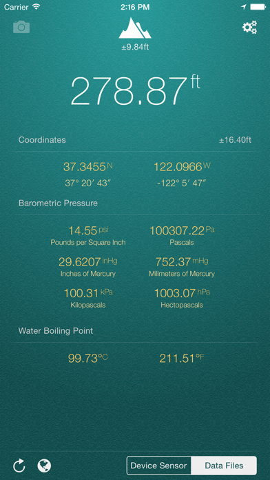
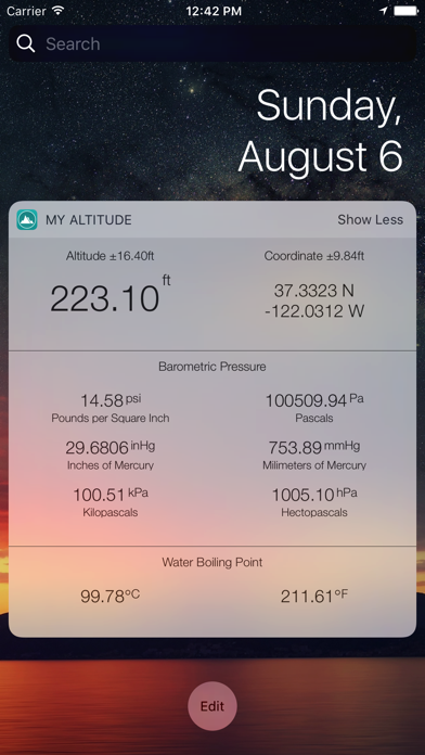
My Altitude
| Category | Price | Seller | Device |
|---|---|---|---|
| Navigation | Free | Dayana Networks Ltd | iPhone, iPad, iPod |

This application does not need an internet connection and works best in outdoors.
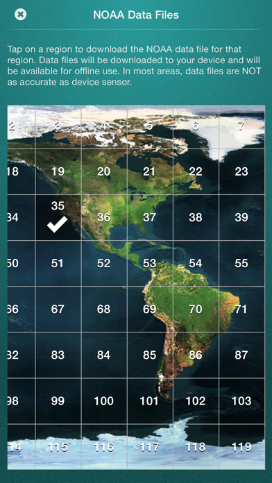
By default, it uses device sensor to determine the altitude, but you also have the option to use NOAA data files to get the altitude of your location. On newer devices, using device sensor is more accurate.
It also allows you to get a picture of where you are and save it in photo album. Picture will be sealed with coordinates of current location along with altitude and local date/time.
Barometric Pressure is calculated based on elevation. On newer devices such as iPhone 6/6+ value is being delivered directly from device built-in barometric sensor.
Enjoy.
Reviews
Super cool
Jonny the excavator
So amazing to have this on my phone. It will help with my excavation business!?
iPad need better device measurement
NCHanny
This app is constantly varying at 200 feet from the same location. In the mountains of NC this is s significant issue. The iPhone version appears to be more consistently in measurement. Both Apple devices are on iOS 14.2 version for each device. This issue has been constant since iOS 12.
Almost great
Adoyuran
This app is great but the only feature it is missing is search feature. You can browse the map but can’t search by name on the map. Also when you open the map it does not zoom to your location automatically. You need to pinch from whole US to your location which is cumbersome.
Works Exactly as Stated!!!
R.Dinkins
This app works exactly as stated and when I compared to my Garmin it was perfect. I can’t stand ads so if interested it’s only $0.99 without ads.
Accurate App
Jog buddy
I have used this app especially on my high altitude climbs. It also allows you to take a picture with the current altitude and coordinates.
Wrong!
Likes sext my wife
I’m a pilot and I know many exact altitudes around our state and nation. The altitude app is very often off for a known altitude by as much as a hundred or more feet. For example, in my hometown it’s well known that we’re at 317 feet above MSL. Your app uniformly reports about (but slightly variable) 270’. That translates into running into Tierra firma about a half mile short of the runway! That’s pretty critical, but for that reason I use only actual chart/approach data 100% of the time. Your app is a very rough guide to the actual altitude, but one always hopes the data will be tweaked so it would more accurately take local barometric pressure into consideration in order to give far more reliable information. Barometric pressure average of 29.92 mmHg is seldom the actual barometric pressure in any given area. Thanks for allowing input!
TechComm “F”
Rockymoun10s
The first rule of technical communications is to never assume anything about your audience/reader. I downloaded the app the find out the sea level for my location. I opened the app and there is a number across the top with a dozen other numbers below. Am I supposed to somehow magically know that the number on top is the relative sea level? There is no indication what this number represents! Also, I switched from metric to imperial and the temperature remained in Celsius.
Simple and useful
Bostn
I live in Colorado and roadtrip around the region often so this is great for keeping an eye on elevation changes. I would give it 5 stars if this app supported the new iOS 14-style Widgets. I’d love to be able to stack it with other widgets so that I can hide it without deleting the widget when I am home and my elevation isn’t changing. I’d also be cool if it had CarPlay support but I understand why that might more work that it is worth, considering Apple and Google Maps could easily make the feature obsolete by including the Altitude on their Navigation screens.