Marine Navigation Lite
| Category | Price | Seller | Device |
|---|---|---|---|
| Navigation | Free | Marco Palaferri | iPhone, iPad, iPod |


Find your road on the sea! GPS chartplotter for boating.
A fully comprehensive Nautical Instrument which includes Nautical Charts ( USA NOAA, Mediterranean, New Zealand), GPS Tracks, Routes, Distance, Markers, Ports, Data Sync, Photo, Social.
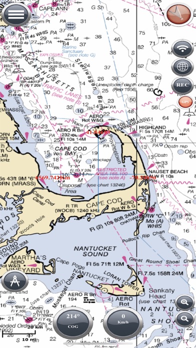
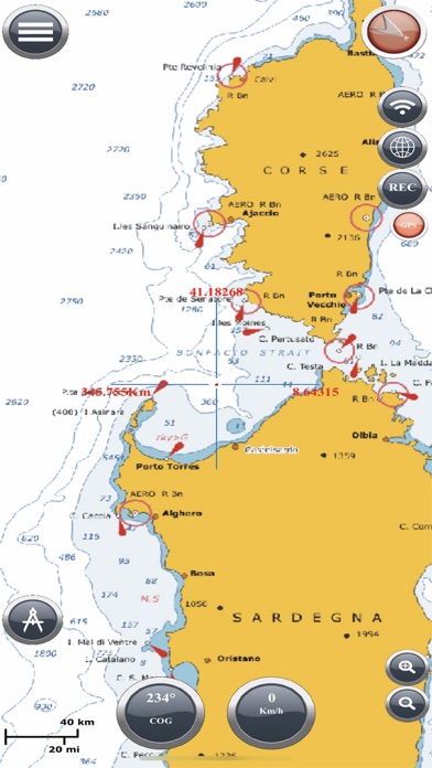
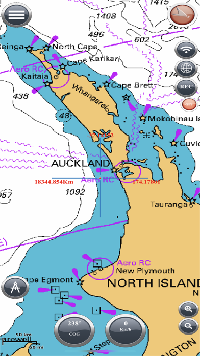
MAPS AND MARINE CHARTS
- NOAA Map
National Oceanic and Atmospheric Administration (NOAA), Marine Navigation use NOAA RNC raster United States waters marine charts
-LINZ NewZealand
NZMariner is the product name of New Zealand’s Official RNC (Raster Navigational Charts)
- Ocean Maps
Esri created and released a new, comprehensive map of the world’s oceans and coastal areas
- Topo Maps
This world topographic map (aka “the community basemap”) includes boundaries, cities, water features, physiographic features, parks, landmarks, transportation, and buildings.
- World Map
This map service presents satellite imagery for the world and high-resolution imagery for the United States and other areas around the world
- OpenSeaMap
Open Sea Map is a first opensource maps for the sea, with ports, sea light and more.
more information on : http://www.fishpoints.net/maps
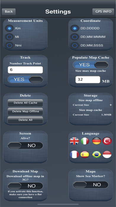
MAPS OFFLINE
You can download maps or marine chart, you need select area and application save tile in the disk. You can navigate on preloaded maps or chart without connection.
MAPS CACHE
Marine Navigation save for you maps and marine chart, when you see the tiles of maps the application creates an automated archive, when smartphone cannot connect you can navigate on maps preloaded.
FEATURES
- Navigator GPS
- OffLine Map
- Save on SD OfflineMaps
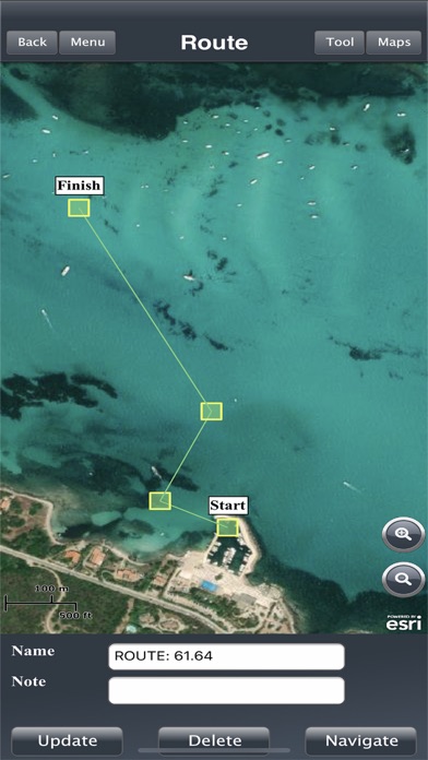
- Sync Route/Waypoints
- Interactive Map
- Deep Chart / Altitude Chart
- 4000 SeaPorts
- Active Pointer
- Create, Manage and Delete Route/WayPoints
- Way Tracking
- Share Image
- Anchor Alert
- Code Morse
- Moon Info
- Scale Interface
- Screen Alive
SOCIAL
Create your Yacht Club; share or import Points; Make the best marine navigation group.
-Login with Facebook Account
-Group (Public, Password, Invite)
-Create Your Group
-Archive Points
-Group Live Chat
-Group Share Image
-Admin Your Group
-Share WayPoints
-Import/Export Points
WHY USE MARINE NAVIGATION?
Because it is easy to use, you need only activate app, you don't waist time for install instruments on your boat. It is cheap, you don't need to pay a lot of money for sea navigation. You can get route information. Save your money and time, you think only about the marine destination.
HELP US
If you enjoy using Marine Navigation, would you mind taking a moment to rate it? It won't take more than a minute. Thanks for your support!
WARNING
Good seamanship requires the use of official charts. Marine Navigation is for use with other charts and cannot replace official charts. Use at your own risk.
VIDEO TUTORIAL
How create a new account - http://youtu.be/rUf4U4mQTwY
How Download offline map - http://youtu.be/MSTjDf-V9vI
User Manual - http://www.fishpoints.net/usermanual/
LANGUAGE
-British
-Italiano
-Français
-Espagnol
REQUIRED
-Active GPS
LEARN MORE ABOUT FISHPOINTS:
http://www.fishpoints.net and join us on Facebook, Twitter, Linkedin
Powered by Esri
Powered By NOAA
Reviews
A useless piece of crap! BEWARE!
cirinose
I hate getting ripped off and this is a total scam! Multiple emails with no response. Requested a refund twice with no response. Marco Palaferri is a con artist!
Don’t waste your $$$$
Ddo123sssant
Chart menu is almost impossible to search, charts won’t download so I ended up with a blank map.
Ripoff!!!
te brownell
They take your money and it doesn’t start up! Then it wants you to go through the whole thing again, taking mor money! This is a FRAUD!!! Rates -10!!!
No gps
Bvibob1
Could not connect to my iPhone gps. Unable to download charts, perhaps because of no gps?
Waste of money!!
stache85
This was a waste of money!! Does not work. I can’t download any maps. I ask for my location and it tells me I’m in Spain. Yes I have my Location on.
No results
Victory Now
I downloaded the app and am looking at a blank screen. Cannot figure out how to download charts; or 'maps' as they are called in the app
No longer works
Kent_H
Insists I enable GPS - which *is* enabled and rights granted to the app. Uninstalled.
Not worth it
DJ6220
How are you suppose to evaluate a program when the functions in the Lite version don't work? Given the track record of many apps I'm not spending any more money on promises if all features are activated say for trial period and I find it meets my expectations then I'll buy.
Need to log on via Facebook?
MicrophoneMixer
The app works as advertised but not having an alternate log in method means only 2 stars. I really don't want Facebook involved in navigating to my favorite destinations.
Useless
DBSteve
This app is useless. It is impossible to download any useful chart data. There is no logic to the way it selects the portion of the chart to download and you can't drag the boundaries of the selection to choose what you want to download. Then when you actually try to download a portion of a chart you get an error saying you can only select a 10 diagonal mile portion of a chart. As I said completely useless. It deserves 0 stars but you can't do that.