Marine Imray Charts
| Category | Price | Seller | Device |
|---|---|---|---|
| Navigation | Free | Imray, Laurie, Norie & Wilson LTD | iPhone, iPad, iPod |


Free technical support for this app is available for users of 2016 chart sets. If required, please email [email protected]
FEATURES
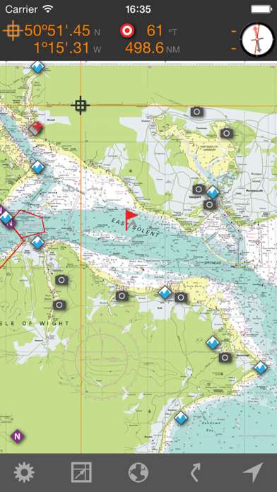
- Award winning raster charts from Imray
- Waypoints
- Routes: distances, targets, bearings
- Position and destination
- Course to steer, speed and bearing
- Magnetic compass
- Distances, bearings from any point to any point
- Electronic bearing line
- GPS and instruments
- Tides with full functionality from Tides Planner
- Aerial photographs (subject to coverage) and harbour plans
- Tracks that you can share with friends
Download charts from the Chart Store in the app.
Written by sailors for sailors.
Warning: Continued use of WiFi and of GPS running in the background can dramatically decrease battery life.
COVERAGE
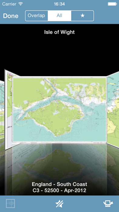
Imray Charts free app: English Channel passage charts, European and Caribbean index charts.
Imray ID10 North Sea: Belgium, Holland, East England and East/North Scotland.
Imray ID20 English Channel from the Isles of Scilly to the Dover Strait along the English coast and from Brest to Calais along the French coast.
Imray ID30 West coast of England, Wales, west coast of Scotland and Ireland. Land's End to Cape Wrath and the Orkneys.
Imray ID40 Atlantic France, Iberia and Atlantic Islands. Brest to the Strait of Gibraltar plus the Canary Islands, Azores, Madeira Group.
Imray ID50 Western Mediterranean. Gibraltar to Sicily.
Imray ID60 Central Mediterranean. Adriatic and Ionian Seas.
Imray ID70 Eastern Mediterranean and Aegean Seas.
Imray ID100 Eastern Caribbean. Virgin Islands to Grenada and Barbados with extended coverage to Puerto Rico, Bermuda and Trinidad.
Netherlands 1800 series: Zeebrugge and the Westerschelde to the Frisian Islands and the Waddenzee, including the river estuaries and IJsselmeer.
Germany BSH: North Sea from the River Ems to Lister Tief.
Germany BSH: Baltic Germany. Baltic coast between Denmark and Poland.
Denmark DGA: North Sea and Baltic (2014 data; to be updated for 2017)
Atlantic France and Iberia: from Brest to the Strait of Gibraltar.
Sweden SMA: Sweden East (2014 data; to be updated for 2017)
Sweden SMA: Sweden West (2014 data; to be updated for 2017)
France SHOM: Mediterranean France and Corsica
France SHOM: Biscay and Gascogne
Australia: north east, east and south coast (2013 data)
Tides - inherits permissions (beyond one day predictions) from the Tides Planner application if installed in the same device.
ABOUT US
Imray is the leading publisher of nautical charts, books and apps. Our charts, designed and published in England for nearly 200 years, feature popular, carefully edited and award-winning cartography.Ê
Look out for other applications in the Marine Navigation Series from Imray
Follow us on Twitter @imray_charts
Facebook @imraynautical
LANGUAGES
English, Dutch, French, German, Italian and Spanish
Reviews
Great, if you happen to be in the English Channel
rborroto
English Channel enthusiasts should love this dumb app since it's the only charts included, LOL!!
Coololishes
WOOSH WA WANG
I have always wanted to be a marine biologist and I think this app is kinda helpful
Good charts, limited software
Adelsam
Great chart images for the BVI. No mosaic/tiled feature to seamlessly transition between maps and zoom levels. Would be 100% with this feature!
Great coverage of the Caribbean
KY Solar Guy
The charts cover from Porto Rico to Trinidad & Tobago. Except for the detailed chart of the Spanish Virgin. We have it on both our iPhone and iPad. On the iPad it really works as a chart plotter. With the GPS it show quite precisely where you are, which can be very handy. It does lack a good manual, so the learning curve is a little long. So, four stars because of the lacking charts and lacking manual. Otherwise a very good product for the $49 or so price.