Map Plus
| Category | Price | Seller | Device |
|---|---|---|---|
| Navigation | Free | Miocool Inc. | iPhone, iPad, iPod |

● You can use Map Plus as a professional GIS tool for geographic data gathering, editing, measuring, cartography, surveying, planning, online/offline viewing and many other management.
● You can also use Map Plus to help your outdoor activities and global travels, for trip planning, offline map downloading, track/photo/video recording, or sharing memories with friends.
Besides common map features such as locating, searching, Map Plus has many more special:
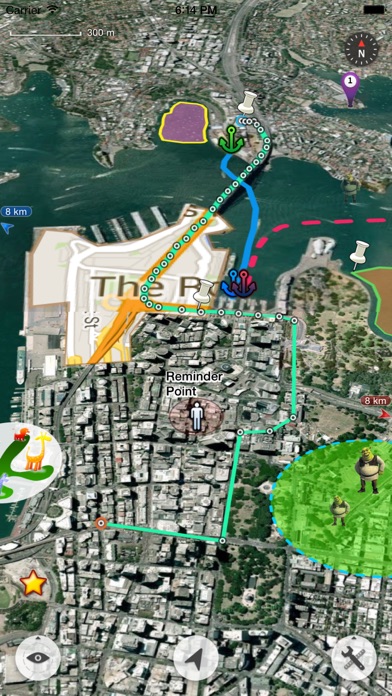
● Supports importing, viewing and downloading thousands of custom online maps, such as OSM, GoogleMap, BingMap, USGS, or any WMS/WMTS map services. Both XYZ pattern and Javascript could be used to define maps.
● Supports importing offline map files such as MBTiles.
● Supports both EPSG:4326 and Web Mercator (EPSG:3857) for raster maps; Supports offset maps using China GCJ-02 datum.
● Importing and exporting KML/KMZ files with full styles, extended data and "gx" extension support.
● Importing and exporting GIS vector files, such as SHP, TAB, GEOJSON, GML/GZ with all EPSG projections/CRS. (using GDAL)
● Importing/Exporting AutoCAD DXF files with blocks, mtext, xdata and affine transformation support for coordinates mapping.
● Importing files of CSV, GDB, MPS, WPT, EVT, PLT, PNT, RTE, etc.
● On-map Editing with Drag-Drop and Magnetic Snap support for all places, tracks, lines, polygons, circles, rectangles, text overlays, etc.
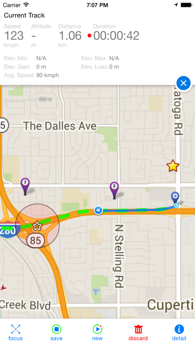
● GPS Track Recording with auto-recovery, custom time zone and background mode support.
● Path Following with voice guidance for own lines/tracks or searched out direction routes.
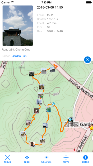
● Displaying photos and videos on the map based on locations.
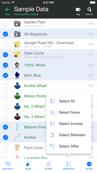
● Managing mass data with multi-level folders, layers, bulk operations, shortcuts, tags and fuzzy searches. Advanced Search supports expressions and property conditions.
● Using Feature Class for bulk editing and managing on similar (same kind) features and layers all together. Supports bulk Attributes Merge and Link Relationship Building between features of different classes.
● Conditional Style, Script Property and Expression provide dynamic content of rendering, attributes and text labels.
● Customizable pop-up panel for selecting items on the map with HTML, JS and CSS support to make your own forms, layout and rich-formatted content.
● Displaying coordinates in MGRS or UTM.
● Photo Markup enables you to add arrows, texts, shapes, icons and free-hand draws to a photo.
● Browser Access enables you to upload and view data from a web browser on PC/Mac within a Wi-Fi network, or play slideshow on your TV for travel photos.
● Sharing or transferring data via Wi-Fi, Bluetooth, iCloud, SMS, Email, QR codes, Open-In, AirDrop or many other ways.
● Backup & Restore function helps you backup/restore data to/from files or iCloud easily.
● Many more fantastic and free functions could not be fully listed here, such as Guide Mark, Arrival Notification, Photo Mode, Map Level Adjust, Custom Icons, Photo/Video Attachments, Image Overlay, Text Overlay, Fast Editing, Distance/Perimeter/Area Measuring, Custom Time Zone, etc.
User Manual:
http://duweis.com/en/mapplus_guide.html
User Forum:
http://duweis.com/forums/viewforum.php?f=13
Contact Us:
[email protected]
Reviews
used the free for 3 years
Ncpage2007
Great app! used the free for 3 years before buying 2 of the enhancements. thank you
Great tool for navigation and mapping
baidarkabob
This is the best gis capable mapping app for at least a couple years running
Awesome for GIS
Ian.Moone
all of the apps that are out there are too hard to operate and cost a lot. this app is simple and very straight forward.
Great app for creating .kml files
Hunt123hunt
I use this app a lot to create .kml overlays for another app called ForeFlight. It work very well and is easy to use.
Great app
dandy bucks
Love this app. I use it for hunting and scouting. My only issue is I can not get the satellite map overlay to work. It would be huge if that feature worked properly. It pops on then goes back to a blank background. Any help would be appreciated. Other than that I'd give it 5 stars.
Great!
a-man84
I'm a rural postal carrier. Use this app to record new routes I learn so it's easier for me to do them on my own. Some are over 100 miles weaving around gravel country roads and this app works great!
Like it a lot so far
Aaaaaa5
Good app so far. Interface takes a little bit getting used to. Does everything I need it to do.
Map Updates
Dj728372
It would be nice if the map would be updated soon. Maybe if you could take each years satellite image and allow you to look at what ever years aerial view that you would want. I know the map I look at is at least 9 or 10 yrs old. It would be useful in my line of to be able to look at multiple different years of satellite images.Just a suggestion. Love the App though