LeadNav GPS
| Category | Price | Seller | Device |
|---|---|---|---|
| Navigation | $19.99 | LeadNav Systems LLC | iPhone, iPad, iPod |
Built by operators for operators, with decades of experience leading technology innovation in the field.
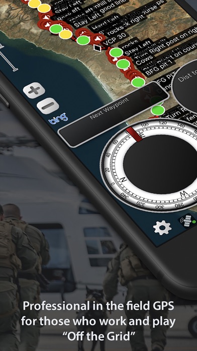
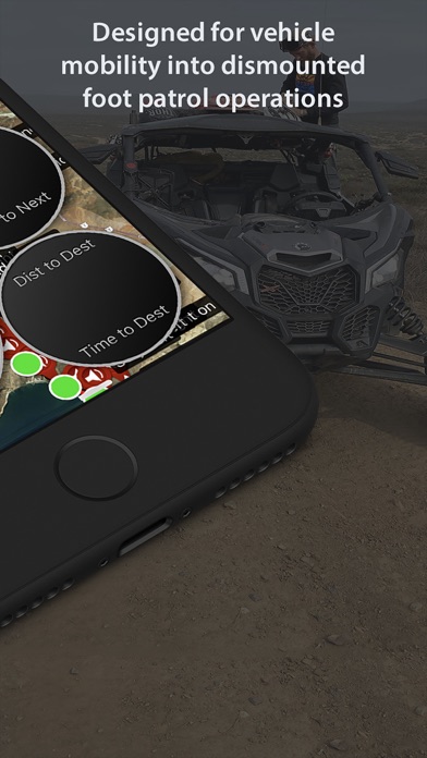
Focused on mobility into dismounted foot patrol operations, LEADNAV currently provides full mission packages in the form of Software, Hardware, Training and Consulting for those operating in some of the harshest conditions and environments imaginable.
Used by many, to include off-roaders, security and response teams and other Professional Organizations World Wide!
More Powerful than any other GPS on the Market!
Features:
• Plan, Organize, Coordinate and Execute Trips, Events and other Professional Operations.
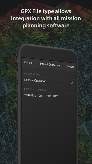
• Create or Import Collections of Routes, Tracks, and Markers for different events. (Baja 1000 2019, Mining Expedition 2020)
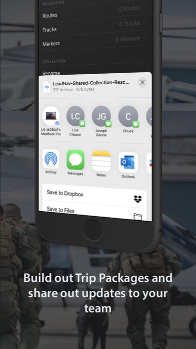
• Share individual Routes, Tracks, and Markers amongst your Team or Group.
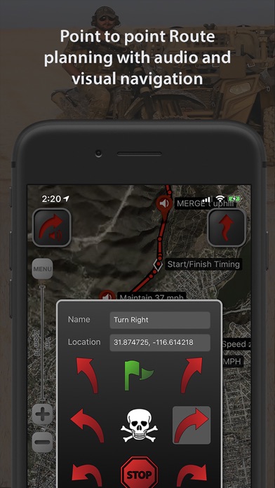
• Easy to use point to point Route Planning Interface. Plan your route and go!
• Drop audible warnings and non-audible Serpentine points to keep you on track.
• Record tracks to display where you have been. So you can hit the trail again or find your way back. You can also convert your tracks to routes. Track Stats for each trip.
• Highly advanced Team Location Tracking through our cellular/wifi, preprogrammed Iridium GO! units (Satellite device and our service plans) and other specialized equipment under contract.
• Reverse your routes. Hike to the top and then reverse the route to hike back down!
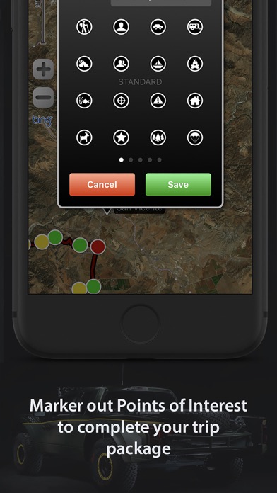
• Drop Markers to identify places of interest or to document the experience as you go. Vehicle, rally point, boat dock, deer, or anything else you want to find again.
• System functions on the GPX file standard
• Free online Map Sources include Bing, OpenStreetMap, USGS Satellite and USGS Topo
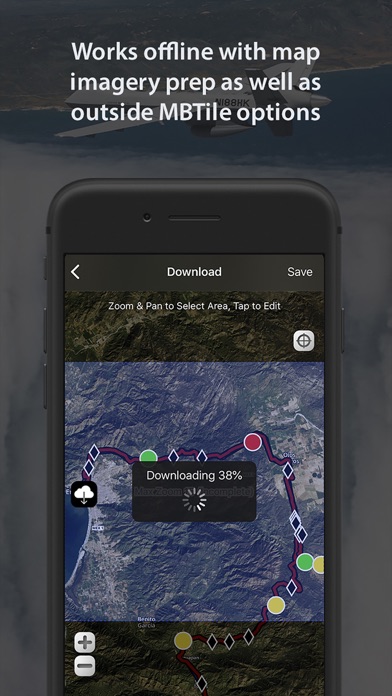
• Support of offline mapping options like MBTiles and overlays with our Pro Pack subscription and contracted services.
• Subscriptions allow access to additional features and maps (Mapbox Satellite, Mapbox Terrain, Mapbox Streets), and access to your own URL entry (Part of the Pro Subscription). Create, cache, and delete maps with your custom URLs. *Maps subject to change by the providers
• Offline Mapping for areas with no cellular coverage. (yearly subscriptions) Select and store desired areas of the map for offline use. Download those maps before you go in the field!
• Compatible with Bluetooth headsets and speakers for eyes free navigation. Throw your device in your pack and GO!
• Voice Prompts automatically adjust for the current speed. Siri now reads the waypoint label names as you navigate. “Big freaking rock on the left!” Get creative with the names to make the most out of your experience.
• Automatically adjusts your audible (Red) Turn Warning and (Blue) Waypoint Proximity rings based off of your current speed. Giving you the information you need when you need it.
Audio Guidance Examples:
“Slight Left in 450 meters” ...... “Slight Left”
“Danger in 500 meters” ....... "Danger"
—————————————————
Additional In-App Purchases: (See website for all subscription details)
- Advanced Pack Subscription (recommended for those on foot covering smaller areas)
- Pro Pack Subscription (recommended for those in vehicles covering larger areas or needing our more pro level features listed on our website)
- Recon Markers
- Hunting Markers
- Aviation Markers
Note:
• This is a high powered GPS device and requires power connectivity for prolonged use in the field.
• Mobile devices that are WiFi only do not come with an internal GPS. An external GPS will need to be used along with the application.
• The capability to save satellite maps/imagery to your device for "off the grid" use is an outside service and requires a yearly Subscription
Battery Life Disclaimer: Continued use of GPS running in the background can dramatically decrease battery life.
Reviews
Great app, slightly outdated UI
Jonathan_the_Engineer
This app is well made. Easy to use and good for offline navigating. I use it when going off roaring or traveling outside the US. I find the buttons on screen to be somewhat clunky and instructive. It would be great if you could tap on the map and hide unnecessary things. A minor inconvenience.
Good Concept, Poor Implementation
rmay18591
Map box maps are not very good in this app. Needs contours draped over aerial imagery. Buttons for editing need to be on map screen. Needs desktop editing capabilities. Better tutorials, documentation. The voice routing waypoints is very nice. It is a pain for the remainder of UI
BEST $20 You'll EVER spend....!
OHPRG Program Director
LeadNav killed it once again at the SEED 9 Rally this year....! Easiest GPS to use, big clear screen to view, maps downloaded for "off grid" use....would have been lost in the dark of a night-rally without it....
The BEST gps app I have used.
Adammm68
Buy it. Pay for the map subscription. Download maps for use offline/no cell service. Know where you are. Build courses. Record tracks. Share via airdrop or email etc. I haven't been happier with an app purchase. Very solid app, with excellent customer service and support. I use this app at least once a month, and recommend it to anyone that is ever off the grid. Such a valuable tool at one tenth the price of a comparable independent handheld GPS unit. I use it both on my iPhone 6+ and iPad Pro. Everyone that starts playing with it on my devices, immediately searches for and purchases it. 5/5 stars. And it will only get better - because the support team actually cares about their user base.
Best off road gps app out there
John Ferrari II
Just buy it. Get the map subscription ($20/year). Works perfectly. Developer is very, very active in the development and support of the app!
Awesome app
Harshman98
This app is amazing. Would definitely recommend buying it! Worth every penny and then some
Misleading
Thedodd87
I don't doubt this app could be great if your willing to pay the additional $149 subscription fee and or other additional fees. It's basically Google earth all the tools and features they show are unavailable unless you pay additional fees. The add is misleading. The app is useless without the subscription. I want a refund ?
Best navigation app!
JerryZhb
We have been using different navigation apps. Leadnav by far is the best. Having the imagery offline makes this app perfect for trips down in Baja and in remote areas.
Great app
Zoeys
Great app used it for pre running in Baja. This app is well needed I put my old fish finder back in my boat.