
Korea Rail Map - Seoul, Busan & All South Korea
| Category | Price | Seller | Device |
|---|---|---|---|
| Travel | Free | TOKYO STUDIO INC. | iPhone, iPad, iPod |
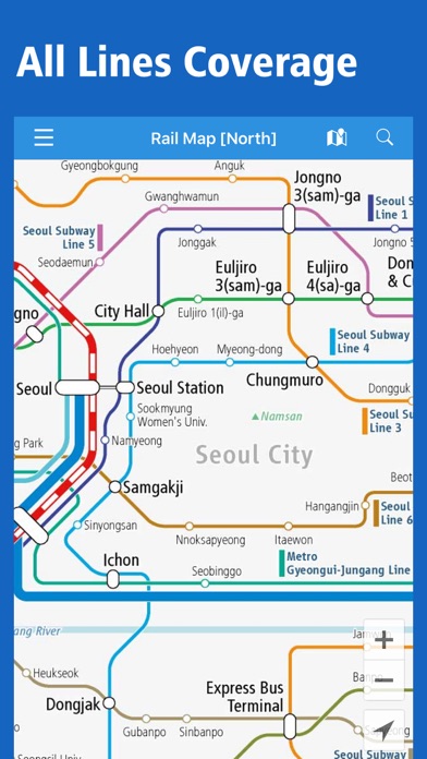


- Seoul Subway & Incheon Airport Railroad
- KTX & KORAIL
This application offers the railway maps covering all over South Korea.
We hope this app will be of help to your smooth transit and good travel!
[Main Features of the latest version]
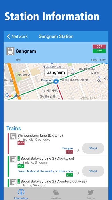
- Searching by the station name
- Jumping to your present location
- Train information from every station
- Stops & transfer information of all lines
- Check tweets around the station by connecting with Twitter
- Free automatically updates to the latest versions of maps
- Flexible zoom up and scrolling
- Switch to Street Map View at every stations
- Weather information around the station
- Offline browsing is available (If you downloaded maps in advance)
- Multiple languages
[Area Coverage] *All Lines, All Station in South Korea*
- KTX (High Speed Railway)
- KORAIL: Gyeongbu Line, Honam Line, Jungang Line, Jeolla Line, Gyeongjeon Line etc.
- Incheon International Airport Railroad (A'REX)
- Subway & Metro: Seoul, Incheon, Daejeon, Gwangju, Daegu & Busan
- Airports: Gimpo, Incheon, Gimhae, Jeju, Cheongju, Muan, Yeosu, Daegu, Ulsan, Sacheon etc.
Reviews
bigmama
Ged45678
worked very well for us during our visit; a fifth star would be given if it provided routes closest to destination
Needs help
This app doesn't help
Not beneficial to tourists or people who don't know the area. Can't search city names to find the closes train station. Please do in house reviews with actual tourists testing because it's not useful with out knowing the area first
Can’t see the whole map!!
Wes Groleau
How can I decide where to go or plan a route with an app that pretends the country is two disconnected pieces? Let me zoom out to the WHOLE country, not just half of it!! (and I am not talking about the nutcase to the north. I’m talking about Busan and Seoul being on different maps and you’re not allowed to have both on screen at once. Silly)