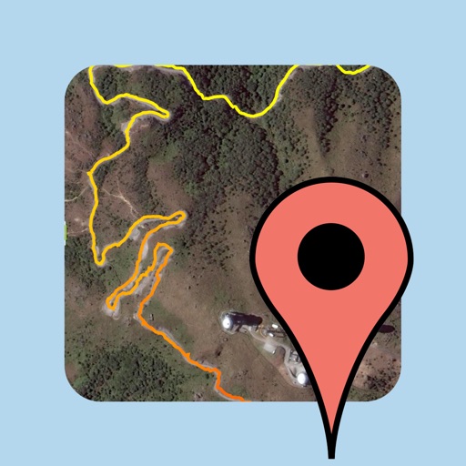
JAS Location Tracker
| Category | Price | Seller | Device |
|---|---|---|---|
| Navigation | Free | JAS Solutions Limited | iPhone, iPad, iPod |


The journeys can be exported into the standard KML/GPX formats, which can be viewed, edited, and stored by many popular software products such as Google Maps, Google Earth, Bing Maps, and more.
All functionalities are available for FREE! There are no limits as to the number of journeys, tracks, points, placemarks, or anything.
This app is supported by ads, which you can remove through an in-app purchase.
-------------------------------------------------------------
Major features:
▶ Background updates
Record your location while in the background. You can lock your device, switch to another app, or listen to music, and new location data can still be recorded.
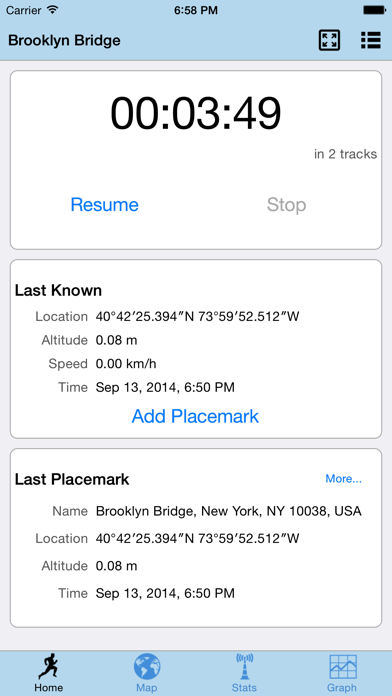
▶ Resume journey
Resume your journey even if you have stopped it by mistake.
▶ High accuracy
Intelligently skip inaccurate location data caused by occasional bad reception.
▶ Placemarks
Add and name placemarks at the current location.
▶ Google Maps
The journey is presented on Google Maps, supporting such map types as Normal, Satellite, Terrain, Hybrid, and Traffic.
▶ Graphs
Visualize the journey in graphs, which you can enjoy studying and analyzing.
▶ Statistics
Detailed statistics are available, including speed, altitude, distance, time, and more.
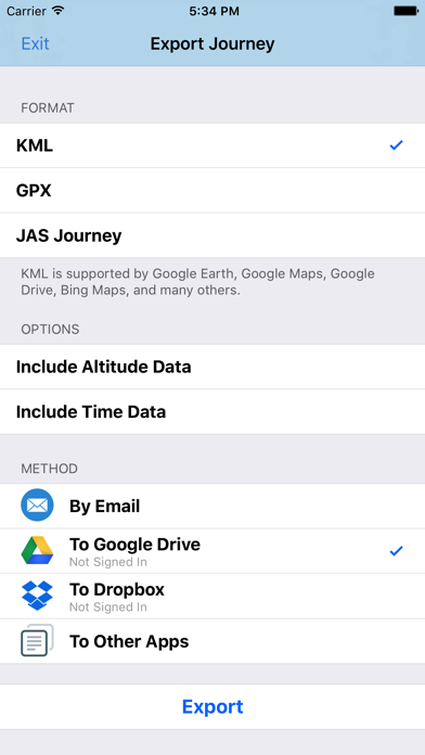
▶ Export formats
Export a journey as a KML or GPX file, which are common, standard geographical file formats supported by many popular mapping and geographical information applications and services, including Google Maps, Google Earth, and Bing Maps. Or, export it as a JAS Journey file so that it can be imported back later.
▶ Export methods
Send an exported journey as an email attachment, upload it directly to Google Drive (formerly Google Docs) and Dropbox, or pass it to other apps such as Google Earth and Evernote.
▶ Share screenshots
Share a screenshot of the current map or graph onto Facebook or Twitter, email it to your friends, save it to the camera roll, or share it to other apps like WhatsApp, Line, Google Drive, Dropbox, and Evernote.
▶ Multiple journeys
View a journey while the app is recording your location into another one at the same time.
▶ Journey management
Manage all your journeys - create, delete, rename, duplicate, and so on.
▶ Low battery reminders
Alert you with notifications when the battery level is low.
▶ Screen orientations
Fully support portrait and landscape orientations. Rotate any time to suit your needs.
▶ Fullscreen mode
Switch to fullscreen mode at any time for a larger view.
▶ Rich configurations
Lots of configurable options are available, such as location accuracy, units of measurement (e.g. km vs mile), and many more.
▶ iOS support
From iOS 9, to the latest iOS 10; from the smallest 3.5-inch iPhone 4S, to the biggest 5.5-inch iPhone 7 Plus.
▶ Apple Watch
Start or pause your journey right from your wrist.
▶ Low battery usage
The usage on battery is minimal. On a fully charged iPhone 5 running on iOS 7, it can keep on recording your location with the highest accuracy for over 9 hours¹.
▶ Low resource usage
The usage on CPU and memory is minimal. We work very hard to reduce the usage on these precious resources on your mobile device.
▶ No network required
No internet connection is required to record your location. However, some functionalities wouldn't quite work without the internet, such as the Google Maps, or the ability to upload your exported journey to Google Drive.
¹ With "Deferred Delivery of Location Updates" turned on. Actual battery usage depends on many factors. Your mileage may vary.
-------------------------------------------------------------
IMPORTANT NOTES:
- Continued use of GPS running in the background can dramatically decrease battery life.
- Stay alert, be safe. Always keep your eyes on the traffic while on the move.
Reviews
ATV
Tank trucker
Used on a off road in the woods ATV trail ride today. 61 miles. It worked great. We wanted it for a crumb trail. It was a great app. Would highly recommend! Thanks!
Very decent and battery conserving
Mike11939
I was looking for a free GPS app that I could use when I check out hikes for a dog group I'm in. There are many apps that can do this, of course. However, when I actually tested them, I discovered that most would eat up your battery in short order. Some would not work unless the app were on and in the foreground all of the time. Also, some would not let you export the track you created. Some would not let you use the app unless you signed up using Facebook or an email. JAS tracker has none of these negatives. It's fairly easy to use as well. (Unlike Viewranger...which is great but way too complicated.) You can export right to Google Earth or as a GPX file. I hiked for an hour and a half and it only used 8% of my IPhone 5s battery. It's got nice free maps with it that I believe you can use offline as well. I don't know why this app isn't more popular.
iPod touch is sketchy
Moo1000
Interesting user interface. App uses some combination of cell towers and gps for location. An iPod has no mobile radio. GPS only tracks are very erratic.
Simple & "light weight"
DHC-avid-reader
Just what I was looking for to track my travels all day on one charge!
Amazing!
jetsurly
I've been looking for an app to track my driving routes and I must say, this is by far the most amazing app ever. After another app that clears "fog" away from a map stopped developing and responding to customers, I found JAS and could not be happier. This team is genius! Such a great app for tracking routes and getting all the fun info you never expected. This is definitely one of my most used apps
Does not work on an iPod G5
Clustered
No track made when left running on an iPod touch. It appears to require a phone with internet connectivity to do anything.
Great App
OverTheTop75
Perfect match for the Apple Watch and iPhone. Start stop and active track log on map on the watch. Works great
Worked Great! In China too.
The Grand Poohbah
We tested the JAS Location Tracker last weekend at the Maker Faire in San Mateo. It performed beautifully. I was using a Sony Alpha 6000 which does not have a GPS. I used Graphic Converter to add the JAS Location data to the photos taken on the Sony Alpha 6000. Every photo got location information. Excellent. In addition to the location data, we got the total miles walked and a great map that showed everywhere we went. I especially liked the Apple Watch connection. This is an outstanding app for the price. I also used the JAS Location Tracker every day for the three weeks we were in China. Got track maps for Hong Kong, Guangzhou, and Yunnan. Used the track data to add locations to my photos. Worked flawlessly.
Just right!
mike78708
Love the app. It was exactly what I was looking for. Does everthing that I need without all the extras that I don't need!