
EasyTrails GPS
| Category | Price | Seller | Device |
|---|---|---|---|
| Sports | $3.99 | Zirak Srl | iPhone, iPad, iPod |
The perfect application for those who are passionate about OUTDOOR ACTIVITIES and TRAVELING, everybody who likes outdoor sports, and not only.
- Featured by Apple in November 2014
- BEST OUTDOOR APP 2009 by 148apps.com
- BEST Italian APP 2011, 2013 Sport by macitynet.it
- More than 100 weeks at top 10 Sport IT
- More than 14 weeks at overall top 10 IT
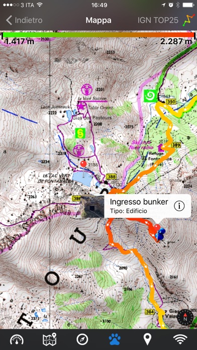
Are you going for a bike or motorcycle ride? Well, EasyTrails GPS will tell you how many miles you traveled, how much time you spent, how high you climbed and many other details. In real-time it will show you the course on a map, comparing it with downloaded tracks and points of interest.
You can import or share all tracks and waypoints, photos and ideas for new journeys with your friends.
Share where you are on Facebook and Twitter through your GPS position, and export your tracks in standard formats, so you can review them on Google Earth, SportTracks and TrailsRunner. Or simply upload them to online services like Garmin Connect, or many others.
It's possible to import tracks by e-mail or Safari (EasyTrails can handle GPX, KML/KMZ and ZIP file formats), or by wi-fi networks, using an improved and easy to use web-based sharing feature.
Calculate routes and let EasyTrails guide you using the new navigation capabilities. You can also let it guide you through previously recorded tracks.
Additionally, EasyTrails GPS can communicate with navigators like Maps, Google Maps, TomTom or Waze (if installed) for more advanced guidance needs.
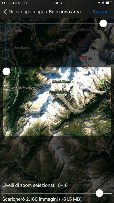
Load custom cartography, EasyTrails supports KMZ and MBTILES formats.
EasyTrails GPS is easy to use and extremaly accurate. It ensures the maximum duration of battery thanks to the possibility of recording in "StandBy" mode. However, be aware that use of GPS, even in background, will have a significant impact on battery duration.
► For more info, visit our website: www.easytrails.com
NEW FEATURES:
► Heart rate monitoring (paid)
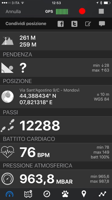
We added the ability to connect to compatible Bluetooth heart rate monitors (such as Polar H6 and H7 devices). Heart rate can be seen in real time from the dashboard.
With the 'Heart rate monitoring' in-app purchase:
- heart rate data will be associated to GPS tracks
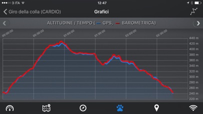
- saved tracks will have an extra heart rate chart
- heart rate data will be saved to HealthKit
Additionally, with the 'Colored tracks' in-app purchase, it will be possible to highlight heart rate data directly on the map screen of a recorded track.
OTHER FEATURES:
- Support for many different map types
- Support for different coordinate systems
- Support for user-loaded offline cartography (KMZ and MBTILES)
- Export tracks (single or multiple) in standard formats (GPX, KML/KMZ and CSV), with their associated waypoints and pictures
- Import tracks (GPX and KML/KMZ)
- Import waypoints (GPX and KML/KMZ)
- Resume recording of tracks
- Save waypoints with photos and descriptions
- Navigate to a point of interest
- Sharing via Facebook and Twitter
- Follow a path/track
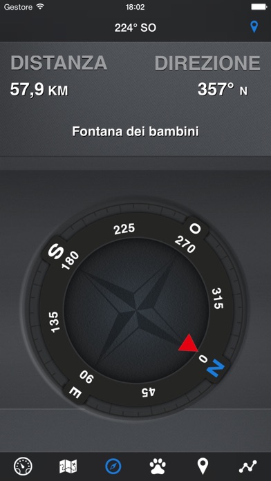
- Navigate (distance / direction) towards any waypoint
- Navigate (distance / direction) towards any track marker (start / pause / resume / end points)
- Advanced Navigation to a waypoint using any navigation app you may have installed
- Upload tracks to GPSies (http://www.gpsies.com)
- Upload tracks to SportTracks (http://sporttracks.mobi)
- Upload tracks to OpenTrail (http://www.opentrail.us)
- Upload tracks to OkMap (http://www.okmap.org)
- Real-time visualization of distance, speed, altitude bearing and other data
- Map Visualization in different modes: street map, satellite, hybrid, terrain
- Charts (elevation profiles, ...)
- Digital Compass
- Heart rate monitoring
- Turn by turn directions
- High battery duration (record in standby)
- Select between metric, imperial and nautical measuring systems
- Intuitive and User Friendly interface
- Lightweight, reliable and accurate
- Doesn't require internet connection
Reviews
Very good GPS logging app
awesomejt
This is a strong consideration for anyone looking for a geo-logging app. The app shines with the constant logging feature of the app. This app actually works with the phone's sleep mode -- not some "fake sleep" dim screen mode that other apps use. That works great for me, I'm so used to pushing the phone's sleep button that disables other apps. The other killer feature is the signal strength indicator -- let's you know the quality of the gps fix on the phone -- which is awesome. I've tested many apps that log gps data, but without knowing the quality of the signal, you may end up with invalid data or even no data. Although there is a speed and altitude indicator -- neither one are very accurate. I can be standing still at the beach but it reports I'm moving at 10 mph and at 95 ft above see level. It is more or less dependable based on the quality of the gps lock, but even with the best signal strength -- these values are way off. In addition, I wish the waypoint/manual point entry was easier or more streamlined -- and could be done without interrupting the existing recording. For constant logging mode, it would be great if you could control the frequency of the data points recorded -- that might save on battery life. I think it should be an option at least. The help or documentation (online or on phone) is much better than most other apps, but still very lacking. Most apps have no documentation at all -- some documentation is better than average. I'm using this app for geo tagging my photos. It allows access to GPX (and other) files via an internal web server -- which is great. As long as the date/time on my camera is in sync with the phone -- my photos get geo tagged very well with GeoSetter (free). This app is better than most photography centric gps logging apps -- not many photographers know about this app because it is listed under Sports section instead of Photography. For my purposes, it is currently my favoriate app for geo-tagging, but still has plenty of room for improvement. I look forward to future releases.
Excellent for Trail Map Creation
MN Trails
Wonderful app for creating trail maps with points of interest along the trail. You can use the IPhone camera to capture the POI. Very easy to use -- Just start EasyTrails and push the record button. It automatically collects the GPS points and displays the trail as you walk. It works great with the IPAD and the IPhone. In my experience,the GPS sensitivity on the IPAD is much better than my Garmin Etrex that I have used to document trails. I found that you can start EasyTrails recording your trail on the IPAD and then put it in your backpack. It recorded a new 5 mile trail perfectly. It doesn't get any easier! I found the altitude and distance seemed to work fine! You can export the trail via email and share with friends. It also creates a GPX file that can be used with other programs and Google Earth!
Does not work!
Np3ba
I just installed IOS 4 and guess what Easy Trails does not record while on stand by anymore. I use this app for Mountain Biking but now I have to wait for and upgrade or for them to fix this bug. Dont buy this app if you have an Iphone 3G! Tried contacting custumer service but never recieve an answer. Upgraded to version 4.1 still does not work!!
Hard to find maps
Misterpeet
If you're hoping to download maps or trails that others have already posted, you're better off with Everytrail. Easytrail does not have it's own collection and finding gpx maps on the web isn't as easy as you would think. Even if you find a map of a trail you want to explore, it won't load if there are too many waypoints.
Great, Fun and Easy!
Buildrite
Just downloaded this on a whim.... My Garmin bike computer needs a new battery to the tune of $50+ for the service, so thought I'd give this a go. Went on a 22 mile mountain bike ride, and had easy tracker track our ride. It worked great, the only thing I noticed amiss was the assent and decent numbers didn't match, which if you start and end in the same place, of course should match. But overall, the 3 types of maps are quite cool, and shows the locations that we stopped with yellow push pins the overall time as well as the actual time we were moving. The ride was easily exported to email and mailed to a friend....Just not sure how to open a GPX file.....Guess I'll have to figure that out, maybe the developer has some info on that.....HIghly recommend.
Battery eater
Andy503
Don't know how they say it does not kill the battery, b/c it does. Severely. Otherwise good.
A great app that I've used for a year.
Buffalo guy Idaho
I've used this app for a year now and it has been very useful. I have come across a few puzzling glitches though. One, when I use it alongside other apps that use gps, the app occasionally stops recording the track and the whole gps system freezes. It has only happened on a couple of occasions and may by the fault of the other programs but it was inconvenient nonetheless. Two, for some reason I can no longer export my tracks using the web browser, instead I have to email them to myself. The tracks are very accurate when I have it out in the open and visible to the satellites and I think the interface is pretty self explanatory. Those who complain about the accuracy either are using it without letting it get a good signal or are using it for things beyond the capability of the iPhone. Sometimes you just have to be patient and wait for a good signal. If the good signal doesn't come then I have turned the airplane mode in and off or turned the app on and off which solves the problem pretty quickly. One thing that would be nice is a feature which would allow me to upload kml/kmz files of polygons or other information so that I don't have to switch to google earth to monitor where I am in relation to polygons I can only view there. It would also be nice to be able to cache more maps so that when I'm out in the sticks I don't have to stare at a blank screen. Idaho and Nevada don't have the best cell coverage.
Great app!
SCROTUM50
Excellent app. Very accurate tracking. Easy to use. Please join me in spreading the word about the biggest cheating app in the app store. A pool game called Micropool by Botond. Horrible game. Please read the reviews if you don't believe me. Please help by telling everyone you know about this atrocity. Thank you.