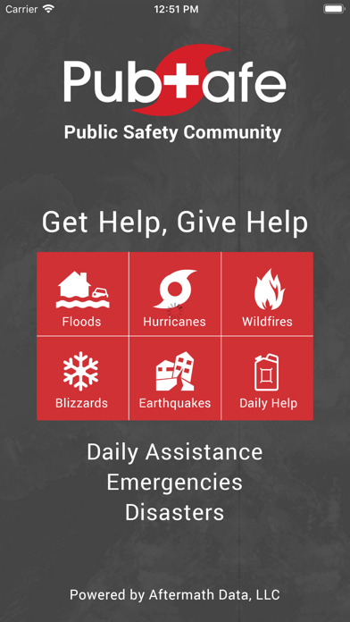
Citizen Network
| Category | Price | Seller | Device |
|---|---|---|---|
| Social Networking | Free | Aftermath Data llc | iPhone, iPad, iPod |


Features
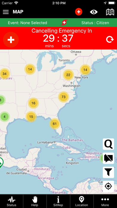
• My Status – share your status with other app users, family and friends in case of an emergency or to
coordinate search and rescue efforts. Sharing your exact location on the map in an emergency can
significantly improve the rescue response time.
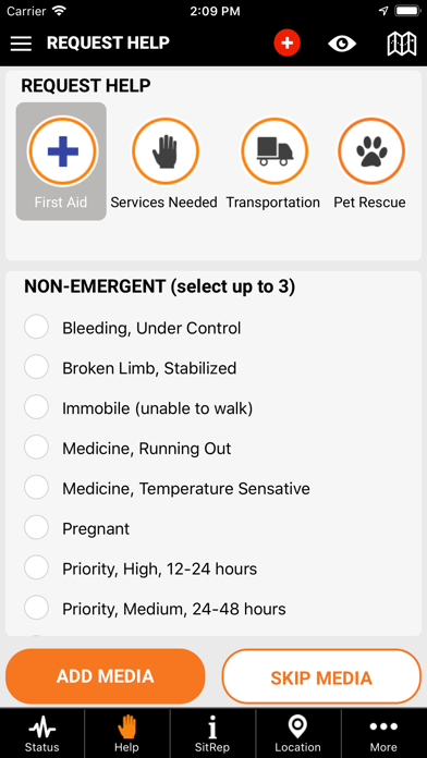
• Help – Request help for daily, non-emergent, issues such as running out of gas or needing hay to
feed cattle during a disaster.
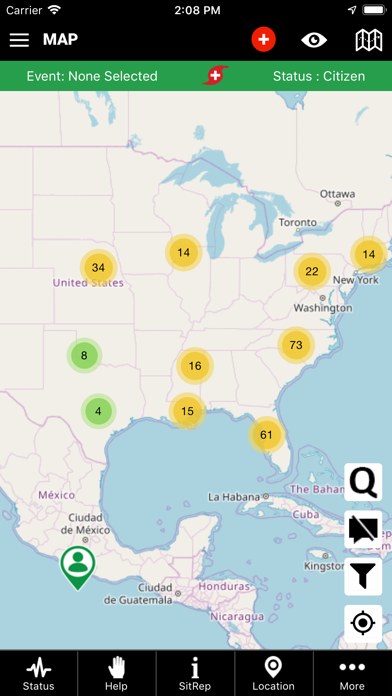
• SitReps (Situation Reports) – Status reports of what is happening in your area at a moment in time so
all users and emergency responders remain situationally aware.
• Locations – Identify the location and status of relief depots, rally points or an incident command
post to avoid situations like the Super Dome in New Orleans.
• Emergency – Life and death issues are share in hopes a user in the area can render aid before or in
support of a government response effort. In a disaster 911 or emergency personnel can be
overwhelmed. Another app user may provide faster response.
• Invisible – Hide your user location on the map for safety and security.
Applications
• Animal & people rescues
• Coordinate search and rescue efforts
• Boating ¬– tow, fuel, search, location sharing
• Large scale disasters – see where and what help is needed
• Hiking – quickly find others or facilitate rescue
• Travel – USA and Internationally
• Camping – find others to facilitate rescue
• Hunting – find others to facilitate rescue
• Lend a helping hand
• Provide or request clothing
• Provide or request animal food or shelter
Mapping the collected data is essential to for response efficiency. Data shared by users is displayed on the map which allows others in the area to be alerted and notified of what and where is needed. Although 911 or emergency centers are not connected to the app, they are encouraged to take advantage of the resources to monitor help requests and emergencies in their area of operation. The base platform and information is free for government to use to improve emergency and disaster response efforts. Often, the closest and fastest help may be another user. First request should always be 911 or emergency services. first and Then post to PubSafe.
Behind the scenes, anonymized data is be available to local, state, and federal governments. Data is not sold or shared for marketing purposes. Data is used to study the location of help requests, movement of people before, during and after a disaster. And to aid in keeping people informed of issues in their immediate area as they travel the United States and eventually globally.
Visit www.aftermathdata.com for more information.
Reviews
Great idea. App is coming along
AAIler
America needs a service like this. Join and tell your friends and family.
People helping people
bigt1111222334
Great way for communities to help each other. Bridges the gap that require multiple apps and tools today. With all of the civilian organizations out there today this app helps coordinate effectively and efficient across multiple organizations. Weather you are SAR or just want to help and be helped download this today.
Amazing tool for managing crowd sourced assistance and rescues
Flaperson
App provides a way to organize and manage crowd sourced rescue efforts after natural disasters. It can also be used for routine help such as road assistance. Many, many options available for organizing and managing crowd sourced assistance. Mapping options make it easy to identify the location of citizen responders as well as those that are requesting assistance. Great tool for those that want to provide assistance but do not know how or where to go to be of assistance
Seemed ok, but then. . .
Flyer213
Had this app for a month or so. Until last night, the weather notification piece worked well, giving timely local updates. Last night, at 2:14 am, I got some 20 notifications about severe thunderstorms in Oklahoma. Problem is, I’m in Florida. Since I can’t trust the app, I deleted the app.
The perfect app for anyone who wants to be prepared in the event of a disaster.
austinaustinaustinaustin
I downloaded the PubSafe app in case of a natural disaster. Communication is the greatest tool for survival in the event of the worst. PubSafe seems to be well designed and I would trust it in the event that I need to use it.
POC- Stateside and International- HARP
Twin Creek Kristin
This application has the potential to be a game changer in the sense that we now have a way to connect the government, local Emergency Management, NGOs, SAR, Relief Aid, and citizens in the path of disasters. Once the application use hits critical mass this tool will be invaluable to everyone connected in the Humanitarian sector. It’s been a long time coming and I’m so grateful someone with the skillset finally launched it.
Innovative Search & Rescue Tool
emil813
A functional tool that is quick and easy for anyone to use - any age, any tech skill level - to both request and lend services in times of need. Quick and simple to drop your location and a request for help. A great variety of situations in which this app can be used. Spreading the word and getting more on board with the app will only make it that much more effective - and will get you and your family/friends the help they might need.
Being from The Caribbean and living in FL...
islandgyal152
This app is an amazing resource for crowd communication during disasters and tools to find assistance in troubling times. Safety is the key!
Design is great. Valuable App.
Lilballer0924
This app looks great. Living the the Sunshine state this should be mandatory for all residents. Thank you to the developers of this app.
Interesting Concept
HeavenHillHammock
Interesting concept with a super sketchy privacy policy. This is one that you don't want to skim past. It was enough for me to cancel signup.